Springfield, Kentucky
| Springfield, Kentucky | |
|---|---|
| City | |
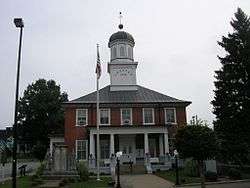 Washington County courthouse in Springfield | |
| Motto(s): "Where the Lincoln Legacy began" “Hollywood South” | |
 Location of Springfield in Washington County, Kentucky. | |
| Coordinates: 37°41′11″N 85°13′19″W / 37.68639°N 85.22194°WCoordinates: 37°41′11″N 85°13′19″W / 37.68639°N 85.22194°W | |
| Country | United States |
| State | Kentucky |
| County | Washington |
| Government | |
| • Mayor | Debbie Wakefield |
| Area | |
| • Total | 2.5 sq mi (4.1 km2) |
| • Land | 2.5 sq mi (4.1 km2) |
| • Water | 0.0 sq mi (0.0 km2) |
| Elevation | 768 ft (234 m) |
| Population (2010) | |
| • Total | 2,519 |
| • Estimate (2016)[1] | 3,123 |
| • Density | 1,007.6/sq mi (614.4/km2) |
| Time zone | UTC-5 (Eastern (EST)) |
| • Summer (DST) | UTC-4 (EDT) |
| ZIP code | 40069 |
| Area code(s) | 859 |
| FIPS code | 21-72660 |
| GNIS feature ID | 0504157 |
| Website | www.springfieldky.org |
Springfield is a home rule-class city in and county seat of Washington County, Kentucky, United States. The population was 2,519 at the 2010 census.[2]
History
Springfield was established in 1793 and probably named for springs in the area.[3]
The home of Senator John Pope,[4] Richard Berry Jr. House and the Mordecai Lincoln House are historic houses in Springfield listed on the National Register of Historic Places.
Springfield, noted by filmmakers as Hollywood South, is the site of Kentucky’s first and only movie sound stage. The Springfield Bonded Film Complex came about as a part of the burgeoning film industry in Kentucky, ushered in by the state’s film tax credit. This tax credit has the distinction as the most generous in the nation.[5]
Geography
Springfield is located at 37°41′11″N 85°13′19″W / 37.68639°N 85.22194°W (37.686328, -85.221955).[6] Springfield is located approximately 15 miles east of Bardstown, 10 miles north of Lebanon, and 17 miles west of Danville.
According to the United States Census Bureau, the city has a total area of 2.5 square miles (6.5 km2), all land.
Demographics
| Historical population | |||
|---|---|---|---|
| Census | Pop. | %± | |
| 1800 | 164 | — | |
| 1810 | 249 | 51.8% | |
| 1830 | 618 | — | |
| 1840 | 598 | −3.2% | |
| 1850 | 527 | −11.9% | |
| 1860 | 497 | −5.7% | |
| 1870 | 502 | 1.0% | |
| 1880 | 610 | 21.5% | |
| 1890 | 642 | 5.2% | |
| 1900 | 1,016 | 58.3% | |
| 1910 | 1,329 | 30.8% | |
| 1920 | 1,529 | 15.0% | |
| 1930 | 1,487 | −2.7% | |
| 1940 | 1,767 | 18.8% | |
| 1950 | 2,032 | 15.0% | |
| 1960 | 2,382 | 17.2% | |
| 1970 | 2,961 | 24.3% | |
| 1980 | 3,179 | 7.4% | |
| 1990 | 2,875 | −9.6% | |
| 2000 | 2,634 | −8.4% | |
| 2010 | 2,519 | −4.4% | |
| Est. 2016 | 3,123 | [1] | 24.0% |
| U.S. Decennial Census[7] | |||
As of the census[8] of 2000, there were 2,634 people, 1,166 households, and 711 families residing in the city. The population density was 1,048.5 per square mile (404.8/km2). There were 1,239 housing units at an average density of 493.2/sq mi (190.4/km2). The racial makeup of the city was 74.68% White, 22.40% African American, 0.53% Asian, 0.80% from other races, and 1.59% from two or more races. Hispanic or Latino of any race were 1.25% of the population.
There were 1,166 households out of which 25.6% had children under the age of 18 living with them, 42.3% were married couples living together, 16.6% had a female householder with no husband present, and 39.0% were non-families. 37.2% of all households were made up of individuals and 19.6% had someone living alone who was 65 years of age or older. The average household size was 2.20 and the average family size was 2.88.
21.8% of the population was under the age of 18, 7.7% from 18 to 24, 24.9% from 25 to 44, 22.7% from 45 to 64, and 22.9% who were 65 years of age or older. The median age was 42 years. For every 100 females, there were 78.3 males. For every 100 females age 18 and over, there were 72.9 males.
The median income for a household in the city was $24,430, and the median income for a family was $35,143. Males had a median income of $29,917 versus $21,865 for females. The per capita income for the city was $16,793. About 12.3% of families and 16.0% of the population were below the poverty line, including 16.6% of those under age 18 and 22.3% of those age 65 or over.
Notable people
- Lemuel Boulware, General Electric's vice president of labor and community relations from 1956 until 1961, whose policy of bargaining became known as "Boulwarism"
- Paul Derringer, MLB pitcher for the St. Louis Cardinals, Cincinnati Reds, and Chicago Cubs
- Shipwreck Kelly, NFL halfback for the New York Giants and Brooklyn Dodgers
- Elizabeth Madox Roberts, poet and novelist
- Nancy Hanks Lincoln, mother of U.S. President Abraham Lincoln
- Thomas Lincoln, father of U.S. President Abraham Lincoln
- Georgia Davis Powers, Kentucky state legislator and civil rights activist
- Phil Simms, NFL quarterback, MVP of Super Bowl XXI, television commentator
Climate
The climate in this area is characterized by hot, humid summers and generally mild to cool winters. According to the Köppen Climate Classification system, Springfield has a humid subtropical climate, abbreviated "Cfa" on climate maps.[9]
References
- 1 2 "Population and Housing Unit Estimates". Archived from the original on May 29, 2017. Retrieved June 9, 2017.
- ↑ "Find a County". National Association of Counties. Archived from the original on 2012-07-12. Retrieved 2011-06-07.
- ↑ "Kentucky Atlas and Gazetteer: Springfield". University of Kentucky. Archived from the original on 2009-01-07. Retrieved 2009-01-17.
- ↑ "John Pope House". National Register of Historic Places. National Park Service. Archived from the original on 1 October 2017. Retrieved 1 October 2017.
- ↑ "Archived copy". Archived from the original on 2017-12-31. Retrieved 2017-12-31.
- ↑ "US Gazetteer files: 2010, 2000, and 1990". United States Census Bureau. 2011-02-12. Archived from the original on 2012-03-12. Retrieved 2011-04-23.
- ↑ "Census of Population and Housing". Census.gov. Archived from the original on May 12, 2015. Retrieved June 4, 2015.
- ↑ "American FactFinder". United States Census Bureau. Archived from the original on 2013-09-11. Retrieved 2008-01-31.
- ↑ "Springfield, Kentucky Köppen Climate Classification (Weatherbase)". Weatherbase. Archived from the original on 2015-04-03.
External links
Municipalities and communities of Washington County, Kentucky, United States | ||
|---|---|---|
| Cities | 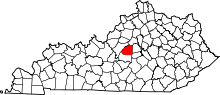 | |
| Unincorporated communities | ||