Center Township, Marion County, Indiana
| Center Township Marion County | |
|---|---|
| Township | |
 Downtown Indianapolis | |
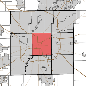 Location in Marion County | |
| Coordinates: 39°46′25″N 86°08′22″W / 39.77361°N 86.13944°WCoordinates: 39°46′25″N 86°08′22″W / 39.77361°N 86.13944°W | |
| Country |
|
| State |
|
| County | Marion |
| Government | |
| • Type | Indiana township |
| • Trustee | Eugene A. Akers |
| Area | |
| • Total | 42.7 sq mi (111 km2) |
| • Land | 41.85 sq mi (108.4 km2) |
| • Water | 0.84 sq mi (2.2 km2) 1.97% |
| Elevation | 715 ft (218 m) |
| Population (2010) | |
| • Total | 142,787 |
| • Density | 3,411.6/sq mi (1,317.2/km2) |
| ZIP codes | 46107, 46201, 46202, 46203, 46204, 46205, 46208, 46217, 46218, 46219, 46221, 46222, 46225, 46237 |
| GNIS feature ID | 0453186 |
| Website | http://centergov.org/ |
Center Township is one of nine townships in Marion County, Indiana, in the United States. As of the 2010 census, its population was 142,787 and it contained 76,872 housing units.[1] It is the most populated township in Marion County.
Center Township includes downtown Indianapolis and part of Beech Grove.
Geography
| Historical population | |||
|---|---|---|---|
| Census | Pop. | %± | |
| 1890 | 117,328 | — | |
| 1900 | 167,970 | 43.2% | |
| 1910 | 218,497 | 30.1% | |
| 1920 | 283,414 | 29.7% | |
| 1930 | 300,073 | 5.9% | |
| 1940 | 314,505 | 4.8% | |
| 1950 | 337,211 | 7.2% | |
| 1960 | 333,351 | −1.1% | |
| 1970 | 273,634 | −17.9% | |
| 1980 | 208,624 | −23.8% | |
| 1990 | 182,140 | −12.7% | |
| 2000 | 167,055 | −8.3% | |
| 2010 | 142,787 | −14.5% | |
| Est. 2013 | 146,341 | 2.5% | |
According to the 2010 census, the township has a total area of 42.7 square miles (111 km2), of which 41.85 square miles (108.4 km2) (or 98.01%) is land and 0.84 square miles (2.2 km2) (or 1.97%) is water.[1]
Communities
- Belmont at 39°45′08″N 86°11′42″W / 39.752266°N 86.194988°W
- Clifton at 39°48′58″N 86°10′59″W / 39.816153°N 86.183044°W
- Ingallston at 39°43′30″N 86°05′05″W / 39.725044°N 86.084707°W
- North Indianapolis at 39°48′28″N 86°10′41″W / 39.807820°N 86.178043°W
- Woodruff Place at 39°46′39″N 86°07′42″W / 39.777543°N 86.128319°W
Extinct communities
- Brightwood at 39°48′13″N 86°06′35″W / 39.803653°N 86.109708°W
- Clifford Park at 39°47′20″N 86°05′17″W / 39.788931°N 86.088041°W
(These towns are listed as "historical" by the USGS.)
Cemeteries
The township contains five notable cemeteries: Concordia, Crown Hill, Hebrew, Holy Cross and Saint Joseph, and New Crown.
Major highways
Airports and landing strips
- ISHC Landing Pad
- Indiana Department of Natural Resources Airport
- Indianapolis Downtown Heliport
- Methodist Hospital Helistop
Lakes
- Sullivan Lake
Notable people
- Julia Carson, former U.S. representative and onetime Center Township trustee.
- Andre Carson, current representative for Indiana's 7th congressional district grandson of Julia Carson.
School districts
- Beech Grove City Schools
- Indianapolis Public Schools
- Metropolitan School District of Perry Township
Political districts
- Indiana's 7th congressional district
- State House District 100
- State House District 86
- State House District 96
- State House District 97
- State House District 98
- State House District 99
- State Senate District 31
- State Senate District 32
- State Senate District 33
- State Senate District 34
- State Senate District 35
- State Senate District 36
References
- "Center Township, Marion County, Indiana". Geographic Names Information System. United States Geological Survey. Retrieved 2009-09-29.
- United States Census Bureau 2008 TIGER/Line Shapefiles
- IndianaMap
- 1 2 "Population, Housing Units, Area, and Density: 2010 - County -- County Subdivision and Place -- 2010 Census Summary File 1". United States Census. Retrieved 2013-05-10.
External links
- Official Website of Center Township
- Indiana Township Association
- United Township Association of Indiana
- City-Data.com page for Center Township
Places adjacent to Center Township, Marion County, Indiana | |
|---|---|
Municipalities and communities of Marion County, Indiana, United States | ||
|---|---|---|
| Excluded cities (Unigov) | ||
| Excluded town (Unigov) | ||
| Townships | ||
| Included towns (Unigov) | ||
| Footnotes | ‡ Part of Cumberland is in Hancock County. Only the portion in Marion County is subject to Unigov as an included town. | |
This article is issued from
Wikipedia.
The text is licensed under Creative Commons - Attribution - Sharealike.
Additional terms may apply for the media files.