South Oxfordshire
| South Oxfordshire District | |||
|---|---|---|---|
| Non-metropolitan district | |||
| |||
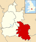 South Oxfordshire shown within Oxfordshire | |||
| Sovereign state | United Kingdom | ||
| Constituent country | England | ||
| Region | South East England | ||
| Non-metropolitan county | Oxfordshire | ||
| Historic county |
Oxfordshire (north of River Thames) Berkshire (south of River Thames) | ||
| Status | Non-metropolitan district | ||
| Admin HQ | Milton Park | ||
| Incorporated | 1 April 1974 | ||
| Government | |||
| • Type | Non-metropolitan district council | ||
| • Body | South Oxfordshire District Council | ||
| • Leadership | Jane Murphy Leader & Cabinet (Conservative) | ||
| • MPs |
John Howell Ed Vaizey | ||
| Area | |||
| • Total | 261.99 sq mi (678.54 km2) | ||
| Area rank | 55th (of 326) | ||
| Population (mid-2017 est.) | |||
| • Total | 139,800 | ||
| • Rank | 154th (of 326) | ||
| • Density | 530/sq mi (210/km2) | ||
| • Ethnicity |
95.2% White 1.7% S.Asian 1.0% Black British 1.0% Chinese or Other | ||
| Time zone | UTC0 (GMT) | ||
| • Summer (DST) | UTC+1 (BST) | ||
| ONS code |
38UD (ONS) E07000179 (GSS) | ||
| OS grid reference | SU6571895057 | ||
| Website |
www | ||
South Oxfordshire is a local government district in the ceremonial county of Oxfordshire, England. Its council is based in Milton Park, Milton. The areas located south of the River Thames are within the historic county of Berkshire.
The district was formed on 1 April 1974, under the Local Government Act 1972, from the municipal boroughs of Henley-on-Thames and Wallingford, Thame urban district, and Wallingford Rural District, Bullingdon Rural District and Henley Rural District. The Wallingford parts were previously part of the administrative county of Berkshire.
Geography
The River Thames flows for approximately 47 miles through South Oxfordshire[1], forming the historic county boundary between Berkshire and Oxfordshire. It is also joined by the River Thame within the district. A characteristic of the rivers within the district is that they have wide floodplains with few houses on them so that fluvial flooding is a lesser problem than flash flooding.[2] Towns in the district are Didcot, Henley-on-Thames, Thame, Wallingford and Watlington.
Villages
The larger villages in the district include:
Energy policy
In May 2006, a report commissioned by British Gas[3] showed that housing in South Oxfordshire produced the 5th highest average carbon emissions in the country at 7,356 kg of carbon dioxide per dwelling.
Population change and distribution
The 2001 Census recorded a population of just over 128,000 in the district. This was an increase of 7% since 1991. Much of the district is rural in nature, with the land in agricultural use and around 70% of the district has a green belt or AONB designation (The northeast of the district forms part of the Oxford Green Belt). 50% of the district’s population lives outside its four main towns of Didcot, Henley-on-Thames, Thame and Wallingford.
Governance
2015 Local Election Results[4]
| Party | Councillors | |
| Conservative Party | 33 | |
| Liberal Democrats | 1 | |
| Labour Party | 1 | |
| Henley Residents' Group | 1 | |
2015 district council office fire
On 15 January 2015, an arson attack destroyed the district council main offices in Crowmarsh Gifford.[5] As the fire started in the early hours of the morning there were no fatalities or injuries.[6] Immediately after the fire, the council was temporarily based in Abingdon, in the neighbouring Vale of White Horse district.[7] It has now moved to a semi-permanent base in Milton Park.[8] In October 2017 the Council announced that it will be returning to Crowmarsh.[9]
References
- ↑ "South Oxfordshire - River activities".
- ↑ "South Oxfordshire District Council - Floods".
- ↑ "Centrica plc - News and views" (PDF). Archived from the original (PDF) on 26 June 2008.
- ↑ 2015 election results by party
- ↑ "Video: Andrew Main sectioned after admitting South Oxfordshire council fire earlier this year". Oxford Mail.
- ↑ "South Oxfordshire District Council building on fire". BBC News. 15 January 2015.
- ↑ "Fire-hit councils' staff back at work". 10 November 2017 – via www.bbc.co.uk.
- ↑ http://www.henleystandard.co.uk/news/news.php?id=40700
- ↑ "South Oxfordshire District Council is coming home to Crowmarsh - South Oxfordshire District Council". www.southoxon.gov.uk.
External links
Oxfordshire Portal | |
| Boroughs or districts | |
| Major settlements | |
| Topics | |