South Carolina Highway 51
| ||||
|---|---|---|---|---|
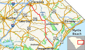 Map of the Georgetown-Florence segment of SC 51 | ||||
| Route information | ||||
| Maintained by SCDOT | ||||
| Existed | 1926 – present | |||
| Georgetown–Florence segment | ||||
| Length | 69.64 mi[1] (112.07 km) | |||
| South end |
| |||
| Major junctions | ||||
| North end |
| |||
| York segment | ||||
| Length | 1.01 mi[1] (1.63 km) | |||
| South end |
| |||
| North end |
| |||
| Location | ||||
| Counties | Georgetown, Williamsburg, Florence, York | |||
| Highway system | ||||
| ||||

South Carolina Highway 51 (SC 51) is a primary state highway in the U.S. state of South Carolina. It is unique for having two segments, which are separated by over one hundred miles (160 km) from each other. The first segment, traveling north–south, connects the cities of Georgetown and Florence, via the towns of Hemingway, Johnsonville and Pamplico. The second segment, near Fort Mill, is a reciprocated continuation of North Carolina Highway 51 (NC 51) from the North Carolina state line to U.S. Route 21 (US 21).
Route description
The main segment of SC 51 begins at US 701, just north of Georgetown. Traveling at a northwesterly direction, along Browns Ferry Road, it merges onto SC 41 in Rhems. For the next 2.3 miles (3.7 km), SC 41/SC 51 straddle the county line between Georgetown and Williamsburg counties, before breaking off towards Hemingway, near Rome Crossroads. Connecting with SC 261 in Hemingway, it soon enters Florence County and Johnsonville. Continuing north, it changes from traveling along SC 41 to US 378 in Kingsburg and continues west. After 3.5 miles (5.6 km), it splits from US 378 in Salem, traveling northwest along Pamplico Highway towards Pamplico and finally Florence. In Florence, SC 51 connects with US 301 (Freedom Boulevard) and US 52 (Irby Street); it then travels west along Second Loop Road to US 76 where it ends. The majority of the route is a two-lane rural road through mostly swamp and farmland. Around Hemingway and Florence, the route expands to four lanes and has a median.[2][3][4][5]
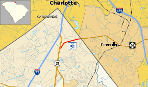
The York County segment of SC 51 is a short one-mile (1.6 km) road that starts at US 21 near Fort Mill and ends at the North Carolina state line, where it continues on as NC 51 through Pineville. The route is entirely two-lane, expanding to four lanes at the state line.[6][7]
History
Established as a new primary routing in 1926; the original routing ran from SC 40 (today as US 701) along Choppee Road (today as S-22-4) and Hemingway Highway (today as SC 261) to Hemingway then onto Florence, ending at SC 41 (today as US 52). The route was fully paved by 1939. In the early 1960s, the SC 51 was rerouted as a concurrency with SC 41 from Hemingway to Rhems, then to US 701 near Georgetown. In 1978, SC 51 was extended along Second Loop Road, in Florence, to US 76.[8][9][10][11][12][13]
The York County segment of SC 51 was established in 1969. In the prior year, US 21 was rerouted northwest onto a new freeway route into North Carolina and its old alignment through Pineville was replaced by an extension of NC 51 to the state line. South Carolina reciprocated with SC 51, keeping the route number consistent across the border.[14][15]
Junction list
| County | Location | mi[1] | km | Destinations | Notes | ||
|---|---|---|---|---|---|---|---|
| Georgetown | | 0.00 | 0.00 | ||||
| Williamsburg | Rhems | 15.77 | 25.38 | South end of SC 41 overlap | |||
| | 18.13 | 29.18 | Southern terminus of SC 513 | ||||
| Rome Crossroads | 19.33 | 31.11 | |||||
| Hemingway | 26.94 | 43.36 | |||||
| Florence | Johnsonville | 31.51 | 50.71 | Eastern terminus of SC 341 | |||
| Kingsburg | 36.06 | 58.03 | North end of SC 41 and east end of US 378 overlaps | ||||
| Salem | 39.34 | 63.31 | West end of US 378 overlap | ||||
| Evergreen | 57.08 | 91.86 | North end of SC 327 overlap | ||||
| 57.22 | 92.09 | South end of SC 327 overlap | |||||
| Florence | 65.40 | 105.25 | |||||
| 65.97 | 106.17 | ||||||
| 69.64 | 112.07 | ||||||
| Gap in route | |||||||
| York | | 0.00 | 0.00 | ||||
| | 1.01 | 1.63 | Continuation into North Carolina | ||||
1.000 mi = 1.609 km; 1.000 km = 0.621 mi
| |||||||
References
- 1 2 3 "Statewide Highways (shapefile)" (zip). South Carolina Department of Transportation. September 29, 2017. Retrieved December 8, 2017.
- ↑ General Highway System, Georgetown County, South Carolina (PDF) (Map). Cartography by SCDOT. Columbia: South Carolina Department of Transportation. July 2016. Retrieved July 11, 2017.
- ↑ General Highway System, Williamsburg County, South Carolina (PDF) (Map). Cartography by SCDOT. Columbia: South Carolina Department of Transportation. April 2016. Retrieved July 11, 2017.
- ↑ General Highway System, Florence County, South Carolina (PDF) (Map). Cartography by SCDOT. Columbia: South Carolina Department of Transportation. March 2016. Retrieved July 11, 2017.
- ↑ Google (August 29, 2014). "South Carolina Highway 51: Georgetown–Florence Segment" (Map). Google Maps. Google. Retrieved August 29, 2014.
- ↑ General Highway System, York County, South Carolina (PDF) (Map). Cartography by SCDOT. Columbia: South Carolina Department of Transportation. February 2016. Retrieved July 11, 2017.
- ↑ Google (February 1, 2011). "South Carolina Highway 51: York Segment" (Map). Google Maps. Google. Retrieved February 1, 2011.
- ↑ General Highway and Transportation Map, Georgetown County, South Carolina (Map). Cartography by SCSHD. Columbia: South Carolina State Highway Department. June 1953 [1939]. Retrieved July 11, 2017 – via University of South Carolina.
- ↑ General Highway Map, Georgetown County, South Carolina (Map). Cartography by SCSHD. Columbia: South Carolina State Highway Department. July 1963 [1955]. Retrieved July 11, 2017 – via University of South Carolina.
- ↑ General Highway and Transportation Map, Williamsburg County, South Carolina (Map). Cartography by SCSHD. Columbia: South Carolina State Highway Department. July 1939. Retrieved July 11, 2017 – via University of South Carolina.
- ↑ General Highway Map, Williamsburg County, South Carolina (Map). Cartography by SCSHD. Columbia: South Carolina State Highway Department. May 1963 [1955]. Retrieved July 11, 2017 – via University of South Carolina.
- ↑ General Highway and Transportation Map, Florence County, South Carolina (Map). Cartography by SCSHD. Columbia: South Carolina State Highway Department. May 1940 [1938]. Retrieved July 11, 2017 – via University of South Carolina.
- ↑ General Highway and Transportation Map, Florence County, South Carolina (Map). Cartography by SCDHPT. Columbia: South Carolina Department of Transportation and Highway Safety. March 1986 [1973]. Retrieved July 11, 2017 – via University of South Carolina.
- ↑ General Highway Map, York County, South Carolina (Map). Cartography by SCSHD. Columbia: South Carolina State Highway Department. August 1967 [1961]. Retrieved July 11, 2017 – via University of South Carolina.
- ↑ General Highway Map, York County, South Carolina (Map). Cartography by SCSHD. Columbia: South Carolina State Highway Department. May 1970 [1961]. Retrieved July 11, 2017 – via University of South Carolina.
External links

- Mapmikey's South Carolina Highways Page: SC 51