Solo, Arkansas
| Solo, Arkansas | |
|---|---|
| Unincorporated community | |
 Solo, Arkansas Position in Arkansas | |
| Coordinates: 35°35′14″N 92°57′49″W / 35.58722°N 92.96361°WCoordinates: 35°35′14″N 92°57′49″W / 35.58722°N 92.96361°W | |
| Country |
|
| State |
|
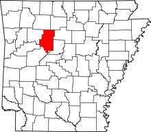
| County | Pope |
| Elevation | 500 m (1,640 ft) |
| Time zone | UTC-6 (Central (CST)) |
| • Summer (DST) | UTC-5 (CDT) |
| GNIS feature ID | 73640 |
Solo is an unincorporated community in the Ozark National Forest, Pope County, Arkansas, United States.[1]
References
This article is issued from
Wikipedia.
The text is licensed under Creative Commons - Attribution - Sharealike.
Additional terms may apply for the media files.