Galla Township, Pope County, Arkansas
| Galla Township | |
|---|---|
| Township | |
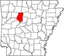
 Galla Township Location in Arkansas | |
| Coordinates: 35°13′15″N 93°02′46″W / 35.22083°N 93.04611°WCoordinates: 35°13′15″N 93°02′46″W / 35.22083°N 93.04611°W | |
| Country |
|
| State |
|
| County | Pope |
| Area | |
| • Total | 41.57 sq mi (107.7 km2) |
| • Land | 39.87 sq mi (103.3 km2) |
| • Water | 1.7 sq mi (4 km2) |
| Elevation | 344 ft (105 m) |
| Population (2010) | |
| • Total | 4,681 |
| • Density | 117.4/sq mi (45.3/km2) |
| Time zone | UTC-6 (CST) |
| • Summer (DST) | UTC-5 (CDT) |
| Zip Code |
72858 (Pottsville) 72801 (Russellville) |
| Area code(s) | 479 |
| GNIS feature ID | 69704 |
Galla Township is one of nineteen current townships in Pope County, Arkansas, USA.[1] As of the 2010 census, its total population was 4,681.
Geography
According to the United States Census Bureau, Galla Township covers an area of 41.57 square miles (107.7 km2); 39.87 square miles (103.3 km2) of land and 1.7 square miles (4.4 km2) of water.
Cities, towns, and villages
- Pottsville (part)
- Russellville (part)
References
- United States Census Bureau 2008 TIGER/Line Shapefiles
- United States Board on Geographic Names (GNIS)
- United States National Atlas
- ↑ "Galla Township, Pope County, Arkansas." U.S. Census Bureau. Breakdown. Retrieved June 20, 2010.
External links
This article is issued from
Wikipedia.
The text is licensed under Creative Commons - Attribution - Sharealike.
Additional terms may apply for the media files.