Griffin Township, Pope County, Arkansas
| Griffin Township | |
|---|---|
| Township | |
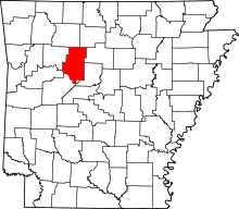
 Griffin Township Location in Arkansas | |
| Coordinates: 35°25′30″N 92°52′36″W / 35.42500°N 92.87667°WCoordinates: 35°25′30″N 92°52′36″W / 35.42500°N 92.87667°W | |
| Country |
|
| State |
|
| County | Pope |
| Established | 1854[1] |
| Area | |
| • Total | 34.09 sq mi (88.3 km2) |
| • Land | 33.94 sq mi (87.9 km2) |
| • Water | 0.15 sq mi (0.4 km2) |
| Elevation | 502 ft (153 m) |
| Population (2010) | |
| • Total | 839 |
| • Density | 24.7/sq mi (9.5/km2) |
| Time zone | UTC-6 (CST) |
| • Summer (DST) | UTC-5 (CDT) |
| Zip code | 72822 (Appleton) |
| Area code(s) | 479 |
| GNIS feature ID | 69705 |
Griffin Township is one of nineteen current townships in Pope County, Arkansas, USA.[2] As of the 2010 census, its total population was 839.
Geography
According to the United States Census Bureau, Griffin Township covers an area of 34.09 square miles (88.3 km2); 33.94 square miles (87.9 km2) of land and 0.15 square miles (0.39 km2) of water.
Cities, towns, and villages
References
- United States Census Bureau 2008 TIGER/Line Shapefiles
- United States Board on Geographic Names (GNIS)
- United States National Atlas
- ↑ Baker, Russell (2003). Arkansas Township Atlas 1819-1930. Little Rock, AR: Arkansas Genealogical Society. p. 148. ISBN 0-9723085-6-3.
- ↑ "Griffin Township, Pope County, Arkansas." U.S. Census Bureau. Breakdown. Retrieved June 20, 2010.
External links
This article is issued from
Wikipedia.
The text is licensed under Creative Commons - Attribution - Sharealike.
Additional terms may apply for the media files.