Buttermilk, Arkansas
| Buttermilk, Arkansas | |
|---|---|
| Unincorporated community | |
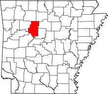
 Buttermilk, Arkansas Buttermilk's position in Arkansas.  Buttermilk, Arkansas Buttermilk, Arkansas (the US) | |
| Coordinates: 35°23′14″N 92°53′50″W / 35.38722°N 92.89722°WCoordinates: 35°23′14″N 92°53′50″W / 35.38722°N 92.89722°W | |
| Country |
|
| State |
|
| County | Pope County, Arkansas |
| Elevation | 127 m (417 ft) |
| Time zone | UTC-6 (Central (CST)) |
| • Summer (DST) | UTC-5 (CDT) |
| GNIS feature ID | 70941 |
Buttermilk is an unincorporated community in Pope County, Arkansas, United States.[1] The community's name was derived from an observer who saw the whitewash run off the Cumberland Presbyterian Church during a rain storm in 1840 and commented that it looked like buttermilk.[2]
References
- ↑ "Feature Detail Report for: Buttermilk, Arkansas." USGS. Profile. Retrieved June 23, 2010.
- ↑ Deane, Ernie (1986). Arkansas Place Names. Branson, Missouri: The Ozarks Mountaineer. p. 94.
This article is issued from
Wikipedia.
The text is licensed under Creative Commons - Attribution - Sharealike.
Additional terms may apply for the media files.