Sivaslı
| Sivaslı | |
|---|---|
| District | |
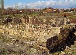 Ruins of the ancient city of Sebaste near Sivaslı | |
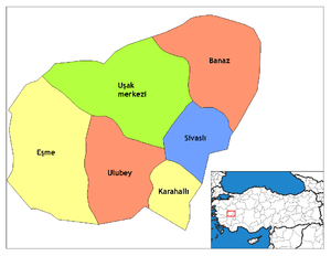 Location of Sivaslı within Uşak Province. | |
 Sivaslı Location of Sivaslı within Uşak Province. | |
| Coordinates: 38°29′N 29°41′E / 38.483°N 29.683°ECoordinates: 38°29′N 29°41′E / 38.483°N 29.683°E | |
| Country |
|
| Region | Aegean |
| Province | Uşak |
| Government | |
| • Mayor | Nihat Sazligol (CHP) |
| Area[1] | |
| • District | 506.47 km2 (195.55 sq mi) |
| Elevation | 1,050 m (3,440 ft) |
| Population (2012)[2] | |
| • Urban | 6,696 |
| • District | 21,366 |
| • District density | 42/km2 (110/sq mi) |
| Time zone | UTC+3 (EET) |
| • Summer (DST) | UTC+3 (EEST) |
| Licence plate | 64 |
| Website |
Sivaslı Municipality Prefecture of Sivaslı |
Sivaslı, formerly known as Sebaste (Greek: Σεβαστείας, Sebasten) is a town and district of Uşak . Province in the inner Aegean region of Turkey. Sebaste ancient city area is 2 km (1.2 mi) away from Sivaslı town center today.
The ancient city of Sebaste was founded by Roman Emperor Augustus (reigned 27 BC–AD 14) under the name "City of Sebaste" and was the 12th most important city of Roman Empire. In the 9th century around, the city turned into a regional bishop seat. In the period of East Roman Empire, when two churches were constructed for the bishops.
References
- ↑ "Area of regions (including lakes), km²". Regional Statistics Database. Turkish Statistical Institute. 2002. Retrieved 2013-03-05.
- ↑ "Population of province/district centers and towns/villages by districts - 2012". Address Based Population Registration System (ABPRS) Database. Turkish Statistical Institute. Retrieved 2013-02-27.
External links
- A web site about Sivaslı
- A photograph of the town
- A collection of photographs of the ruins of Sebaste
- Falling Rain Genomics, Inc. "Geographical information on Sivaslı, Turkey". Retrieved 2008-10-26.
| Wikimedia Commons has media related to Sivaslı. |
This article is issued from
Wikipedia.
The text is licensed under Creative Commons - Attribution - Sharealike.
Additional terms may apply for the media files.