Karahallı
| Karahalli | |
|---|---|
| District | |
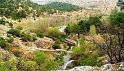
 Ancient Cılandıras Bridge over Banaz Stream near Karahallı | |
 Location of Karahallı within Uşak Province. | |
 Karahalli Location of Karahallı within Uşak Province. | |
| Coordinates: 38°19′N 29°31′E / 38.317°N 29.517°ECoordinates: 38°19′N 29°31′E / 38.317°N 29.517°E | |
| Country |
|
| Region | Aegean |
| Province | Uşak |
| Government | |
| • Mayor | Nihat Süzek (CHP) |
| Area[1] | |
| • District | 336.85 km2 (130.06 sq mi) |
| Elevation | 873 m (2,864 ft) |
| Population (12,500)[2] | |
| • Urban | 10,000 |
| • | 12,500 |
| • Density | 37/km2 (96/sq mi) |
| Time zone | UTC+3 (EET) |
| • Summer (DST) | UTC+3 (EEST) |
| Licence plate | 64 |
| Website |
Karahallı Municipality Prefecture of Karahallı |
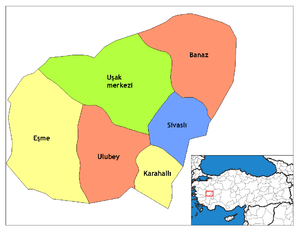
Karahallı is a town and district of Uşak Province in the inner Aegean region of Turkey. Karahallı district area neighbors those of two other districts of the same province to the north, namely Ulubey and Sivaslı, and to the south those of two districts depending Denizli Province which are Çivril and Bekilli.
Karahallı center is at a distance of 62 km (39 mi) from the province center of Uşak lying to its north. The district has fourteen depending villages, namely; Alfaklar, Buğdaylı, Beki, Çoğuplu, Çokaklı, Delihıdırlı, Dumanlı, Duraklı, Külköy, Kaykıllı, Kırkyaren, Kavaklı, Karayakuplu and Paşalar.
The district area is crossed by Banaz Stream and is divided roughly equally between agricultural lands and woodland, mostly oaks.
The name of the town makes reference to its founder, the 14th century Turkmen bey Kara Halil. The township was made into a district in 1953, simultaneous to the separation of Uşak Province from Kütahya Province, and Uşak's becoming a province seat.
There is a recently built dam and its reservoir, which is arranged into a recreational area that stands out notably by the presence of an ancient bridge, possibly associated with the Lydians and the Persians, and the Royal Road, although research specific to the bridge is yet to be made. It is built over Banaz Stream (Banaz Çayı) which later joins Büyük Menderes River and the locality is called Clandras or Klandras.
The ancient site of Pepuza, proclaimed as new Jerusalem in the traditions of Montanism, sometimes referred to as the lost sect of Christianity (mid-2nd century) is located within the boundaries of Karahallı district, and is an important visitor's attraction.
Another important ancient construction is Cılandıras Bridge over Banaz Stream.
In Ottoman times, the township was an important center for textile products, made especially of wool woven following Turkish traditions. Weaving activity is still pursued in an intensive manner with the presence of more than a thousand electric power looms across the district.
Cultivation of grapes intended for production of wine in the nearby center of Bekilli is also an important economic activity.
The region of Karahallı experienced considerable levels of outside immigration in recent decades, both towards other centers of its region and towards Europe. People who originate in Karahallı and live outside the district now outnumber those living in Karahallı.
Among notable natives is Azra Akın, Miss World in 2002, herself born in the Netherlands, but whose father, the former Eskişehirspor player Nazmi Akın, is from Karahallı.
See also
References
- ↑ "Area of regions (including lakes), km²". Regional Statistics Database. Turkish Statistical Institute. 2002. Retrieved 2013-03-05.
- ↑ "Population of province/district centers and towns/villages by districts - 2012". Address Based Population Registration System (ABPRS) Database. Turkish Statistical Institute. Retrieved 2013-02-27.
| Wikimedia Commons has media related to Karahallı. |