Beaver County, Alberta
| Beaver County | ||
|---|---|---|
| Municipal district | ||
| ||
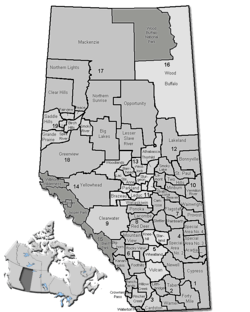 Location of Beaver County in Alberta | ||
| Coordinates: 53°15′N 112°14′W / 53.250°N 112.233°WCoordinates: 53°15′N 112°14′W / 53.250°N 112.233°W | ||
| Country |
| |
| Province |
| |
| Region | Central Alberta | |
| Census division | No. 10 | |
| Established | 1943 | |
| Incorporated | 1958 | |
| Government[1] | ||
| • Reeve | Jim Kallal | |
| • Governing body |
Beaver County Council
| |
| • CAO | Robert Beck | |
| • Office location | Ryley | |
| Area (2016)[2] | ||
| • Land | 3,317.57 km2 (1,280.92 sq mi) | |
| Population (2016)[2] | ||
| • Total | 5,905 | |
| • Density | 1.8/km2 (5/sq mi) | |
| Time zone | UTC-7 (MST) | |
| • Summer (DST) | UTC-6 (MDT) | |
| Postal code span | T0B | |
| Website | beaver.ab.ca | |
Beaver County is a municipal district in central-east Alberta, Canada. It is centred on Holden in the western part of Census Division No. 10. Its municipal office is located in Ryley.
Beaver County was incorporated as a municipal district on July 31, 1999, and the name was changed from "County of Beaver No. 9" to "Beaver County".[3]
Demographics
In the 2016 Census of Population conducted by Statistics Canada, Beaver County recorded a population of 5,905 living in 2,177 of its 2,381 total private dwellings, a 3.8% change from its 2011 population of 5,689. With a land area of 3,317.57 km2 (1,280.92 sq mi), it had a population density of 1.8/km2 (4.6/sq mi) in 2016.[2]
In the 2011 Census, Beaver County had a population of 5,689 living in 2,109 of its 2,324 total dwellings, a 0.2% change from its 2006 population of 5,676. With a land area of 3,315.84 km2 (1,280.25 sq mi), it had a population density of 1.7/km2 (4.4/sq mi) in 2011.[4]
In 2009, Beaver County had a population of 5,630 living in 2,291 dwellings.[5]
Communities and localities
|
The following urban municipalities are surrounded by Beaver County:[6]
The following hamlets are located within Beaver County:[6]
|
The following localities are located within Beaver County:[7]
|
Attractions
Two parks with campgrounds are located in the county's limits, Black Nugget Lake (located between Tofield and Ryley, south of Highway 14) and Camp Lake (located east of Viking, between Kinsella and Innisfree).
See also
References
- ↑ "Municipal Officials Search". Alberta Municipal Affairs. 2017-09-22. Retrieved 2017-09-25.
- 1 2 3 "Population and dwelling counts, for Canada, provinces and territories, and census subdivisions (municipalities), 2016 and 2011 censuses – 100% data (Alberta)". Statistics Canada. February 8, 2017. Retrieved February 8, 2017.
- ↑ Beaver County municipal profile - Alberta Municipal Affairs
- ↑ "Population and dwelling counts, for Canada, provinces and territories, and census subdivisions (municipalities), 2011 and 2006 censuses (Alberta)". Statistics Canada. February 8, 2012. Retrieved February 8, 2012.
- ↑ "Municipal Census Highlights" (PDF). Beaver County. 2009. Archived from the original (PDF) on February 26, 2012. Retrieved July 29, 2010.
- 1 2 "Specialized and Rural Municipalities and Their Communities" (PDF). Alberta Municipal Affairs. 2012-03-01. Retrieved 2012-08-11.
- ↑ "Standard Geographical Classification (SGC) 2006, Economic Regions: 4810016 - Beaver County, geographical codes and localities, 2006". Statistics Canada. 2010-03-05. Retrieved 2012-08-11.
External links
| Wikimedia Commons has media related to Beaver County, Alberta. |
Places adjacent to Beaver County, Alberta | |
|---|---|