County of Newell
| County of Newell | ||
|---|---|---|
| Municipal district | ||
 | ||
| ||
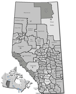 Location of Newell County in Alberta | ||
| Coordinates: 50°33′51″N 111°53′56″W / 50.56417°N 111.89889°WCoordinates: 50°33′51″N 111°53′56″W / 50.56417°N 111.89889°W | ||
| Country |
| |
| Province |
| |
| Region | Southern Alberta | |
| Census division | No. 2 | |
| Established | 1948 | |
| Incorporated | 1953 | |
| Government[1] | ||
| • Reeve | Molly Douglass | |
| • Governing body | County of Newell Council | |
| • Office location | south of Brooks | |
| Area (2016)[2] | ||
| • Land | 5,904.67 km2 (2,279.81 sq mi) | |
| Population (2016)[2] | ||
| • Total | 7,524 | |
| • Density | 1.3/km2 (3/sq mi) | |
| Time zone | UTC-7 (MST) | |
| Website | countyofnewell.ab.ca | |
The County of Newell is a municipal district in southern Alberta, Canada. Located in Census Division No. 2, its municipal office is located south of the City of Brooks.
History
It was incorporated as the County of Newell No. 4 on January 1, 1953, through the amalgamation of the Municipal District of Newell No. 28 and part of the Municipal District of Bow Valley No. 40. Its name was changed to the County of Newell on September 9, 2011.[3]
Demographics
In the 2016 Census of Population conducted by Statistics Canada, the County of Newell recorded a population of 7,524 living in 2,412 of its 2,627 total private dwellings, a 5.4% change from its 2011 population of 7,138. With a land area of 5,904.67 km2 (2,279.81 sq mi), it had a population density of 1.3/km2 (3.3/sq mi) in 2016.[2]
In the 2011 Census, the County of Newell had a population of 6,786 living in 2,220 of its 2,480 total dwellings, a -1% change from its 2006 adjusted population of 6,852. With a land area of 5,904.72 km2 (2,279.83 sq mi), it had a population density of 1.1/km2 (3.0/sq mi) in 2011.[4] Following the 2013 dissolution of the Village of Tilly, Statistics Canada adjusted the County of Newell's 2011 population upward by 352 people to 7,138.[5]
The population of the County of Newell according to its 2009 municipal census is 7,101.[6]
Communities and localities
|
The following urban municipalities are surrounded by the County of Newell:[7][8]
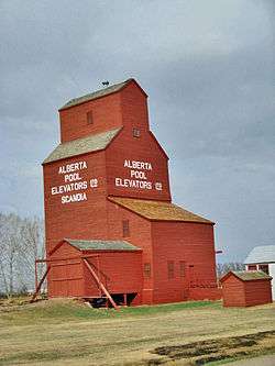
The following hamlets are located within the County of Newell:[8]
|
The following localities are located within the County of Newell:[9]
|
See also
References
- ↑ "Municipal Officials Search". Alberta Municipal Affairs. September 22, 2017. Retrieved September 25, 2017.
- 1 2 3 "Population and dwelling counts, for Canada, provinces and territories, and census subdivisions (municipalities), 2016 and 2011 censuses – 100% data (Alberta)". Statistics Canada. February 8, 2017. Retrieved February 8, 2017.
- ↑ "O.C. 417/2011". Province of Alberta. 2011-09-09. Retrieved 2011-09-13.
- ↑ "Population and dwelling counts, for Canada, provinces and territories, and census subdivisions (municipalities), 2011 and 2006 censuses (Alberta)". Statistics Canada. February 8, 2012. Retrieved February 8, 2012.
- ↑ "Interim List of Changes to Municipal Boundaries, Status, and Names From January 2, 2013 to January 1, 2014 (Table 1 – Changes to census subdivisions in alphabetical order by province and territory)" (XLSX). Statistics Canada. May 21, 2014. Retrieved May 29, 2014.
- ↑ "Alberta 2009 Official Population List" (PDF). Alberta Municipal Affairs. September 15, 2009. Retrieved September 12, 2010.
- ↑ "Brooks, City (Census Subdivision), Alberta". Statistics Canada. 2012-06-20. Retrieved 2012-08-13.
- 1 2 "Specialized and Rural Municipalities and Their Communities" (PDF). Alberta Municipal Affairs. August 30, 2013. Retrieved September 2, 2013.
- ↑ "Standard Geographical Classification (SGC) 2006, Economic Regions: 4802031 - Newell County No. 4, geographical codes and localities, 2006". Statistics Canada. 2010-03-05. Retrieved 2012-08-11.
External links
Places adjacent to County of Newell | |
|---|---|