Special Area No. 4
| Special Area No. 4 | |
|---|---|
| Special area | |
| Nickname(s): Special Area 4 | |
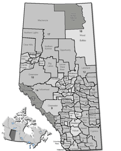 Location of Special Area No. 4 in Alberta | |
| Coordinates: 52°00′N 110°36′W / 52.0°N 110.6°WCoordinates: 52°00′N 110°36′W / 52.0°N 110.6°W | |
| Country |
|
| Province |
|
| Region | Central Alberta |
| Census division | No. 4 |
| Incorporated | January 1, 1969[1] |
| Government | |
| • Governing body | Special Areas Board |
| • Municipal office | Hanna |
| • District office | Consort |
| Area (2016)[2] | |
| • Land | 6,625.58 km2 (2,558.15 sq mi) |
| Population (2016)[2] | |
| • Total | 1,042 |
| • Density | 0.2/km2 (0.5/sq mi) |
| Time zone | UTC-7 (MST) |
| • Summer (DST) | UTC-6 (MDT) |
| Postal Code Prefix | T0C |
| Area code | +1-403 |
| Website | specialareas.ab.ca |
Special Area No. 4 is a special area in central Alberta, Canada. It is a rural municipality similar to a municipal district, however, the elected council is overseen by four representatives appointed by the province, the Special Areas Board.
Special Area 4 has one provincial park, Gooseberry Lake Provincial Park. Lakes include Grassy Island Lake and Sounding Lake.
Demographics
In the 2016 Census of Population conducted by Statistics Canada, Special Area No. 3 recorded a population of 1,042 living in 387 of its 457 total private dwellings, a change of −7.1% from its 2011 population of 1,122. With a land area of 6,625.58 km2 (2,558.15 sq mi), it had a population density of 0.2/km2 (0.4/sq mi) in 2016.[2]
In the 2011 Census, Special Area No. 4 had a population of 1,352 living in 447 of its 501 total dwellings, a change of -2.7% from its 2006 population of 1,389. With a land area of 4,403.03 km2 (1,700.02 sq mi), it had a population density of 0.3/km2 (0.8/sq mi) in 2011.[3]
Communities and localities
|
The following urban municipalities are surrounded by Special Area No. 4:[4]
The following hamlets are located within Special Area No. 4:[4]
|
The following localities are located within Special Area No. 4:[5]
|
References
- ↑ "Municipal Profile: Special Areas Board" (PDF) (PDF). Alberta Municipal Affairs. October 24, 2014. p. 1. Retrieved November 3, 2014.
- 1 2 3 "Population and dwelling counts, for Canada, provinces and territories, and census subdivisions (municipalities), 2016 and 2011 censuses – 100% data (Alberta)". Statistics Canada. February 8, 2017. Retrieved February 8, 2017.
- ↑ "Population and dwelling counts, for Canada, provinces and territories, and census subdivisions (municipalities), 2011 and 2006 censuses (Alberta)". Statistics Canada. 2012-02-08. Retrieved 2012-02-08.
- 1 2 "Specialized and Rural Municipalities and Their Communities" (PDF). Alberta Municipal Affairs. 2012-03-01. Retrieved 2012-08-12.
- ↑ "Standard Geographical Classification (SGC) 2006, Economic Regions: 4804020 - Special Area No. 4, geographical codes and localities, 2006". Statistics Canada. 2010-03-05. Retrieved 2012-08-12.
Places adjacent to Special Area No. 4 | |
|---|---|