Mangnang Monastery
| Mangnang Monastery | |
|---|---|
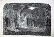 Mangnang Monastery in 1866 | |
| Basic information | |
| Location | Ngari Prefecture, Tibet |
| Geographic coordinates | 31°21′3.6″N 79°47′13.2″E / 31.351000°N 79.787000°ECoordinates: 31°21′3.6″N 79°47′13.2″E / 31.351000°N 79.787000°E |
Mangnang Monastery was a Buddhist monastery in western Tibet. Founded in the 11th century, it was visited by the British in 1866, who photographed it. The photographs are now part of the Royal Geographical Society. The monastery was probably destroyed in 1959.
| Part of a series on |
| Tibetan Buddhism |
|---|
 |
|
|
Practices and attainment |
|
Institutional roles |
|
History and overview |
|
|
This article is issued from
Wikipedia.
The text is licensed under Creative Commons - Attribution - Sharealike.
Additional terms may apply for the media files.