Sheho
| Sheho | |
|---|---|
| Village | |
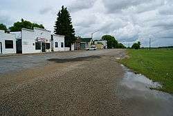 Main Street | |
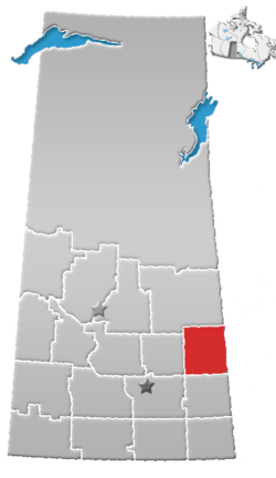
 Location of Sheho, in Saskatchewan  Sheho (Canada) | |
| Coordinates: 51°35′0″N 103°13′0″W / 51.58333°N 103.21667°W | |
| Country | Canada |
| Province | Saskatchewan |
| Rural Municipalities (R.M.) | Sheho No. 341, Saskatchewan |
| Post office Founded Sheho Lake | 1891-11-01 |
| Post office name change to Sheho | 1892-09-01 |
| Area | |
| • Total | 1.95 km2 (0.75 sq mi) |
| • Density | 62.0/km2 (161/sq mi) |
| [1][2][3][4] | |
Sheho, Saskatchewan is a village in the Canadian province of Saskatchewan. Sheho is located on Saskatchewan Highway 16, the Yellowhead in south east Saskatchewan between Foam Lake and the city of Yorkton.[5] Sheho Lake post office first opened in 1891 at the legal land description of Sec.28, Twp.30, R.9, W2 before moving slightly and changing name to Sheho.[6] Sheho is located east of Foam Lake, Saskatchewan and west of Yorkton, Saskatchewan
Demographics
| Canada census – Sheho community profile | |||
|---|---|---|---|
| 2006 | |||
| Population: | 121 (-18.2% from 2001) | ||
| Land area: | 1.95 km2 (0.75 sq mi) | ||
| Population density: | 62.0/km2 (161/sq mi) | ||
| Median age: | 61.5 (M: 62.5, F: 61.2) | ||
| Total private dwellings: | 118 | ||
| Median household income: | $N/A | ||
| References: 2006[7] earlier[8] | |||
- N/A = Data Not Available
Area statistics
- Lat (DMS) 51° 35' 00" N
- Long (DMS) 103° 13' 00" W
- Dominion Land Survey NE Sec.9, Twp.30, R.9, W2
- Time zone (cst) UTC-6
Location
Places adjacent to Sheho | ||||||||||
|---|---|---|---|---|---|---|---|---|---|---|
| ||||||||||
See also
Notes and references
- ↑ National Archives, Archivia Net, Post Offices and Postmasters
- ↑ Government of Saskatchewan, MRD Home, Municipal Directory System, archived from the original on November 21, 2008
- ↑ Canadian Textiles Institute. (2005), CTI Determine your provincial constituency
- ↑ Commissioner of Canada Elections, Chief Electoral Officer of Canada (2005), Elections Canada On-line
- 1 2 Adamson, J, Rand McNally 1924 Saskatchewan Map, retrieved 2008-03-26
- ↑ National Archives, Archivia Net, Post Offices and Postmasters, retrieved 2008-03-26
- ↑ "2006 Community Profiles". Canada 2006 Census. Statistics Canada. March 30, 2011. Retrieved 2009-02-24.
- ↑ "2001 Community Profiles". Canada 2001 Census. Statistics Canada. February 17, 2012.
External links
| Wikimedia Commons has media related to Sheho, Saskatchewan. |
- Saskatchewan City & Town Maps
- Saskatchewan Gen Web - One Room School Project
- Post Offices and Postmasters - ArchiviaNet - Library and Archives Canada
- Saskatchewan Gen Web Region
- Online Historical Map Digitization Project
- GeoNames Query
- 2006 Community Profiles
Coordinates: 51°35′13″N 103°12′45″W / 51.58694°N 103.21250°W
This article is issued from
Wikipedia.
The text is licensed under Creative Commons - Attribution - Sharealike.
Additional terms may apply for the media files.