Division No. 9, Saskatchewan
| Division No. 9 | |
|---|---|
| Census division in Saskatchewan | |
| Country |
|
| Province |
|
| Area | |
| • Total | 15,281.80 km2 (5,900.34 sq mi) |
| As of 2016 | |
| Population (2016) | |
| • Total | 35,634 |
| • Density | 2.3/km2 (6.0/sq mi) |
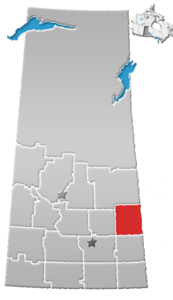
Division No. 9, Canada, is one of the eighteen census divisions within the province of Saskatchewan, as defined by Statistics Canada. It is located in the eastern part of the province, bordering Manitoba. The most populous community in this division is Yorkton.
Demographics
In the 2016 Census, Division 9 had a population of 35,634 living in 15,297 of its 18,041 total dwellings, a 0.9% increase from its 2011 population of 35,314. With a land area of 15,281.80 km² it had a population density of 2.3 people per square kilometre in 2016[1].
Census subdivisions
The following census subdivisions (municipalities or municipal equivalents) are located within Saskatchewan's Division No. 9.
Cities
Towns
Villages
Rural municipalities
|
Indian reserves
- Cote First Nation
- Cote 64
- Keeseekoose First Nation
- Keeseekoose 66
- Keeseekoose 66A
- Keeseekoose 66-CA-04
- Keeseekoose 66-CA-05
- Keeseekoose 66-CA-06
- Keeseekoose 66-KE-04
- Keeseekoose 66-KE-05
- The Key First Nation
- The Key 65
See also
References
- ↑ "Population and dwelling counts, for Canada, provinces and territories, and census divisions, 2011 and 2016 censuses (Saskatchewan)". Statistics Canada.
- 1 2 Statistics Canada. 2002 2001 Community Profiles. Released June 27, 2002. Last modified: 2005-11-30. Statistics Canada Catalogue no. 93F0053XIE. Page accessed January 5, 2007
- Division No. 9, Saskatchewan Statistics Canada
Places adjacent to Division No. 9, Saskatchewan | ||||||||||
|---|---|---|---|---|---|---|---|---|---|---|
| ||||||||||
| Subdivisions | |
|---|---|
| Communities | |
| Cities | |
| Census divisions | |
| Topics |
|
| |
Coordinates: 51°34′12″N 101°54′00″W / 51.57000°N 101.90000°W
This article is issued from
Wikipedia.
The text is licensed under Creative Commons - Attribution - Sharealike.
Additional terms may apply for the media files.