Arran, Saskatchewan
| Arran | |
|---|---|
| Village | |
| Village of Arran | |
 Location of Arran in Saskatchewan  Arran, Saskatchewan (Canada) | |
| Coordinates: 51°31′49″N 101°25′51″W / 51.5304°N 101.4307°W | |
| Country | Canada |
| Province | Saskatchewan |
| Region | Southeastern |
| Census division | 9 |
| Rural Municipality | Livingston |
| Government | |
| • Type | Arran Village Council |
| • Mayor | Rick Nahnybida |
| Population (2011) | |
| • Total | 140 |
| • Density | 124.7/km2 (323/sq mi) |
| Time zone | CST |
| Postal code | S0A 0B0 |
| Area code(s) | 306 |
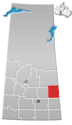
Arran (2011 population 40) is a village within the Rural Municipality of Livingston No. 331, Saskatchewan, Canada. The village is approximately 90 km northeast of the city of Yorkton and 10 km west of the Manitoba border. Arran is located on Highway 49.
The village was named after the Isle of Arran in Scotland.[1]
History
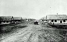
The area around Arran was part of the "North Reserve", also known as "Thunder Hill Reserve", one of the block settlement areas allocated for the Doukhobor immigrants who arrived here in 1899 from Russia's Transcaucasian provinces. [2]
A commemorative plaque marking the closure of Arran School at the end of the 1994 class year reads:[3]
ARRAN SCHOOL
NO. 3480
SEC. SE. 1-34-31 BUILT - NOV. 1914CLOSED - JUNE 1994
A similar sign is posted in front of the school, reading:[4]
ARRAN, NO. 3480
first opened-Nov.30, 1914
Closed-June 30, 1994S.E. sec. 1·34·21·W. 1st
Historic sites
- Ukrainian Orthodox Church of Ascension,[5] 9.5 kilometres southeast of Arran.
Demographics
| Canada census – Arran, Saskatchewan community profile | |||
|---|---|---|---|
| 2011 | 2006 | ||
| Population: | 40 (0.0%% from 2006) | 40 (-27.3%% from 2001) | |
| Land area: | 0.69 km2 (0.27 sq mi) | 0.69 km2 (0.27 sq mi) | |
| Population density: | 58.2/km2 (151/sq mi) | 58.2/km2 (151/sq mi) | |
| Median age: | 43.5 (M: 39.5, F: 46.5) | 55.2 (M: 53.5, F: 55.8) | |
| Total private dwellings: | 31 | 30 | |
| Median household income: | $Not Available | $Not Available | |
| References: 2011[6] 2006[7] earlier[8] | |||
Climate
| Climate data for Arran | |||||||||||||
|---|---|---|---|---|---|---|---|---|---|---|---|---|---|
| Month | Jan | Feb | Mar | Apr | May | Jun | Jul | Aug | Sep | Oct | Nov | Dec | Year |
| Record high °C (°F) | 7.2 (45) |
12.5 (54.5) |
13 (55) |
28.9 (84) |
38.5 (101.3) |
36.5 (97.7) |
36.5 (97.7) |
36.1 (97) |
35 (95) |
29 (84) |
18.3 (64.9) |
7 (45) |
38.5 (101.3) |
| Average high °C (°F) | −12.5 (9.5) |
−9.1 (15.6) |
−2.3 (27.9) |
8 (46) |
17.7 (63.9) |
22.1 (71.8) |
23.9 (75) |
22.9 (73.2) |
16.2 (61.2) |
8.8 (47.8) |
−3 (27) |
−11.3 (11.7) |
6.8 (44.2) |
| Daily mean °C (°F) | −18.4 (−1.1) |
−15.3 (4.5) |
−8.4 (16.9) |
1.9 (35.4) |
10.4 (50.7) |
15 (59) |
17.1 (62.8) |
15.8 (60.4) |
9.7 (49.5) |
3.2 (37.8) |
−7.6 (18.3) |
−16.6 (2.1) |
0.6 (33.1) |
| Average low °C (°F) | −24.2 (−11.6) |
−21.4 (−6.5) |
−14.4 (6.1) |
−4.2 (24.4) |
3 (37) |
7.8 (46) |
10.3 (50.5) |
8.7 (47.7) |
3.2 (37.8) |
−2.5 (27.5) |
−12.1 (10.2) |
−21.8 (−7.2) |
−5.6 (21.9) |
| Record low °C (°F) | −43.9 (−47) |
−44.5 (−48.1) |
−38.5 (−37.3) |
−30 (−22) |
−10 (14) |
−5 (23) |
0 (32) |
−2 (28) |
−8.9 (16) |
−23 (−9) |
−37 (−35) |
−44 (−47) |
−44.5 (−48.1) |
| Average precipitation mm (inches) | 19.1 (0.752) |
15.7 (0.618) |
26.4 (1.039) |
30.8 (1.213) |
40.5 (1.594) |
73.1 (2.878) |
77.6 (3.055) |
63.4 (2.496) |
55.9 (2.201) |
25.6 (1.008) |
20.1 (0.791) |
19.9 (0.783) |
468 (18.43) |
| Source: Environment Canada[9] | |||||||||||||
See also
References
- ↑ Barry, Bill (September 2005). Geographic Names of Saskatchewan. Regina, Saskatchewan: People Places Publishing, Ltd. p. 25. ISBN 1-897010-19-2.
- ↑ J.J. Kalmakoff Historical Doukhobor Maps - Saskatchewan Archived 2012-02-04 at the Wayback Machine.
- ↑ Closure plaque
- ↑ Closure sign
- ↑ Ukrainian Orthodox Church of Ascension Archived March 12, 2016, at the Wayback Machine. - Historic Register of Canada
- ↑ "2011 Community Profiles". Canada 2011 Census. Statistics Canada. July 5, 2013. Retrieved 2009-02-24.
- ↑ "2006 Community Profiles". Canada 2006 Census. Statistics Canada. March 30, 2011. Retrieved 2009-02-24.
- ↑ "2001 Community Profiles". Canada 2001 Census. Statistics Canada. February 17, 2012.
- ↑ Environment Canada Canadian Climate Normals 1971–2000, accessed 23 July 2010
External links
Places adjacent to Arran, Saskatchewan | ||||||||||
|---|---|---|---|---|---|---|---|---|---|---|
| ||||||||||
| Subdivisions | |
|---|---|
| Communities | |
| Cities | |
| Topics |
|
| |
Coordinates: 51°53′04″N 101°43′07″W / 51.88444°N 101.71861°W