Sheet Harbour, Nova Scotia
| Sheet Harbour | |
|---|---|
| Rural Community | |
 West River Falls, where the West River empties into the Northwest Arm. | |
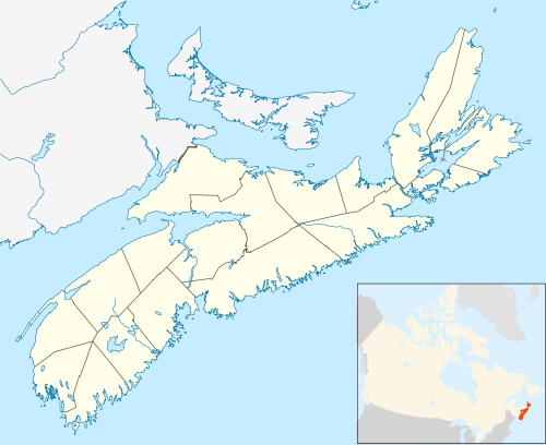 Sheet Harbour Location within Nova Scotia | |
| Coordinates: 44°55′N 62°32′W / 44.917°N 62.533°WCoordinates: 44°55′N 62°32′W / 44.917°N 62.533°W | |
| Country |
|
| Province |
|
| Municipality | Halifax Regional Municipality |
| District | 1 |
| Founded | 1784 |
| Government | |
| • Type | Regional Council |
| • Governing Council | Halifax Regional Council |
| • Community Council | Marine Drive Valley and Canal |
| Area | |
| • Total | 188.38 km2 (72.73 sq mi) |
| Highest elevation | 114 m (374 ft) |
| Lowest elevation | 0 m (0 ft) |
| Population | |
| • Total | 800 |
| • Density | 4.24/km2 (10.99/sq mi) |
| Time zone | UTC-4 (AST) |
| • Summer (DST) | UTC-3 (ADT) |
| Canadian Postal code | B0J 3B0 |
| Telephone Exchanges | 902 885 |
| GNBC Code | CBIKA |
| Highways |
|
| Website |
sheetharbour |
| Part of a series about Places in Nova Scotia | |
Sheet Harbour is a rural community on the Eastern Shore of Nova Scotia, Canada. It is part of the Halifax Regional Municipality and lies along the Marine Drive on Trunk 7 approximately 117 kilometres (73 mi) northeast of Halifax. The catchment area around the community contains approximately 5,000 people. The community is located along the shores of Sheet Harbour, which has two arms: the Northwest Arm and the Northeast Arm. Two rivers flow into the harbour: West River into the Northwest Arm, and East River into the Northeast Arm. Little West River, a minor river, also flows into the Northwest Arm. Grand Lake, a large lake west of Sheet Harbour, empties into the Atlantic Ocean, via the Little West River. Adjacent to the community is the Sheet Harbour Industrial Port, an important regional deep-water port. The majority of the land was granted in 1773 and the colony was established in 1784. Forestry was prominent in Sheet Harbour during its early years. The first sulphide pulp mill in the Dominion of Canada was constructed along the East River in 1885. However, it was closed in 1891, due to the high prices of importing sulphide. Another pulp mill was constructed beside the West River Falls in 1925, but it was destroyed by Hurricane Beth in August 1971. The community today relies on forestry, fishing and tourism.
Trunk 7 runs directly through Sheet Harbour. Route 224 and Route 374 both have junctions in Sheet Harbour. A new bridge was built across the Northeast Arm, and was named the East River Bridge, after its predecessor. Construction started in September 2014 and it was opened on 17 December 2015, with a bridge walk to commemorate the event. Sheet Harbour has a hospital, named Eastern Shore Memorial Hospital (ESMH), which is connected to Harbourview Lodge. The community is located about ten minutes northeast of Taylor Head Provincial Park. Sheet Harbour has one school: Duncan MacMillan High School (DMHS). There is a plan currently underway by the Halifax Regional School Board to replace the four schools in the Sheet Harbour area, two of which are defunct and under demolition, respectively, with one P-12 school. Tom McInnis, a former Conservative Party politician and member of the Nova Scotia House of Assembly from 1978-1993, resides in Sheet Harbour.[1]
Location
Sheet Harbour is a small rural community located on the Eastern Shore of Nova Scotia, in the eastern area of the Halifax Regional Municipality.[2] The catchment area around the community includes approximately 5,500 people.[3] Sheet Harbour is located slightly more northward compared to other coastal communities in the area, due to the shape of the harbour. The population of Census Tract 2050154.00, which includes Sheet Harbour and a large amount of land around Sheet Harbour's land borders, is 3,478 as of the 2011 Canadian Census.[4] Census tracts are small subdivisions of land that are used for statistics gathering by Statistics Canada that usually have a population of 2,500 to 8,000. Each census tract has a numerical designation.[5] The population of the community of Sheet Harbour is about 800.[6] Immediately west of Sheet Harbour is Sheet Harbour 36, a small Mi'kmaq reserve.[7]
Topography
The community of Sheet Harbour is located along the shores of Sheet Harbour, a saltwater harbour which has two arms: The Northwest Arm and the Northeast Arm.[8][9][10]
The western and the wider arm is referred to as the Northwest Arm, while the eastern arm is known as the Northeast Arm. The two arms connect just below Church Point, southeast of where West River meets the Northwest Arm. The harbour continues southeast-ward, then southward toward the Atlantic Ocean. The Northwest Arm extends northwest until it meets the mouth of West River at the West River Falls.[9] The Northeast Arm extends north, then curves northeast under the East River Bridge, until it meets the mouth of the East River.[8][10] There is a very small island in the arm, named Hen Island.[11] Moorings were installed in the arm in Spring 2017.[12]
The harbour from Church Point, where the two arms meet,[13] to the Atlantic Ocean is referred to as Sheet Harbour. It is wider than either arm. It is approximately 11-15 metres (36-49 ft) deep at low tide.[14] It gradually widens as it flows southward the Atlantic Ocean. After Church Point, it flows southeast-ward past the Sheet Harbour Industrial Port and west of the small community of Watt Section. It then curves and flows southwest-ward to southward toward the Atlantic.[8][15]
The area around Sheet Harbour is heavily forested and rich in lakes.[16] The coastline is also very rocky and eroded by the Atlantic Ocean, as is typical with most of the Eastern Shore.[17] Sheet Harbour has average tides of about 1.2 to 1.5 m (4 to 5 ft).[18]
Rivers
Two major rivers, one minor river and several small streams empty into the harbour. West River flows into the Northwest Arm, and East River empties into the Northeast Arm.[19][20][21]
Northwest Arm
West River, formally West River Sheet Harbour, begins near Beaver Dam, Nova Scotia. The main branch of the river, named West River Main, is 30 kilometres (19 mi) long.[22] The river has two secondary branches, the Killag River, which is 27 kilometres (17 mi) long, and Little River, which is 16.5 kilometres (10.3 mi) long.[22] Several smaller streams flow into the river as it progresses southeast-ward toward Sheet Harbour. Lake Alma flows into West River via Little River.[22] A while downstream, the river flows into Sheet Harbour Lake. Sheet Harbour Lake ends just before the West River Bridge, where Trunk 7 passes over the West River, just before the West River Falls. The falls carry water from 22 metres (72 ft) elevation down to sea level. The river then empties into the Northwest Arm.[20] The river area has been deforested and is prone to flash-flooding.[22]
Sheet Harbour was the first community in North America to use a lime doser,[6][23] which sprays limestone into the water, to lower acid rain levels, starting in September 2005 in the West River. It was successful in stabilizing the pH of the river at 5.5, a healthy level for salmon and other aquatic life.[22]
The Grand Lake, a large lake west of Sheet Harbour, also empties into the Northwest Arm via West Lake and Little West River in West Sheet Harbour.[19] The river empties into West Cove, then into the Northwest Arm.[24]
Northeast Arm
East River, formally East River Sheet Harbour, is the other main river that discharges into Sheet Harbour. It flows through the Marshall Flowage, a large flowage,[25] then past the Ruth Falls Power Plant, a hydropower generating station. It narrows back into a river for a short while, then flows into the head of the Northeast Arm.[21][26]
History
Almost all of the present land area of Sheet Harbour was granted in 1773,[27] and the settlement was established around 1784,[27] by Loyalist refugees and British veterans of the American Revolution and became a prosperous centre for the lumber industry. The Mi'kmaq name for the settlement was Weijooik, which translates to "flowing wildly". Sheet Harbour was named "Port North" on the Royal Navy Chart that was published in 1778. In January 1805, the ship Salisbury was wrecked off of Sheet Harbour and nine of the crew were lost. [28] The settlement was called Port North until 1807. Alternate names for the settlement were Campbelltown and Manchester.[27] Campbelltown would have been named after Lord William Campbell, who was a Captain General as well as a Governor-in-Chief from 1776–73.[27] It was decided that "Port North" was not descriptive enough, so the name was changed to Sheet Harbour, starting in 1818 because of a white, flat rock that looks like a sheet, named Sheet Rock;[27] the rock is located at the entrance of the harbour.[29]
Around 1863, a sawmill was built at the tide head of the East River Sheet Harbour, by Demming and McFarlane, a lumber company. However, they did not succeed financially, and they dissolved a few years later.[30]
In October 1885, the Halifax Wood Fibre Company built the first sulphide pulp mill in Canada, which at the time was the Dominion of Canada, at East River, Sheet Harbour.[8] Since the discovery of the sulphite process happened earlier in 1866, the news had traveled to William Chisholm, who was a lumber manufacturer in Halifax. He decided to try the sulphite method out for himself at the head of the East River. He had 60,000 acres (24,281 hectares, or 242 km2) of woodland on the Sheet Harbour rivers.[31] The mill closed in January 1891, due to the high costs of importing sulphide from the United States.[32] The cookhouse which was used at the mill was bought by the residents of Watt Section and was floated down the harbour to the community.[33]
In 1922, a ground-wood pulp mill, owned by the American Pulp and Wrapping Paper Co. of Albany, began operation on the West River at the head of the Northwest Arm of Sheet Harbour. They had purchased it from Rhodes and Currie, the previous owners who were a lumber company. It produced its first ground-wood pulp on October 5, 1925.[34][35] It remained in operation until it was destroyed by Hurricane Beth in August 1971.[36][37]
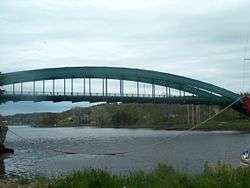
A steel arch bridge was built in the 1950s over the Northeast Arm. It was named the East River Bridge. It was replaced by a new bridge with the same name in December 2015.[38] Sheet Harbour Consolidated School, an elementary school, was built in 1957. It was closed in 2017, as part of the plan to consolidate four schools in the area into one new, larger school.[39]
Industry
The economy of Sheet Harbour is primarily based on fishery and forestry, as well as tourism, to a lesser extent.[40]
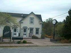
Sheet Harbour has a Chamber of Commerce. The SHCOC was formed in 1935, and were formerly known as the Sheet Harbour Board of Trade.[41][42] They comprise more than 25 of the businesses in the Sheet Harbour area and they also operate a Visitor Information Centre at the MacPhee House, situated on the site of the ground-wood pulp mill just east of the West River Bridge, where Trunk 7 crosses the West River at the entrance to Sheet Harbour. There is a community museum at the MacPhee House and they have a collection interpreting "Life before plastic".[43]
In the 1990s, the Government of Nova Scotia built a common user deep water dock and industrial park just west of Sheet Harbour, named the Sheet Harbour Industrial Port. It is currently operated by the Halifax Port Authority. It currently ships wood chips for the pulp industry and imports wind turbine segments, which are then transported across Nova Scotia and to the rest of North America. The port was used to service the Sable Offshore Energy Project with natural gas pipes processed at coating plant therefore making them suitable for placement on the ocean floor. The port is the closest marine terminal to the fields, at a distance of 240 kilometres (150 mi).[14] It is also approximately 80 kilometres (50 mi) west of the Great Circle Route, a major shipping route between North America and Europe.[14] The docking area is 152 metres (499 ft) long and 36.5 metres (120 ft) wide. It also has 10.3 metres (34 ft) of draft, which is connected to a concrete pad.[44]
Transportation
The community is situated at the junction of Route 374 and Route 224 with Trunk 7. There is no major public transit service in the community. The community has sidewalks that run from West River Bridge to East River Bridge, through the main part of Sheet Harbour. They were opened in 2010. [45] and cost approximately $2,900,000 (US$2,400,000)[46]
2014–15 East River Bridge replacement
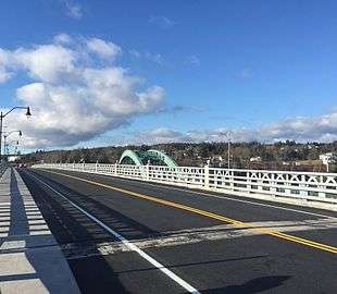
A new bridge was built across the Northeast Arm from September 2014 to December 2015, to replace the East River Bridge.[38]
The bridge was built because the previous bridge, built in 1956, was nearing the end of its life span. The Nova Scotia Government had proposed minor repairs, but it was decided by the N.S. Government that an entirely new bridge would be more cost-effective.[38] The new bridge was designed, unlike its predecessor, without large, overhead steel arches, because it would have been twice as costly to build.[47] The new bridge was constructed on the same site as the old bridge's predecessor which was constructed just south of the East River Bridge in 1907.[47]
The bridge cost $19,000,000 (US$14,671,644) to build and construction began in September 2014.[38] The contractor, Dexter Construction, poured 2,260 cubic metres (79,811 cubic feet) of concrete over 650,000 kg (1,430,000 lb) of rebar. The new bridge relies on two pillars set in the granite below the Northeast Arm. When it was near completion in December 2015, a deck, along with railings and sidewalks, were laid.[47] The bridge was opened on 17 December 2015 to pedestrians and opened the next day to traffic.[48]
There were also a few road modifications on the Sheet Harbour side of the bridge as a result of the new bridge. Trunk 7 was aligned with what was Riverside Drive, which is now nonexistent. Church Point Road and Pool Road were slightly modified. The access road to Sheet Harbour Consolidated School and Duncan MacMillan High School was slightly modified. Sprott Lane, a minor loop, was extended along a part of the old Trunk 7 for a few households.[38]
Shortly after the new bridge was opened, the old East River Bridge was closed and was demolished through 2016.[38]
Amenities
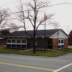
Sheet Harbour has a Home Hardware store[49] an NSLC liquor store[50] a post office, run by Canada Post,[51] a public library, which is owned and operated by Halifax Public Libraries,[52] a convenience store, a small park,[35] a takeout, a police station, which is run by the Royal Canadian Mounted Police,[3] a fire station,[53] and three churches. Sheet Harbour also has a Ground Search and Rescue[54], and also hosts one apartment building, two gas stations, operated by Irving Oil and Wilson Fuel, who run the Wilsons Gas Stops chain of gas stations, respectively,[55] a Foodland grocery store[56] and two banks, operated by Scotiabank[57] and Credit Union[58] respectively. The Sheet Harbour Industrial Port is located five minutes west of Sheet Harbour. It is run by the Halifax Port Authority.[44] Sheet Harbour has two motels: Fairwinds Motel and Restaurant[59] and the Sheet Harbour Motel.[60] There is a campground located along the East River, named East River Lodge Campground and Trailer Park.[61] Moorings were installed in the Northwest Arm in Spring 2017.[12]
Eastern Shore Cartage serves Sheet Harbour and its surroundings.[62] Watts Wind Energy, Inc. built a wind turbine in Watt Section, a small community immediately east of Sheet Harbour, in 2010. It was the outcome of favourable wind data that was obtained by a meteorological tower near what would be the site of the wind turbine. It was constructed and was producing power by October 2011. It stands 85 metres (279 ft) tall and produces about 1.5 MW of power which powers approximately 375 households.[63]
Every August, the "Seaside Festival" is hosted by the local Lions Club.[64]
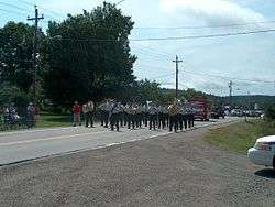
The 2610 Royal Canadian Army Cadet Corps is based in Sheet Harbour. They were originally formed on 1 October 1957, but were disbanded on 31 December 1973. Twelve years later, the corps was reformed on 1 February 1985 and is still active today. They have won the Strathcona cup, an award that is given to the best performing cadet corps in Nova Scotia, five times.[65]
Eastern Shore Memorial Hospital is a hospital located in Sheet Harbour. Construction began in 1947, and was opened on May 24, 1949.[66] It is owned and operated by the Capital District Health Authority, which amalgamated into the Nova Scotia Health Authority in 2015.[67] It has sixteen beds for patients. There is a cenotaph and gardens in front of the site where Duncan MacMillan Nursing Home (DMNH) once stood. The hospital offers quite a few services. It is connected to Harbourview Lodge, a nursing home, by a corridor. Harbourview Lodge was built in 2011 to replace DMNH, which was nearing the end of its life span.[68]
Just ten minutes west of Sheet Harbour on Trunk 7 in Spry Bay is Taylor Head Provincial Park. It has two beaches. The entire park is located on a peninsula which juts out into the Atlantic Ocean. Hunting and firearms are forbidden in the park. The park contains over 22 km (14 mi) of hiking trails, and over a kilometre (0.62 mi.) of beach. The park is open from May–October each year.[17] Near, but outside of the park, is the Spry Bay Campground. It is also located in Spry Bay.[69] Also in Spry Bay is a Dept. of Transportation and Public Works, owned and operated by the Nova Scotia Government.[70]
Education
There is one school in Sheet Harbour: Duncan MacMillan High School (DMHS).[71]

DMHS is the only school in Sheet Harbour, and the only high school in the Sheet Harbour area. The school was built in 1963. It has one feeder school, Lakefront Consolidated School (LCS), which is located in Tangier.[72] The school offers Integrated French for all grades and teaches grades seven through twelve. As of 2017, there are 241 students enrolled at DMHS.[71]
Sheet Harbour Consolidated School (SHCS) was an elementary school in the community. It was built in 1957, and served grades primary through six. It was closed in 2017 and is being demolished as part of a plan to consolidate the three schools in the area into one that will be built on the site of DMHS.[73]
Since December 2013, a plan has been underway for the Halifax Regional School Board to close and demolish at least two of the three DMHS feeder schools, as well as DMHS itself, and replace them with a larger, more modern school in Sheet Harbour, that will serve grades primary-12. This new school will teach about 300 students and will serve the large area around Sheet Harbour.[74][75] On 26 April 2016, the site for the project was chosen; the site that Duncan MacMillan High School currently occupies. A school steering team was established thereafter and cooperates with the design team for the new school, the Halifax Regional School Board and two government departments; the Department of Transportation and Infrastructure Renewal and the Department of Education and Early Childhood Development for the design and planning phases.[76][75]
Places adjacent to Sheet Harbour, Nova Scotia | |
|---|---|
Notable residents
- Tom McInnis, former Conservative Party politician and member of the Nova Scotia House of Assembly from 1978-1993[1]
See also
References
Notes
- 1 2 "Thomas Johnson McInnis - Conservative Party of Canada". Parliament of Canada. Retrieved 27 October 2015.
- ↑ "Explore HRM". Halifax Regional Municipality. Archived from the original on 15 January 2013. Retrieved 22 March 2016.
- 1 2 "RCMP Sheet Harbour Detachment". Royal Canadian Mounted Police. Retrieved 30 September 2015.
- ↑ "Census Profile". Statistics Canada. Retrieved 12 August 2015.
- ↑ "Census tract (CT)". Statistics Canada. Retrieved 22 March 2016.
- 1 2 "Sheet Harbour". Sheet Harbour Chamber of Commerce & Civic Affairs. Retrieved 17 October 2015.
- ↑ "Census Profile - Map : Sheet Harbour 36, Indian reserve (Census Subdivision), Nova Scotia". Statistics Canada. Retrieved 26 October 2015.
- 1 2 3 4 Coady 1988, p. 14-15.
- 1 2 "Northwest Arm". Natural Resources Canada. Retrieved 17 April 2016.
- 1 2 "Northeast Arm". Natural Resources Canada. Retrieved 17 April 2016.
- ↑ "Hen Island". Natural Resources Canada. Retrieved 17 April 2016.
- 1 2 "Moorings in the Harbour". Sheet Harbour Chamber of Commerce & Civic Affairs. Retrieved 18 August 2017.
- ↑ "Sheet Harbour Lake". Natural Resources Canada. Retrieved 4 June 2016.
- 1 2 3 "Business Development". Sheet Harbour Chamber of Commerce. Retrieved 30 May 2015.
- ↑ "Sheet Harbour". Natural Resources Canada. Retrieved 17 April 2016.
- ↑ "Tangier Grand Lake Wilderness Area". Nova Scotia Government. Retrieved 31 October 2015.
- 1 2 "Taylor Head Provincial Park" (PDF). Nova Scotia Provincial Parks. Retrieved 12 August 2015.
- ↑ "Sheet Harbour Tide Chart". Meteo365.com Ltd. Retrieved 22 November 2015.
- 1 2 "Little West River". Natural Resources Canada. Retrieved 4 October 2015.
- 1 2 "West River Sheet Harbour". Natural Resources Canada. Retrieved 24 March 2016.
- 1 2 "East River Sheet Harbour". Natural Resources Canada. Retrieved 24 March 2016.
- 1 2 3 4 5 "Assessment of the 2009 West River, Sheet Harbour Atlantic salmon smolt migration" (PDF). Nova Scotia Salmon Association. p. 5. Retrieved 30 November 2015.
- ↑ "West River Sheet Harbour - lime doser support". The Atlantic Salmon Conservation Foundation. Retrieved 17 October 2015.
- ↑ "West Cove". Natural Resources Canada. Retrieved 18 April 2016.
- ↑ "East River Sheet Harbour". Natural Resources Canada. Retrieved 24 March 2016.
- ↑ Coady, Howard. Sheet Harbour History. Lancelot Press Limited. pp. 14–15. ISBN 0-88999-381-5.
- 1 2 3 4 5 Scott, David. Nova Scotia Place Names. DESPUB. pp. 235–236. ISBN 978-0-9865370-1-1.
- ↑ Naval Chronicles, Vol. 14, p. 263
- ↑ "Sheet Rock Light". Marinas.com. Retrieved 2 October 2015.
- ↑ Coady 1988, p. 8.
- ↑ Coady 1988, p. 16-17.
- ↑ Coady 1988, p. 22.
- ↑ Coady 1988, p. 23.
- ↑ Coady 1988, p. 54-55.
- 1 2 "Sheet Harbour" (PDF). Nova Scotia Government. Retrieved 7 October 2015.
- ↑ Coady 1988, p. 64.
- ↑ "Sheet Harbour Waterfront Site Plan: Final Report" (PDF). Ekistics Planning & Design. Retrieved 7 October 2015.
- 1 2 3 4 5 6 "East River Bridge Replacement Project". Nova Scotia Department of Transportation and Infrastructure Renewal. Retrieved 13 November 2015.
- ↑ "Government Investing in Schools". Province of Nova Scotia. Retrieved 19 August 2017.
- ↑ "The Sheet Harbour, Nova Scotia Business Case" (PDF). Greater Halifax Partnership. p. 5. Retrieved 22 March 2016.
- ↑ Coady 1988, p. 104.
- ↑ "Welcome". Sheet Harbour Chamber of Commerce. Retrieved 6 October 2015.
- ↑ "MacPhee House Community Museum". Nova Scotia Department of Tourism. Retrieved 7 October 2015.
- 1 2 "Port of Sheet Harbour & Industrial Park". Nova Scotia Business Inc. Archived from the original on 29 September 2015. Retrieved 18 August 2015.
- ↑ "Grand Opening Sheet Harbour Sidewalk Streetscape Project". Sheet Harbour Chamber of Commerce. 20 October 2012. Retrieved 30 September 2015.
- ↑ "Revised Area Rate and Project Funding for Sheet Harbour Streetscape Phase 1" (PDF). Halifax Regional Municipality. 1 February 2011. Retrieved 30 September 2015.
- 1 2 3 Beswick, Aaron (18 December 2014). "East River bridge project on track". The Chronicle Herald. Truro, Nova Scotia. Retrieved 2 December 2015.
- ↑ "Sheet Harbour Residents Celebrate New East River Bridge". Nova Scotia Department of Transportation and Infrastructure Renewal. 17 December 2015. Retrieved 19 December 2015.
- ↑ "Gammon Brothers Home Hardware Building Centre". Home Hardware Inc. Retrieved 30 September 2015.
- ↑ "Sheet Harbour NSLC". Nova Scotia Liquor Corporation. Retrieved 30 September 2015.
- ↑ "CanadaPost - Post Office: SHEET HARBOUR PO, Nova Scotia (mail, package delivery, courier) - Location & Hours". mystore411. Retrieved 30 September 2015.
- ↑ "Sheet Harbour Public Library". Halifax Public Libraries. Retrieved 30 September 2015.
- ↑ "Fire Stations". Halifax Regional Fire & Emergency. Retrieved 30 September 2015.
- ↑ "Sheet Harbour & Area Ground Search & Rescue". Sheet Harbour & Area Ground Search & Rescue. Retrieved 30 September 2015.
- ↑ "Irving". yellowpages.ca. Retrieved 30 September 2015.
- ↑ "Foodland in Sheet Harbour - Store Details". StoreLocate.ca. Retrieved 30 September 2015.
- ↑ "Scotiabank". yellowpages.ca. Retrieved 30 September 2015.
- ↑ "East Coast Credit Union – Sheet Harbour Branch". Credit Unions Atlantic Canada. Retrieved 30 September 2015.
- ↑ "Fairwinds Motel & Restaurant Nova Scotia". Fairwinds. Retrieved 30 September 2015.
- ↑ "Sheet Harbour Motel & Restaurant". yellowpages.ca. Retrieved 30 September 2015.
- ↑ "East River Lodge Campground & Trailer Park". Nova Scotia Department of Tourism. Retrieved 30 September 2015.
- ↑ "Eastern Shore Cartage". Eastern Shore Cartage. Retrieved 30 October 2015.
- ↑ "The Watts Wind project". Watts Wind Inc. Retrieved 12 August 2015.
- ↑ "Lions Club Sheet Harbour Seaside Festival". Seaside Tourism Business Association. Retrieved 22 March 2016.
- ↑ "#2610 Cadet Corps". Sheet Harbour Army Cadet Corps #2610. Retrieved 5 October 2015.
- ↑ Coady 1988, p. 111-12.
- ↑ Laroche, Jean (29 September 2014). "Nova Scotia health authorities merger explained". Retrieved 15 January 2016.
- ↑ "Eastern Shore Memorial Hospital". Nova Scotia Health Authority. Retrieved 16 September 2015.
- ↑ "Spry Bay Campground & Cabins". Retrieved 5 October 2015.
- ↑ "Area Offices". Nova Scotia Department of Transportation. Retrieved 30 September 2015.
- 1 2 "Duncan MacMillan High". Halifax Regional School Board. Retrieved 17 September 2015.
- ↑ "Lakefront Consolidated Elementary". Halifax Regional School Board. Retrieved 8 February 2016.
- ↑ "Sheet Harbour Consolidated Elementary". Halifax Regional School Board. Retrieved 17 September 2015.
- ↑ "School Review Committee Response - Sheet Harbour Consolidated Elementary - January 2013" (PDF). Halifax Regional School Board. Retrieved 12 August 2015.
- 1 2 "New Eastern District P-12". Halifax Regional School Board. Retrieved 19 August 2017.
- ↑ "Government Announces Site for New School". Province of Nova Scotia. Retrieved 26 April 2016.
Bibliography
Scott, David (2011). Nova Scotia Place Names. DESPUB. ISBN 978-0-9865370-1-1.
Coady, Howard (1988). Sheet Harbour History. Lancelot Press Limited. ISBN 0-88999-381-5.
External links
| Wikimedia Commons has media related to Category:Sheet Harbour. |
- Sheet Harbour Chamber of Commerce website
- Community website
- Sheet Harbour Ancestry website
- Tourist attractions
- East River Bridge replacement article
- DMHS Website
- SHCS Website
| Government | |
|---|---|
| Services and agencies | |
| Articles of interest | |
| Education | |
| Major neighbourhoods & communities |
|
| |