Sandusky, Ohio
| Sandusky, Ohio | ||
|---|---|---|
| City | ||
 | ||
| ||
 Location in the state of Ohio | ||
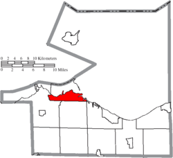 Location of Sandusky in Erie County | ||
| Coordinates: 41°26′48″N 82°42′33″W / 41.44667°N 82.70917°WCoordinates: 41°26′48″N 82°42′33″W / 41.44667°N 82.70917°W | ||
| Country | United States | |
| State | Ohio | |
| County | Erie | |
| Founded | 1816 | |
| Government[1] | ||
| • Type | City Commission | |
| • President | Dennis Murray (D) | |
| • Vice President | Richard Brady | |
| • Commissioners |
Nikki Lloyd Greg Lockhart C. Wesley Poole Naomi R. Twine Dave Waddington | |
| Area[2] | ||
| • City | 21.91 sq mi (56.75 km2) | |
| • Land | 9.73 sq mi (25.20 km2) | |
| • Water | 12.18 sq mi (31.55 km2) | |
| Elevation | 597 ft (182 m) | |
| Population (2010)[3] | ||
| • City | 25,793 | |
| • Estimate (2014[4]) | 25,346 | |
| • Density | 2,606/sq mi (1,006.2/km2) | |
| • Metro | 77,079 | |
| Time zone | UTC-5 (EST) | |
| • Summer (DST) | UTC-4 (EDT) | |
| ZIP codes | 44870-44871 | |
| Area code(s) | 419/567 | |
| FIPS code | 39-70380[5] | |
| GNIS feature ID | 1076832[6] | |
| Website |
www | |

Sandusky /sændʌskiː/ is a city in the U.S. state of Ohio and the county seat of Erie County.[7] Situated in northern Ohio on the shores of Lake Erie, Sandusky is midway between Toledo to the west and Cleveland to the east.
According to 2010 census, the city had a population of 25,793,[8] and the Sandusky, Ohio Micropolitan Statistical Area had 77,079 residents.[9]
In 2011, Sandusky was ranked No. 1 by Forbes as the "Best Place to Live Cheaply" in the United States.[10] The city has a median family income of $64,000.[10]
Sandusky is home to the Cedar Fair Entertainment Company and its flagship amusement park, Cedar Point. Cedar Point has one of the largest collections of roller coasters in the world.[11] Cedar Point includes 17 roller coasters.[12] It is home to the second tallest roller coaster in the world, the Top Thrill Dragster.
The National Arbor Day Foundation has designated Sandusky as a Tree City USA.
Etymology
The accepted etymology is that the name "Sandusky" is derived from the Wyandot word saundustee, meaning "water"[13] or andusti, "cold water".[14] In his 1734 history of New France, Charlevoix transliterated the word as "Chinouski". Sandusky Bay is identified as "Lac (Lake) Sandouské" on a 1718 map by Guillaume DeLisle.[15] The name "L.(Lac) Sandoski" appears on a 1733 map.[16] Sandusky Bay was also called Lac Ondaské, in another French transliteration of the Wyandot.[17]
It was used as the name of an English trading post on the north side of the bay, a French Fort Sandoské that replaced it, a British Fort Sandusky on the south shore of the bay, and an American Fort Sandusky upriver at what is now Fremont; the fort was renamed as Fort Stephenson.[17]
History
This area was been a center of trading and fortifications since the 18th century: the English, French, and Americans had trading posts and forts built on both the north and south sides of Sandusky Bay.[17]
Development by European Americans of the city of Sandusky, starting in 1818, on the southeast shore of Sandusky Bay, followed settlement of the war of 1812. Part of the city quickly enveloped the site of an earlier small village named "Portland" (established about 1816). Eventually the city of Sandusky encompassed most of the entire township that had been called Portland.[18] Some of the city was built on land formerly occupied by a Native-American man named Ogontz, and therefore the city is said to have been built on "Ogontz' place".
Prior to the abolition of slavery in the United States, Sandusky was a major stop for refugee slaves on the Underground Railroad, as some would travel across Lake Erie to reach freedom in Canada. Although Ohio was a free state, they felt at risk from slavecatchers because of bonuses offered under the Fugitive Slave Act of 1850. As depicted in Harriet Beecher Stowe's novel Uncle Tom's Cabin (1855), many refugee slaves seeking to get to Canada made their way to Sandusky, where they boarded boats crossing Lake Erie to the port of Amherstburg in Ontario.
Downtown Sandusky was designed according to a modified grid plan, known as the Kilbourne Plat after its designer. Hector Kilbourne was a surveyor who laid out this grid in downtown Sandusky. He became the first Worshipful Master of the first Sandusky Masonic Lodge known as Science Lodge #50. It is still in operation on Wayne Street. His original street plan featured a grid overlaid with streets in patterns to resemble the symbols of Freemasonry.
On September 17, 1835, Sandusky was the site of groundbreaking for the Mad River and Lake Erie Railroad, which brought changed to the town. Industrial areas developed near the railroad and goods were transported through the port. The coal docks located west of downtown still use a portion of the original MR&LE right-of-way.
But since the late 20th century, Battery Park Marina was developed on the original site of the MR&LE Railroad after restructuring of the industry reduced traffic on the line. The tracks that ran through downtown Sandusky have since been removed. Most of the downtown industrial area is also being redeveloped for other purposes, including mainly marina dockage.
The English author Charles Dickens visited the city in 1842, and briefly wrote of it in his subsequent travelogue, American Notes. Said Dickens, who rode the newly constructed MR&LE railroad from Tiffin,
"At two o'clock we took the railroad; the travelling-on which was very slow, its construction being indifferent, and the ground wet and marshy; and arrived at Sandusky in time to dine that evening. We put up at a comfortable little hotel on the brink of Lake Erie, lay there that night, and had no choice but to wait there next day, until a steamboat bound for Buffalo appeared. The town, which was sluggish and uninteresting enough, was something like the back of an English watering-place out of the season."
The city developed as a center of paper-making. With a mill in the industrial area near the lake, the Hinde & Dauch Paper Company was the largest employer in the city in the early 1900s.
Geography
Geography

Sandusky is located at 41°26′48″N 82°42′33″W / 41.44667°N 82.70917°W (41.446741, -82.709092).[19]
According to the United States Census Bureau, the city has a total area of 21.91 square miles (56.75 km2), of which 9.73 square miles (25.20 km2) is land and 12.18 square miles (31.55 km2) is water.[2]
Climate
Sandusky has a humid continental climate (Köppen climate classification Dfa), typical of much of the central United States, with very warm, humid summers and cold winters. Winters tend to be cold, with an average January high temperature of 32 °F (0 °C), and an average January low temperature of 19 °F (−7 °C), with considerable variation in temperatures. Sandusky averages 28.4 inches (721.4 mm) of snow per winter.[20] Summers tend to be warm, sometimes hot, with an average July high temperature of 82 °F (28 °C), and an average July low temperature of 66° (19 °C). Summer weather is more stable, generally humid with thunderstorms fairly common. Fall usually is the driest season with many clear warm days and cool nights.
The highest recorded temperature in Sandusky of 105 °F (41°C) was set on July 14, 1936, and the lowest recorded temperature of −20 °F (−29 °C) was set on January 19, 1994.[21]
| Climate data for Sandusky, Ohio | |||||||||||||
|---|---|---|---|---|---|---|---|---|---|---|---|---|---|
| Month | Jan | Feb | Mar | Apr | May | Jun | Jul | Aug | Sep | Oct | Nov | Dec | Year |
| Record high °F (°C) | 73 (23) |
72 (22) |
84 (29) |
90 (32) |
93 (34) |
103 (39) |
105 (41) |
105 (41) |
99 (37) |
93 (34) |
82 (28) |
73 (23) |
105 (41) |
| Average high °F (°C) | 32.2 (0.1) |
35.0 (1.7) |
44.3 (6.8) |
55.9 (13.3) |
67.4 (19.7) |
77.2 (25.1) |
81.8 (27.7) |
79.9 (26.6) |
73.4 (23) |
61.8 (16.6) |
49.1 (9.5) |
37.2 (2.9) |
57.9 (14.4) |
| Average low °F (°C) | 18.9 (−7.3) |
21.0 (−6.1) |
29.5 (−1.4) |
39.6 (4.2) |
51.3 (10.7) |
61.2 (16.2) |
65.7 (18.7) |
64.0 (17.8) |
56.9 (13.8) |
45.7 (7.6) |
36.0 (2.2) |
25.1 (−3.8) |
42.9 (6.1) |
| Record low °F (°C) | −20 (−29) |
−7 (−22) |
−7 (−22) |
14 (−10) |
30 (−1) |
38 (3) |
41 (5) |
45 (7) |
34 (1) |
24 (−4) |
3 (−16) |
−16 (−27) |
−20 (−29) |
| Average precipitation inches (mm) | 1.87 (47.5) |
1.72 (43.7) |
2.51 (63.8) |
3.03 (77) |
3.42 (86.9) |
4.19 (106.4) |
3.34 (84.8) |
3.65 (92.7) |
3.16 (80.3) |
2.30 (58.4) |
2.73 (69.3) |
2.54 (64.5) |
34.46 (875.3) |
| Average snowfall inches (cm) | 8.8 (22.4) |
6.0 (15.2) |
3.0 (7.6) |
0.6 (1.5) |
0 (0) |
0 (0) |
0 (0) |
0 (0) |
0 (0) |
0 (0) |
0.3 (0.8) |
4.6 (11.7) |
23.3 (59.2) |
| Average precipitation days (≥ 0.01 in) | 10.8 | 9.4 | 11.0 | 12.3 | 12.1 | 11.2 | 9.7 | 9.7 | 10.1 | 10.2 | 11.8 | 12.0 | 130.4 |
| Average snowy days (≥ 0.1 in) | 6.2 | 4.2 | 2.1 | 0.4 | 0 | 0 | 0 | 0 | 0 | 0 | 0.5 | 3.6 | 16.8 |
| Source #1: Midwestern Regional Climate Center (normals 1971−2000)[22] | |||||||||||||
| Source #2: Weather Channel (extremes)[21] | |||||||||||||
Local areas
Historically, the Wyandot used the term andoske to refer to the river, the bay, and the general area where the city of "Sandusky" later developed. This practice was also used by French and English settlers in the area. Often in historical documents, the word "Sandusky" is used without clarification as to which specific site or location is being referred to. Historical references to "Sandusky" might mean any one of the following locations, depending also on the date of the reference.[23]
List of locations, with approximate dates of usage:
- Sandusky/Sandusky City - about 1817* to present, village/city on southeast side of Sandusky Bay (*-any "Sandusky" reference dated prior to 1817 would not refer to this village, as it was not officially established by this name until 1818).
- Sandusky Bay - 1700 to present; early variants were "(Lac d')Otsanderket", "(Lac d')Otsandoske", "Lake Sandoskė".
- Sandusky River - 1740s to present.
- Fort Sandusky - various locations: c. 1745, an English trading post on the northern side of the bay. c.1754, a French fort ("Fort Janundat") was built on the southern side of the bay. Later in the French and Indian War, the British built Fort Sandusky on the southeastern side of Sandusky Bay. From about 1812/1813, this referred to a fort (later called "Fort Stephenson") on the Sandusky River, near present-day Fremont, Ohio.
- Lower Sandusky - 1760s to 1849, area or village at the site of what is now the city of Fremont.
- Upper Sandusky - 1760s? to present, area or village at the falls, which later developed as the current city of Upper Sandusky. Upper Sandusky is south of Sandusky and upriver of it. While a common first impression is that "Upper" implies "north of", here "Upper" refers to "upstream", as in upstream of Lake Erie by means of the Sandusky River.
- Upper Sandusky Old Town - 1760s? to ?, a historic Wyandot (Huron) tribe village, about 12 miles (19 km) north of where the city of Upper Sandusky developed.
Demographics
| Historical population | |||
|---|---|---|---|
| Census | Pop. | %± | |
| 1830 | 593 | — | |
| 1840 | 1,433 | 141.7% | |
| 1850 | 5,087 | 255.0% | |
| 1860 | 8,408 | 65.3% | |
| 1870 | 13,000 | 54.6% | |
| 1880 | 15,838 | 21.8% | |
| 1890 | 18,471 | 16.6% | |
| 1900 | 19,664 | 6.5% | |
| 1910 | 19,989 | 1.7% | |
| 1920 | 22,897 | 14.5% | |
| 1930 | 24,022 | 4.9% | |
| 1940 | 24,874 | 3.5% | |
| 1950 | 29,375 | 18.1% | |
| 1960 | 31,989 | 8.9% | |
| 1970 | 32,674 | 2.1% | |
| 1980 | 31,360 | −4.0% | |
| 1990 | 29,764 | −5.1% | |
| 2000 | 27,844 | −6.5% | |
| 2010 | 25,793 | −7.4% | |
| Est. 2017 | 24,845 | [24] | −3.7% |
| Sources:[5][25][26][27] | |||
2010 census
| Largest ancestries (2010) | Percent |
|---|---|
| German | 34.4% |
| Irish | 15.9% |
| English | 8.4% |
| Italian | 6.8% |
| American | 3.7% |
As of the census[3] of 2010, there were 25,793 people, 11,082 households, and 6,415 families residing in the city. The population density was 2,650.9 inhabitants per square mile (1,023.5/km2). There were 13,386 housing units at an average density of 1,375.7 per square mile (531.2/km2). The racial makeup of the city was 70.4% White, 22.0% African American, 0.4% Native American, 0.6% Asian, 1.1% from other races, and 5.5% from two or more races. Hispanic or Latino of any race were 4.9% of the population.
There were 11,082 households of which 29.4% had children under the age of 18 living with them, 32.9% were married couples living together, 19.7% had a female householder with no husband present, 5.2% had a male householder with no wife present, and 42.1% were non-families. 35.1% of all households were made up of individuals and 12.1% had someone living alone who was 65 years of age or older. The average household size was 2.28 and the average family size was 2.93.
The median age in the city was 38.5 years. 23.9% of residents were under the age of 18; 9.3% were between the ages of 18 and 24; 24.2% were from 25 to 44; 27.7% were from 45 to 64; and 15% were 65 years of age or older. The gender makeup of the city was 47.6% male and 52.4% female.
2000 census
| Largest ancestries (2000) | Percent |
|---|---|
| German | 32.1% |
| Irish | 12.4% |
| English | 7.8% |
| Italian | 7.4% |
| American | 6.7% |
As of the census[5] of 2000, there were 27,844 people, 11,851 households, and 7,039 families residing in the city. The population density was 2,770.5 people per square mile (1,069.7/km²). There were 13,323 housing units at an average density of 1,325.7 per square mile (511.8/km²). The racial makeup of the city was 74.50% White, 21.08% African American, 0.29% Native American, 0.26% Asian, 0.01% Pacific Islander, 0.97% from other races, and 2.88% from two or more races. Hispanic or Latino of any race were 3.09% of the population.
There were 11,851 households out of which 28.9% had children under the age of 18 living with them, 38.7% were married couples living together, 16.4% had a female householder with no husband present, and 40.6% were non-families. 34.9% of all households were made up of individuals and 13.1% had someone living alone who was 65 years of age or older. The average household size was 2.31 and the average family size was 2.99.
In the city the population was spread out with 25.8% under the age of 18, 9.2% from 18 to 24, 28.5% from 25 to 44, 21.4% from 45 to 64, and 15.1% who were 65 years of age or older. The median age was 36 years. For every 100 females, there were 89.4 males. For every 100 females age 18 and over, there were 85.2 males.
The median income for a household in the city was $31,133, and the median income for a family was $37,749. Males had a median income of $31,269 versus $21,926 for females. The per capita income for the city was $18,111. About 12.2% of families and 15.3% of the population were below the poverty line, including 22.7% of those under age 18 and 10.2% of those age 65 or over.
Tourism
Sandusky has a tourism industry fueled by Cedar Point, the neighboring islands, boating, and more recently by its many indoor and outdoor water parks. It is also noted for being the location of the (fictional) "Callahan Auto Parts" in the movie Tommy Boy.
Cedar Point

In 1870, Louis Zistel, a local businessman, opened a beer garden, bathhouse, and dance floor on the Cedar Point Peninsula. Over the years, the area became a more and more popular destination for relaxation and leisure. In 1892, the park's first roller coaster, the Switchback Railway, was built. A hotel called the Bay Shore Hotel was opened in 1899. Cedar Point's second roller coaster, the Figure-Eight Roller Toboggan, opened in 1902. As the years went on, more and more rides and attractions were added to the park, including midway games.
Before 1914, the park could only be reached by steamboat, but in that year a roadway was opened connecting the park to the mainland and Sandusky's major roadways. The Cedar Point Marina, one of the largest on the Great Lakes, was completed in 1959.
In 1964, Blue Streak, a wooden roller coaster, was built and named for the local high school's mascot. It is currently the park's oldest operating roller coaster. In the latter half of the twentieth century, Cedar Point shattered countless roller coaster records with rides like Corkscrew (first coaster with three or more inversions), Gemini (tallest and fastest roller coaster in the world when constructed in 1978), Magnum XL-200 (tallest and fastest roller coaster in the world when constructed in 1989), Mean Streak (tallest and fastest wooden roller coaster in the world when constructed in 1991), Raptor (tallest and fastest inverted roller coaster in the world when constructed in 1994), and Mantis (tallest and fastest stand-up roller coaster in the world when constructed in 1996).
In 2000, Millennium Force was built, at 310 feet (94 m) tall, and 93 miles per hour (150 km/h) top speed. In 2003, Cedar Point debuted Top Thrill Dragster. When it was built it was the tallest (420 ft or 130 m) and the fastest (120 mph or 190 km/h) roller coaster in the world. Cedar Point brought its roller coaster total to 17 in 2007 with the construction of Maverick. The park has been known for several years for having the most roller coasters and amusement rides in the world. It has long been nicknamed "America's Roller Coast". It has also been ranked the best amusement park in the world by the Golden Ticket Awards for 15 consecutive years. In 2013, Cedar Point added a 16th coaster called Gatekeeper. It broke records for the tallest, fastest, longest, and steepest winged coaster as of 2013.
Islands/boating
May through August every year, Sandusky residents and incoming tourists flock to the neighboring islands north of the city, with many transportation options leaving right from downtown. The islands include Kelleys Island, South Bass Island (host of the popular village known as Put-in-Bay), Middle Bass Island and North Bass Island.
Themed parties are a common occurrence in the summer season throughout Sandusky and on the neighboring islands, such as "Island Fest", "Rock on the Dock", and "Christmas in July"; thousands of residents and tourists join in the festivities annually. In 2008, the residents of Sandusky hosted their first annual "Barge Party", where boats from as far as Toledo and Cleveland came to dock up their boats together at the sandbar, just inside Sandusky Bay.[28] The barge party ensues twice every year, typically in late June and late July.[28]
Waterparks
The tourist draw produced by Cedar Point has attracted resort businesses and waterparks to the area. Major waterparks in and near Sandusky are:
Outdoor
- Cedar Point Shores (formerly Soak City), owned by Cedar Fair
- Monsoon Lagoon (Danbury Township)
Indoor
- Castaway Bay, owned by Cedar Fair
- Great Wolf Lodge (Perkins Township)
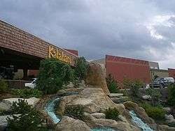
- Kalahari (Perkins Township)
- Maui Sands Waterpark & Hotel
- Rain Indoor Waterpark Located in Quality Inn & Suites
Transportation
Amtrak, the national passenger rail system, provides service to Sandusky. There are four trains daily, all arriving in the late night/early morning hours: the Capitol Limited between Chicago and Washington, D.C., via Pittsburgh; and the Lake Shore Limited between Chicago and New York/Boston via Buffalo. There is also an ongoing (as of January 2011)[29] study into the possibility of commuter rail to Cleveland.[30]
A Greyhound Lines bus station is located on Route 101 at Route 2 south of Sandusky in Margaretta Township.
Several ferry boats and routes serve Sandusky. These depart from the Jackson Street Pier, except Jet Express which departs from an adjacent pier.
- M/V Goodtime I - Seasonal daily service to Kelleys Island and South Bass Island. Also provides special party cruises and charters.
- M/V Pelee Islander - Seasonal scheduled service to Pelee Island connecting to Leamington, Ontario and Kingsville, Ontario.
- M/V Jet Express III - Provides seasonal daily service to Kelleys Island, South Bass Island, and Cedar Point which connect to Port Clinton, Ohio. It also provides excursion and cruises. Departs from former Cedar Point pier downtown.
Education
._loc_call_no_g4084s-pm007070.jpg)
Sandusky Public Schools enroll 3,775 students in public primary and secondary schools.[31] The district operates 10 public schools including six elementary schools, two middle schools, and two high schools. The city also contains one private Roman Catholic school, St. Mary Central Catholic High School.
Sandusky has one of two branches of the public Sandusky Library.[32]
Media
Sandusky (along with nearby Port Clinton and the Lake Erie Islands - known in the region collectively as "Vacationland")[33] is served by a daily newspaper, the Sandusky Register, and ten local radio stations. BAS Broadcasting (based in nearby Fremont) owns and operates WCPZ FM 102.7 (hot AC), WMJK FM 100.9 (country), WOHF FM 92.1 (classic hits), WFRO-FM FM 99.1 (AC), and WLEC AM 1450 (oldies/standards).[34]
Religious stations include WVMS FM 89.5 (run by the Moody Bible Institute as a relay of WCRF FM in Cleveland) and WGGN FM 97.7 which plays contemporary Christian music, in addition to WHRQ 88.1 FM (as a repeater of WNOC "Annunciation Radio" based in Toledo) airing programming from EWTN Global Catholic Radio.
Elyria-Lorain Broadcasting Co. operates three stations serving the "Vacationland" region, including WKFM FM 96.1 (country), WLKR-FM 95.3 (adult hits/sports) and WLKR AM 1510 (classic hits).[35]
Sandusky has two local television stations, religiously oriented WGGN-TV channel 52 (DTV 42) and the silent W41AP. Sandusky's location between Toledo and Cleveland means that the city is also served by stations (albeit at a fringe level) in both of those markets as well.
Economy
Top employers
According to Sandusky's 2012 Comprehensive Annual Financial Report,[36] the top employers in the city are:
| # | Employer | # of employees |
|---|---|---|
| 1 | Cedar Point | 5,627 |
| 2 | Firelands Regional Health System | 2,014 |
| 3 | Sandusky City School District | 810 |
| 4 | Erie County | 590 |
| 5 | Tsubaki | 377 |
| 6 | Stein Hospice | 346 |
| 7 | Kyklos Bearings International | 254 |
| 8 | Flex-N-Gate | 248 |
| 9 | City of Sandusky | 235 |
| 10 | Sandusky International, Inc. | 145 |
Perkins Township
Perkins Township is a township that lies south of Perkins Avenue, which bisects what is informally considered the Sandusky Metropolitan Area. The Sandusky Mall and the Sandusky Speedway are located south of Perkins Avenue, and therefore lie in Perkins Township. Perkins Township does not have its own main post office, so the township uses Sandusky city's ZIP code of 44870.
Notable people
- John Beatty (1828-1914) − banker, U.S. Representative (1868–73); brigadier general during Civil War
- Bill Berry - drummer for band R.E.M.; lived in Sandusky 1968-72
- Andrew Biemiller − U.S. Representative from Wisconsin
- Brian Bixler − Major League Baseball player
- Brandy Burre − actress, Theresa D'Agostino on HBO series The Wire
- Roger Carter − professional darts player
- Chris Castle − folk/Americana singer-songwriter
- Dandridge MacFarlan Cole (1921–65) − aerospace engineer, futurist, author
- Henry D. Cooke (1825–81) − financier, journalist, railroad executive, politician
- Jay Cooke (1821–1905) − Civil War financier, railroad magnate, philanthropist
- Jay Crawford − sportscaster
- Corey Croom − football player
- Thom Darden − defensive back for Cleveland Browns, 1972-1981
- Robert L. Denig - major general, Marine Corps; Sandusky's highest-ranking sea service officer
- John Emerson, born Clifton Paden (1874-1956), actor, playwright, director of silent films
- Chad Fairchild − Major League Baseball umpire
- George Feick (1849-1932) − builder of Wyoming State Capitol, buildings in and near Sandusky
- Charles Frohman (1856-1915) − producer, co-founder of Theatrical Syndicate
- Daniel Frohman (1851-1940) − theatrical producer, film producer
- Andy Gerold − guitarist with Marilyn Manson
- Jon Gruden − NFL head coach and TV analyst
- Rodney Jackson − radio personality and music producer
- Fred Kelsey (1884-1961) − actor, director
- Dick Kinzel − CEO of Cedar Fair Entertainment Company
- Aaron Kromer - NFL assistant coach
- Jeff Linkenbach − NFL offensive tackle
- William d'Alton Mann (1839-1920) − Civil War soldier, businessman, publisher
- Scott May − basketball player, NCAA national champion, 1976 Player of the Year, 1976 Olympic gold medalist; NBA player
- Jackie Mayer − Miss America 1963; section of Route 2 in Erie County is named "Jackie Mayer Miss America Highway"
- Thomas J. Moyer (1939–2010) − chief justice of Ohio Supreme Court from 1987 to 2010
- Dennis Murray − Democratic member of Ohio House of Representatives
- George Nichols − light heavyweight boxing champion
- Catherine Opie − artist, professor of photography at UCLA
- Orlando Pace − offensive lineman in Pro Football Hall of Fame; played for Sandusky High School, which retired his jersey number
- Kevin Randleman − 2-time Division I NCAA wrestling champion for The Ohio State University, mixed martial arts fighter
- Blanche Roosevelt (1853–98) − opera singer and author
- Edmund Ross − senator whose vote prevented impeachment of President Andrew Johnson
- William F. Schaub (1900–99) − U.S. Assistant Secretary of Army 1961-62
- Elmer Smith (1892-1984) − Major League Baseball outfielder 1914-25; helped Cleveland Indians win 1920 World Series
- Brad Snyder − Major League Baseball player
- Orville James Victor (1827-1910) − theologian, journalist, abolitionist
- Dave Waddington − powerlifter and strongman; first to break 1,000-pound barrier in squat
- Alvin F. Weichel (1891-1956) − Republican in U.S. House of Representatives (1943–55)
References
- ↑ "City Commission Meet Your Commissioners". City of Sandusky. Retrieved January 16, 2016.
- 1 2 "US Gazetteer files 2010". United States Census Bureau. Archived from the original on 2012-01-24. Retrieved 2013-01-06.
- 1 2 "American FactFinder". United States Census Bureau. Retrieved 2013-01-06.
- ↑ "Annual Estimates of the Resident Population for Incorporated Places: April 1, 2010 to July 1, 2014". Archived from the original on May 23, 2015. Retrieved June 4, 2015.
- 1 2 3 "American FactFinder". United States Census Bureau. Retrieved 2008-01-31.
- ↑ "US Board on Geographic Names". United States Geological Survey. 2007-10-25. Retrieved 2008-01-31.
- ↑ "Find a County". National Association of Counties. Retrieved 2011-06-07.
- ↑ "Geographic Identifiers: 2010 Demographic Profile Data (G001): Sandusky city, Ohio". U.S. Census Bureau, American Factfinder. Retrieved March 8, 2016.
- ↑ "American FactFinder". Factfinder2.census.gov. Retrieved 2017-02-27.
- 1 2 Fisher, Daniel (2011-08-10). "Best Places To Live Cheaply". Forbes.
- ↑ "Roller Coasters | Adrenaline Rush Activities | Cedar Point". www.cedarpoint.com. Retrieved 2017-09-13.
- ↑ TODAY. "Top 10 tallest roller coasters in America". TODAY.com. Retrieved 2017-09-13.
- ↑ Johnston, John (1858). Vocabularies of the Shawanoese and Wyandott Languages, etc. Wyandot.org. Retrieved 2017-02-27.
- ↑ "Wyandot Dictionary" (PDF). Retrieved 2012-05-22.
- ↑ "Carte de la Louisiane et du cours du Mississipi [i.e. Mississippi]: dressâee sur un grand nombre de mâemoires entrautres sur ceux de Mr. le Maire / par Guillaume Del'isle del Academie R'le. des Sciences". Memory.loc.gov. Retrieved 2014-03-05.
- ↑ "Composite: British Empire in America. / Popple, Henry / 1733". Davidrumsey.com. 1999-02-22. Retrieved 2014-03-05.
- 1 2 3 Lucy Elliot Keeler (1912-09-15). Old Fort Sandoski of 1745 and the 'Sandusky Country'. Ohio Archæological and Historical Quarterly. 21. Ohio State Archaeological and Historical Society. pp. 357-405). Retrieved 2018-07-31.
- ↑ Williams, William W. (1879). History of the Fire Lands, Comprising Huron and Erie Counties, Ohio. Press of Leader Printing Company. p. 431.
- ↑ "US Gazetteer files: 2010, 2000, and 1990". United States Census Bureau. 2011-02-12. Retrieved 2011-04-23.
- ↑ "Weatherbase: Historical Weather for Sandusky, Ohio". Retrieved on 2008-11-13.
- 1 2 Monthly Averages for Sandusky, OH. The Weather Channel. Retrieved on 2008-11-13.
- ↑ "Climate Summaries". Midwestern Regional Climate Center. Archived from the original on July 26, 2010. Retrieved November 27, 2012.
- ↑ Lucy Elliot Keeler (1912-09-15). Old Fort Sandoski of 1745 and the 'Sandusky Country'. Ohio Archæological and Historical Quarterly. 21. Ohio State Archaeological and Historical Society. pp. 357-368). Retrieved 2018-07-31.
- ↑ "Population and Housing Unit Estimates". Retrieved May 26, 2018.
- ↑ "Number of Inhabitants: Ohio" (PDF). 18th Census of the United States. U.S. Census Bureau. Retrieved 22 November 2013.
- ↑ "Ohio: Population and Housing Unit Counts" (PDF). U.S. Census Bureau. Retrieved 22 November 2013.
- ↑ "Incorporated Places and Minor Civil Divisions Datasets: Subcounty Population Estimates: April 1, 2010 to July 1, 2012". U.S. Census Bureau. Archived from the original on 17 June 2013. Retrieved 25 November 2013.
- 1 2 "Welcome". Sanduskybaybargeparty.com.
- ↑ "U.S. Ambassador to Haiti Kenneth Merten; passenger train from Cleveland to Sandusky: Whatever happened to ... ?". Cleveland Plain Dealer. 16 January 2011. Retrieved 5 February 2011.
- ↑ "Passenger rail service between Cleveland and Sandusky to be studied". Cleveland Plain Dealer. 2 February 2010. Retrieved 5 February 2011.
- ↑ Great Schools.com. "Sandusky City School District Profile". Retrieved 2008-07-21.
- ↑ "About us". Sandusky Library. Retrieved 25 February 2018.
- ↑ "Sandusky History: Ohio's Lake Erie Vacationland". Sanduskyhistory.blogspot.com. 2010-06-10. Retrieved 2017-02-27.
- ↑ "BAS Broadcasting - Your Ohio Radio Stations". Basohio.com. Retrieved 2017-02-27.
- ↑ "Elyria-Lorain Broadcasting Company". Elbc.northcoastnow.com. Retrieved 2017-02-27.
- ↑ "City of Sandusky CAFR" (PDF). Audits.auditor.state.oh.us. Retrieved 2014-03-05.
External links
| Wikimedia Commons has media related to Sandusky, Ohio. |
- City of Sandusky official website

- Sandusky, Ohio at Curlie (based on DMOZ)
Municipalities and communities of Erie County, Ohio, United States | ||
|---|---|---|
| Cities | 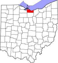 | |
| Villages | ||
| Townships | ||
| CDPs | ||
| Unincorporated communities | ||
| Footnotes | ‡This populated place also has portions in an adjacent county or counties | |