Bellevue, Ohio
| Bellevue, Ohio | |
|---|---|
| City | |
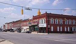 East Main Street, downtown | |
| Motto(s): "Heart Of It All" | |
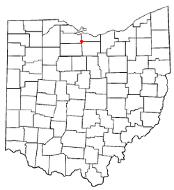 Location of Bellevue, Ohio | |
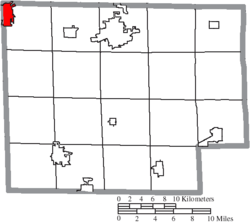 Location of Bellevue in Huron County | |
| Coordinates: 41°16′33″N 82°50′32″W / 41.27583°N 82.84222°WCoordinates: 41°16′33″N 82°50′32″W / 41.27583°N 82.84222°W | |
| Country | United States |
| State | Ohio |
| Counties | Erie, Huron, Sandusky |
| Government | |
| • Mayor | Kevin Strecker |
| Area[1] | |
| • Total | 6.26 sq mi (16.21 km2) |
| • Land | 6.14 sq mi (15.90 km2) |
| • Water | 0.12 sq mi (0.31 km2) |
| Elevation[2] | 751 ft (229 m) |
| Population (2010)[3] | |
| • Total | 8,202 |
| • Estimate (2012[4]) | 8,133 |
| • Density | 1,335.8/sq mi (515.8/km2) |
| Time zone | UTC-5 (Eastern (EST)) |
| • Summer (DST) | UTC-4 (EDT) |
| ZIP code | 44811 |
| Area code(s) | 419, 567 |
| FIPS code | 39-05228[5] |
| GNIS feature ID | 1064408[2] |
| Website | http://www.cityofbellevue.com/ |
Bellevue (/ˈbɛlvjuː/)[6] is a city in Erie, Huron and Sandusky counties[7] in the U.S. state of Ohio, located 61 miles southwest of Cleveland and 45 miles southeast of Toledo. The population was 8,202 at the 2010 census. The National Arbor Day Foundation has designated Bellevue as a Tree City USA.
The Sandusky County portion of Bellevue is part of the Fremont Micropolitan Statistical Area, while the Huron County portion is part of the Norwalk Micropolitan Statistical Area. The small portion of the city that extends into Erie county is part of the Sandusky Micropolitan Statistical Area.
Bellevue was the home of Henry Morrison Flagler when he partnered up with John D. Rockefeller to start Standard Oil. Flagler later went on to build the Florida Overseas Railroad, to Key West, Florida. The property of his former Bellevue residence on Southwest Street is the current location of the Mad River & NKP Railroad Museum.
The city derives its name from James H. Bell, a railroad official.[8]
Geography
Bellevue is located at 41°16′33″N 82°50′32″W / 41.27583°N 82.84222°W (41.275808, -82.842099).[9]
According to the 2010 census, the city has a total area of 6.25 square miles (16.2 km2), of which 6.14 square miles (15.9 km2) (or 98.24%) is land and 0.12 square miles (0.31 km2) (or 1.92%) is water.[10]
Demographics
| Historical population | |||
|---|---|---|---|
| Census | Pop. | %± | |
| 1860 | 785 | — | |
| 1870 | 1,219 | 55.3% | |
| 1880 | 2,169 | 77.9% | |
| 1890 | 3,052 | 40.7% | |
| 1900 | 4,101 | 34.4% | |
| 1910 | 5,209 | 27.0% | |
| 1920 | 5,776 | 10.9% | |
| 1930 | 6,256 | 8.3% | |
| 1940 | 6,127 | −2.1% | |
| 1950 | 7,406 | 20.9% | |
| 1960 | 8,800 | 18.8% | |
| 1970 | 10,423 | 18.4% | |
| 1980 | 9,806 | −5.9% | |
| 1990 | 9,085 | −7.4% | |
| 2000 | 8,193 | −9.8% | |
| 2010 | 8,202 | 0.1% | |
| Est. 2017 | 7,966 | [11] | −2.9% |
| Sources:[5][12][13][14][15][16][17][18] | |||
2010 census
As of the census[3] of 2010, there were 8,202 people, 3,296 households, and 2,148 families residing in the city. The population density was 1,335.8 inhabitants per square mile (515.8/km2). There were 3,662 housing units at an average density of 596.4 per square mile (230.3/km2). The racial makeup of the city was 96.3% White, 0.6% African American, 0.2% Native American, 0.2% Asian, 0.7% from other races, and 2.0% from two or more races. Hispanic or Latino of any race were 3.2% of the population.
There were 3,296 households of which 34.5% had children under the age of 18 living with them, 46.9% were married couples living together, 12.9% had a female householder with no husband present, 5.4% had a male householder with no wife present, and 34.8% were non-families. 29.8% of all households were made up of individuals and 12.5% had someone living alone who was 65 years of age or older. The average household size was 2.45 and the average family size was 3.01.
The median age in the city was 36.5 years. 26% of residents were under the age of 18; 8.5% were between the ages of 18 and 24; 26.6% were from 25 to 44; 24.3% were from 45 to 64; and 14.5% were 65 years of age or older. The gender makeup of the city was 47.9% male and 52.1% female.
2000 census
As of the census[5] of 2000, there were 8,193 people, 3,332 households, and 2,242 families residing in the city. The population density was 1,619.8 people per square mile (625.2/km²). There were 3,559 housing units at an average density of 703.6 per square mile (271.6/km²). The racial makeup of the city was 97.77% White, 0.27% African American, 0.15% Native American, 0.27% Asian, 0.82% from other races, and 0.73% from two or more races. Hispanic or Latino of any race were 2.56% of the population.
There were 3,332 households out of which 32.8% had children under the age of 18 living with them, 53.2% were married couples living together, 10.4% had a female householder with no husband present, and 32.7% were non-families. 27.6% of all households were made up of individuals and 12.4% had someone living alone who was 65 years of age or older. The average household size was 2.46 and the average family size was 3.01.
In the city the population was spread out with 26.5% under the age of 18, 8.3% from 18 to 24, 29.1% from 25 to 44, 21.5% from 45 to 64, and 14.6% who were 65 years of age or older. The median age was 36 years. For every 100 females, there were 93.1 males. For every 100 females age 18 and over, there were 88.6 males.
The median income for a household in the city was $88,100, and the median income for a family was $98,173. Males had a median income of $76,601 versus $44,189 for females. The per capita income for the city was $58,932. About 1.3% of families and 2.8% of the population were below the poverty line, including 1.5% of those under age 18 and 1% of those age 65 or over.
Public safety
Bellevue is served by full-time police, fire, and EMS agencies. The Bellevue Police Department is responsible for providing law enforcement services. The department's dispatch center handles 911 calls from the community. Bellevue police maintains road patrol officers 24 hours a day, 365 days a year. The department also has a detective division, and since 2012, a K9 unit.
The Bellevue Fire Department serves Bellevue and three surrounding townships, Lyme (Huron County), Thompson (Seneca County), and York (Sandusky County). The department maintains both full-time and paid on-call fire fighters. It has eight vehicles, including a 95-foot ladder truck, a grass fighter, three engines, two tankers, and a chief's command vehicle.
Bellevue contracts with North Central EMS to provide emergency medical services to city residents. The North Central station in Bellevue is staffed with nationally registered EMTs and paramedics. It typically operates two advanced life support ambulances.
Education
Local high school students can attend Bellevue High School or EHOVE Career Center; there is also the option of open enrollment in neighboring public school districts. Furthermore, Catholic elementary and junior high, Immaculate Conception School (and church; Immaculate Conception Church) is available as a private school option. They recently built new elementary school, combining all the smaller schools into one, and a middle school. Due to the city's location, other high school education is available nearby at Tiffin Calvert High School in Tiffin, St. Joseph Central Catholic High School in Fremont, St. Mary Central Catholic High School in Sandusky, or St. Paul High School in Norwalk.
Media
Bellevue and the surrounding area are served by a bi-weekly newspaper, The Bellevue Gazette. The Gazette recently closed in June 2016, and is no longer in operation.
Transportation
Roads
Bellevue is located on U.S. Route 20, which forms East and West Main Street. State Routes 18, 269, and 113 also run through the city. There is no public transportation, such as passenger buses or taxis. Bellevue is also served by the Ohio Turnpike via U.S. Route 20 and State Route 4.
Railroad
During the first half of the 20th century, Bellevue was a busy railroad hub of the Nickel Plate Road, and it remains today as a hub for the Norfolk Southern Railway, which operates a massive railroad yard in Bellevue. From Bellevue, Norfolk Southern Lines extend northeast to Cleveland, north to Sandusky, northwest to Toledo, west to Fort Wayne, Indiana and south to Columbus. Also, the Wheeling and Lake Erie Railway operates a line from Bellevue that extends east to Pittsburgh, Pennsylvania.
Notable people
- Brittany Binger - June 2007 Playboy Playmate
- Henry Flagler - Standard Oil tycoon, developer of Eastern Florida and "Father of Miami", began his business career in Bellevue in the 1840s
- Mildred Gillars - radio personality during World War II, best known for propaganda broadcasts for Nazi Germany; also known as Axis Sally [19][20]
- Arthur F. Gorham - Commander of the 1st Battalion, 505th Parachute Infantry Regiment during World War II; twice awarded the Distinguished Service Cross the nation's second highest award for bravery
- John Greenslade - Vice Admiral and U.S. Commander of the Pacific-Southern Naval Coastal Frontier during World War II
- Daniel M. Harkness - half brother of Henry Flagler and his son William L. Harkness, investors in Standard Oil
- Stephen V. Harkness - who invested as a silent partner with Henry Morrison Flagler and oil titan John D. Rockefeller, Sr. in the founding of Standard Oil. Stephen's son Lamon V. Harkness was born in Bellevue and went on to become extremely wealthy from the Harkness investments in Standard Oil
- Benny LaPresta - NFL professional football player
- Amos Northup - automotive designer[21][22]
- Christi Paul - CNN reporter and anchor
- Bradbury Robinson - threw the first forward pass in American football history
- Brad Snyder - 2003 Mid-American Conference Baseball Player of the Year, a NCAA Division I All-American, and outfielder for Chicago Cubs.
- Howard L. Vickery - Rear Admiral, Vice Chairman U.S. Maritime Commission during World War II
National Register of Historic Places
Bellevue and the surrounding countryside are home to three sites listed on the National Register of Historic Places: the Heter Farm, the John Wright Mansion, and the Tremont House.[23]
Bibliography
- Camp, Mark J. "Railroad Depots of Northwest Ohio." Chicago, Arcadia Publishing, 2005. ISBN 978-0-7385-3401-5.
- Drown, William. "Bellevue and Historic Lyme Village (OH)." Chicago: Arcadia Publishing, 2002. ISBN 978-0-7385-2023-0.
- Oddo, William. "Bellevue, a Pictorial History: A Historic Reflection of an Ohio Community." Genealogy Publishing Services, 2005. ISBN 978-1-881851-21-9.
References
- ↑ "US Gazetteer files 2010". United States Census Bureau. Archived from the original on 2012-01-24. Retrieved 2013-01-06.
- 1 2 "US Board on Geographic Names". United States Geological Survey. 2007-10-25. Archived from the original on 2012-02-26. Retrieved 2008-01-31.
- 1 2 "American FactFinder". United States Census Bureau. Archived from the original on 2012-02-17. Retrieved 2013-01-06.
- ↑ "Population Estimates". United States Census Bureau. Archived from the original on 2013-06-17. Retrieved 2013-06-17.
- 1 2 3 "American FactFinder". United States Census Bureau. Archived from the original on 2013-09-11. Retrieved 2008-01-31.
- ↑ "A Pronunciation Guide to places in Ohio -- E.W.Scripps School of". scrippsjschool.org. Archived from the original on 24 April 2018. Retrieved 24 April 2018.
- ↑ "Voter Registration Information". City of Bellevue. Archived from the original on 2013-12-27. Retrieved 2013-12-27.
- ↑ Overman, William Daniel (1958). Ohio Town Names. Akron, OH: Atlantic Press. p. 11.
- ↑ "US Gazetteer files: 2010, 2000, and 1990". United States Census Bureau. 2011-02-12. Archived from the original on 2012-03-12. Retrieved 2011-04-23.
- ↑ "2010 Census U.S. Gazetteer Files for Places – Ohio". United States Census. Archived from the original on 2016-07-02. Retrieved 2012-10-19.
- ↑ "Population and Housing Unit Estimates". Archived from the original on May 29, 2017. Retrieved June 9, 2017.
- ↑ "Population of Civil Divisions Less than Counties" (PDF). Statistics of the Population of the United States at the Tenth Census. U.S. Census Bureau. Retrieved 28 November 2013.
- ↑ "Population of Civil Divisions Less than Counties" (PDF). Statistics of the Population of the United States at the Tenth Census. U.S. Census Bureau. Archived (PDF) from the original on 29 June 2014. Retrieved 28 November 2013.
- ↑ "Population: Ohio" (PDF). 1910 U.S. Census. U.S. Census Bureau. Archived (PDF) from the original on 10 November 2013. Retrieved 28 November 2013.
- ↑ "Population: Ohio" (PDF). 1930 US Census. U.S. Census Bureau. Archived (PDF) from the original on 9 June 2011. Retrieved 28 November 2013.
- ↑ "Number of Inhabitants: Ohio" (PDF). 18th Census of the United States. U.S. Census Bureau. Retrieved 22 November 2013.
- ↑ "Ohio: Population and Housing Unit Counts" (PDF). U.S. Census Bureau. Archived (PDF) from the original on 9 January 2014. Retrieved 22 November 2013.
- ↑ "Incorporated Places and Minor Civil Divisions Datasets: Subcounty Population Estimates: April 1, 2010 to July 1, 2012". U.S. Census Bureau. Archived from the original on 17 June 2013. Retrieved 25 November 2013.
- ↑ C. "Conneaut City Schools Memo to the U.S. Department of Justice" (PDF). Archived (PDF) from the original on 2010-06-05. Retrieved 2010-05-26.
- ↑ Drown, p. 62
- ↑ Coachbuilt. "Amos E. Northup, 1889-1937". Archived from the original on 2008-10-14. Retrieved 2009-05-13.
- ↑ The Industrial Designers Society of America. "Amos Northup". Retrieved 2009-05-13.
- ↑ National Park Service (2010-07-09). "National Register Information System". National Register of Historic Places. National Park Service.
External links
| Wikimedia Commons has media related to Bellevue, Ohio. |
Municipalities and communities of Erie County, Ohio, United States | ||
|---|---|---|
| Cities |  | |
| Villages | ||
| Townships | ||
| CDPs | ||
| Unincorporated communities | ||
| Footnotes | ‡This populated place also has portions in an adjacent county or counties | |
Municipalities and communities of Huron County, Ohio, United States | ||
|---|---|---|
| Cities | 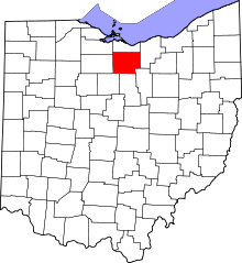 | |
| Villages | ||
| Townships | ||
| CDPs | ||
| Unincorporated communities | ||
| Footnotes | ‡This populated place also has portions in an adjacent county or counties | |
Municipalities and communities of Sandusky County, Ohio, United States | ||
|---|---|---|
| Cities | 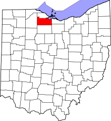 | |
| Villages | ||
| Townships | ||
| CDPs | ||
| Unincorporated communities | ||
| Footnotes | ‡This populated place also has portions in an adjacent county or counties | |