Whites Landing, Ohio
| Whites Landing, Ohio | |
|---|---|
| Census-designated place | |
 Whites Landing | |
| Coordinates: 41°25′47″N 82°54′3″W / 41.42972°N 82.90083°WCoordinates: 41°25′47″N 82°54′3″W / 41.42972°N 82.90083°W | |
| Country | United States |
| State | Ohio |
| Counties | Erie, Sandusky |
| Townships | Margaretta, Townsend |
| Area[1] | |
| • Total | 0.29 sq mi (0.76 km2) |
| • Land | 0.29 sq mi (0.76 km2) |
| • Water | 0 sq mi (0 km2) |
| Elevation[2] | 580 ft (180 m) |
| Population (2010)[1] | |
| • Total | 375 |
| • Density | 1,280/sq mi (494.2/km2) |
| Time zone | UTC-5 (Eastern (EST)) |
| • Summer (DST) | UTC-4 (EDT) |
| Area code(s) | 419 / 567 |
| FIPS code | 39-84882[1] |
| GNIS feature ID | 1049326[2] |
Whites Landing is an unincorporated community and census-designated place in Erie and Sandusky counties, Ohio, United States. As of the 2010 census it had a population of 375.[1] It is located within Margaretta and Townsend townships.
Geography
Whites Landing is located on the border between Erie and Sandusky counties, on the south shore of Sandusky Bay, an arm of Lake Erie. It is 11 miles (18 km) west of the city of Sandusky and 14 miles (23 km) northeast of Fremont.
References
- 1 2 3 4 "Geographic Identifiers: 2010 Demographic Profile Data (G001): Whites Landing CDP, Ohio". U.S. Census Bureau, American Factfinder. Retrieved March 10, 2016.
- 1 2 U.S. Geological Survey Geographic Names Information System: Whites Landing, Ohio
Municipalities and communities of Erie County, Ohio, United States | ||
|---|---|---|
| Cities | 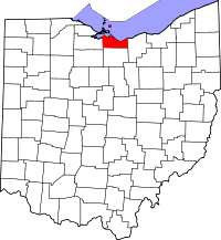 | |
| Villages | ||
| Townships | ||
| CDPs | ||
| Unincorporated communities | ||
| Footnotes | ‡This populated place also has portions in an adjacent county or counties | |
This article is issued from
Wikipedia.
The text is licensed under Creative Commons - Attribution - Sharealike.
Additional terms may apply for the media files.