North Bass Island

North Bass Island is an island of the U.S. state of Ohio located in Lake Erie.[1] A small unincorporated community, Isle Saint George, is on the island.[2] The North Bass Island Post Office was established on May 25, 1864, and the name changed to Isle Saint George Post Office on March 2, 1874.[3] The Isle Saint George ZIP code 43436 provides PO Box service.[4]
The 688.6-acre (2.786 km²) island is one of few islands that has not been commercially developed. The state of Ohio purchased 589 acres (2.4 km²) of the island to preserve it from development and operates it as North Bass Island State Park.
Historically, North Bass was mainly used as a vineyard. According to the 2000 census the island had 13 permanent residents.[5] The island's only public school closed in 2006 after more than a century of operation.[6] As of January 2007, there were roughly two dozen permanent residents residing on the island's 12 privately owned properties.[7]
North Bass Island Airport (FAA LID: 3X5) offers a 1,804 ft (549.9 m) paved airstrip.[8]
Geography
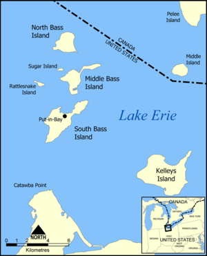
North Bass Island is the second largest and northernmost island of the Bass Islands; which are a part of the larger Lake Erie Islands archipelago. On the southwest corner of the island there is a small bay named Manila Bay and there is a small unnamed creek that protrudes from the bay. The island is part of Put-in-Bay Township, Ottawa County, Ohio.
See also
References
- ↑ U.S. Geological Survey Geographic Names Information System: North Bass Island
- ↑ U.S. Geological Survey Geographic Names Information System: Isle Saint George
- ↑ U.S. Geological Survey Geographic Names Information System: Isle Saint George Post Office
- ↑ ZIP Code Lookup, United States Postal Service
- ↑ North Bass Island: Blocks 1075 thru 1082, Census Tract 501, Ottawa County, Ohio United States Census Bureau
- ↑ Zelm, Annie (November 30, 2011). "Ohio island school considers ideas to stay afloat as enrollment dwindles". Sandusky Register. Sandusky Newspapers. Retrieved October 3, 2016.
- ↑ http://www.dnr.state.oh.us/tabid/18406/default.aspx, Ohio Department of Natural Resources
- ↑ "North Bass Island". FAA. Retrieved 3 April 2013.
External links
- North Bass Island State Park - official site
Coordinates: 41°43′00″N 82°49′00″W / 41.71667°N 82.81667°W