San Miguel (volcano)
| San Miguel | |
|---|---|
| Volcán Chaparrastique | |
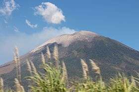 Volcano in 2013 | |
| Highest point | |
| Elevation | 2,130 m (6,990 ft) |
| Coordinates | 13°25′54″N 88°16′17″W / 13.43167°N 88.27139°WCoordinates: 13°25′54″N 88°16′17″W / 13.43167°N 88.27139°W |
| Geography | |
| Location | San Miguel Department, El Salvador |
| Geology | |
| Mountain type | Stratovolcano |
| Last eruption | January 2016[1] |
San Miguel (also known as Volcán Chaparrastique) is a stratovolcano in central-eastern El Salvador, approximately 15 km southwest of the city of San Miguel. On January 16, 2002, a minor eruption of steam, gas, and ash occurred from the summit crater,[2] lasting 3 hours but causing no real damage to life or property. Carbon dioxide emissions had been monitored since November 2001, and their steady increase continued to build up until the eruption.[2]
Eleven years later,[3] on December 29, 2013, San Miguel erupted at 10:30 local time spewing ash and smoke into the sky, and prompted the evacuation of thousands of people living in a 3 km radius around the volcano.[4] It was preceded and caused by increased seismic activity beginning at 06:30 local time.[4]
See also
Gallery

 The eruption column on December 29, 2013/
References
- ↑ Voiland, Adam. "Eruption of San Miguel, El Salvador". NASA Earth Observatory. Retrieved 14 January 2016.
- 1 2 Perez, Nemesio (April 2006). "Anomalous Diffuse CO2 Emission Prior to the January 2002 Short-Term Unrest at San Miguel Volcano". Pure and Applied Geophysics. doi:10.1007/s00024-006-0050-1.
- ↑ Tadeo, Maria (30 December 2013). "El Salvador begins evacuation after Chaparrastique volcano erupts for the first time in 37 years". The Independent. Retrieved 30 December 2013.
- 1 2 San Miguel volcano (El Salvador): new eruption. Volcano Discovery. Retrieved 30 December 2013.
External links

- Global Volcanism Program
| Guatemala | 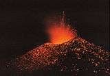 | |
|---|---|---|
| El Salvador | ||
| Nicaragua | ||
| Costa Rica | ||
| Panama | ||
Note: volcanoes are ordered from north-west to south-east. | ||
]