Acatenango
| Acatenango | |
|---|---|
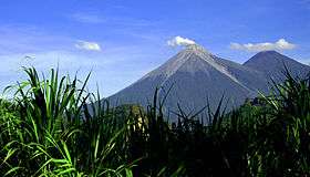 Volcán de Fuego (left) and Acatenango (right) | |
| Highest point | |
| Elevation | 3,976 m (13,045 ft) |
| Prominence | 1,835 m (6,020 ft) [1] |
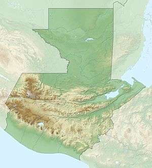
| Coordinates | 14°30′03″N 90°52′33″W / 14.50083°N 90.87583°WCoordinates: 14°30′03″N 90°52′33″W / 14.50083°N 90.87583°W |
| Geography | |
 Acatenango | |
| Parent range | Sierra Madre |
| Geology | |
| Age of rock | 200 Kyr |
| Mountain type | Stratovolcano |
| Volcanic arc | Central America Volcanic Arc |
| Last eruption | November to December 1972 |
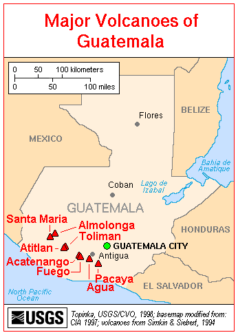
Acatenango is a stratovolcano in Guatemala, close to the city of Antigua. The volcano has two peaks, Pico Mayor (Highest Peak) and Yepocapa (3,880 m) which is also known as Tres Hermanas (Three Sisters). Acatenango is joined with Volcán de Fuego and collectively the volcano complex is known as La Horqueta.
Description
The Fuego-Acatenango massif comprises a string of five or more volcanic vents along a north-south trend that is perpendicular to that of the Central American Volcanic Arc in Guatemala. From north to south, known centres of volcanism are Ancient Acatenango, Yepocapa, Pico Mayor de Acatenango, Meseta, and Fuego. Volcanism along the trend stretches back more than 200,000 years. Although many of the centres have been active contemporaneously, there is a general sequence of younger volcanism, from north to south along the trend.[2]
This massive volcano complex towers more than 3,500 metres above the Pacific coastal plain to the south and 2,000 metres above the Guatemalan Highlands to the north. The volcano complex comprises remnants of multiple eruptive centres, which periodically have collapsed to form huge debris avalanches. The largest of these avalanches extended more than 50 kilometres from its source and covered more than 300 square kilometres.[2]
Eruption history
The only known historical eruptions of Acatenango volcano occurred in the 20th century, between 1924 and 1927 from just north of the summit peak (Pico Mayor) and again in December 1972 from the saddle between Yepocapa and Pico Mayor. These phreatic explosions generated ballistic volcanic bombs that fell near the summit craters and fine volcanic ash that fell up to 25 km away.
In prehistoric time, Acatenango has erupted explosively to form widespread fall deposits, hot pyroclastic flows and lava flows. There have been numerous eruptions during the past 80,000 years from vents along the massif. The most recent explosive eruptions of Acatenango occurred 1,900 years ago (Pico Mayor), 2,300 years ago (Pico Mayor) and about 5,000 years ago (Yepocapa). If such eruptions were to recur, many people and costly infrastructure would be at risk.
Volcanic hazards
The volcano has potential to produce huge debris avalanches that could inundate large areas of the Pacific coastal plain. In areas around the volcanoes and downslope toward the coastal plain, more than 100,000 people are potentially at risk from these and other flowage phenomena.
Hiking the Volcano
For visitors to Antigua in Guatemala; Acatenango Volcano and the neighbouring Volcan de Fuego (Fire Volcano) can be an irresistible adventure.[3] While it would be unsafe and irresponsible to hike the active Volcan de Fuego, it is possible to hike to the summit of Acatenango and watch Fuego erupt from a safe distance. It is a tough hike up steep slopes with loose volcanic rocks and the altitude can be a challenge for some. There are different options, 1 day or 2 days tours available from Antigua. To get the most from the hike, it is best to spend the night on the volcano, so that it is possible to see Fuego erupt at night, when it is most impressive. Make sure you research the tour company you are doing your trek with well – six tourists died of exposure on Acatenango in January 2017[4]
Economy
The Acatenango Valley is a designated coffee-producing region of Anacafé.
Gallery
| Wikimedia Commons has media related to Acatenango. |
 Volcan de Acatenango, seen at night from Volcan de Fuego.
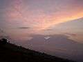 Sunset behind Acantenago and Fuego, seen from the lower north side of Volcan de Agua.
See also
References
- ↑ "Volcán Acatenango, Guatemala". Peakbagger.com.
- 1 2 Vallance, J.W.; Schilling, S.P.; Matías, O.; Rose, W.I.; Howell, M.M (2001). "Volcano Hazards at Fuego and Acatenango, Guatemala". USGS Open-File Report 01-431. USGS.
- ↑ http://adventureofalifetime.co.uk/acatenango-volcano-hike-fuego/ Hiking Acatenango Article
- ↑ https://www.gov.uk/foreign-travel-advice/guatemala
External links

- Excerpts from: Vallance, et al., 2001, Volcano Hazards at Fuego and Acatenango, Guatemala: USGS Open-File Report 01-431
- "Acatenango". Global Volcanism Program. Smithsonian Institution.
| Guatemala | 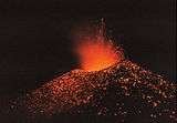 | |
|---|---|---|
| El Salvador | ||
| Nicaragua | ||
| Costa Rica | ||
| Panama | ||
Note: volcanoes are ordered from north-west to south-east. | ||