Laguna Poco Sol
Coordinates: 10°21′N 84°40′W / 10.35°N 84.67°W[1] Laguna Poco Sol is a volcanic lake in Costa Rica, in the Cordillera de Tilarán.[2]
The lake lies at an altitude of 789 metres (2,589 ft). It lies in a 200 metres (660 ft) wide depression.[1] The depth of the lake is about 11.5 metres (38 ft).[3]
Other volcanic features in the area include breccia, lahar deposits, lava flows and tuffs. The lake may be a landslide scar, or a crater left by a phreatic explosion. It is of probable Pleistocene age.[1][4] It is constructed within the andesitic Monteverde Formation,[4] which was erupted between 2.1 and 1 million years ago.[3]
Hot springs, mud pots and deposits of sulfur are found both at the lake and near the Río Penas Blancas.[1] The area has been investigated for the possibility of obtaining geothermal energy from it. The geothermal activity may be the source of the name Pocosol.[3]
The active volcano Arenal lies north-northwest of Laguna Poco Sol.[4] Arenal along with Cerro Chato between Arenal and Laguna Poco Sol and Cerro Pocosol south of Laguna Poco Sol may be located along a zone of tectonic weakness that was accompanied by northeast-migrating volcanism.[3]
References
- 1 2 3 4 "Laguna Poco Sol". Global Volcanism Program. Smithsonian Institution.
- ↑ Nadkarni, Nalini M.; Wheelwright, Nathaniel T. (2000-03-09). Monteverde: Ecology and Conservation of a Tropical Cloud Forest. Oxford University Press. ISBN 9780199770977.
- 1 2 3 4 Alvarado, Guillermo E. (2008-02-12). "Geología de la Hoja Fortuna, Alajuela, Costa Rica". Revista Geológica de América Central (in Spanish). 0 (41). ISSN 2215-261X.
- 1 2 3 Alvarado, Guillermo E. (2009-01-01). "Mapa geológico de la hoja Fortuna". Revista Geológica de América Central (in Spanish). Retrieved 2016-12-16.
| Guatemala | 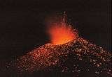 | |
|---|---|---|
| El Salvador | ||
| Nicaragua | ||
| Costa Rica | ||
| Panama | ||
Note: volcanoes are ordered from north-west to south-east. | ||