Turrialba Volcano
| Turrialba Volcano | |
|---|---|
.jpg) Turrialba Volcano in eruption, October 2014 | |
| Highest point | |
| Elevation | 3,340 metres (10,958 ft) |
| Geography | |
| Location | Cartago, Costa Rica |
| Parent range | Cordillera Central |
| Geology | |
| Age of rock | 1.5 Million Years |
| Mountain type | Stratovolcano |
| Last eruption | 2010 to 2018 (ongoing)[1] |
| Climbing | |
| Easiest route | hike |
Turrialba Volcano is an active volcano in central Costa Rica that has been explosively eruptive in recent years including 2016 [2] and in January, March and April 2017. [3][4][5][6] Visitors used to be able to hike down into the main crater, but increased volcanic activity in 2014-17, resulting in large clouds of volcanic ash, has caused the surrounding Turrialba Volcano National Park to close.
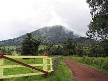
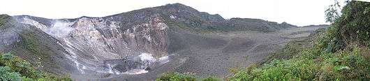
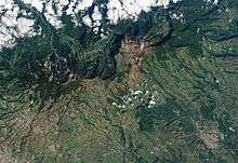
The stratovolcano is 3,340 m (10,958 ft) high and is about 45 minutes from the Atlantic slope town of Turrialba. The summit has three craters, the largest of which has a diameter of 50 m (160 ft).[7] Below the summit is a mountain range and montane forest, with ferns, bromeliads, lichens and mosses. Most of the forest is either primary or secondary forest.[8]
Turrialba is adjacent to Irazú and both are among Costa Rica's largest volcanoes. Turrialba has had at least five large explosive eruptions in last 3500 years. On clear days both the Pacific Ocean and Caribbean Sea can be seen from the summit.
The volcano is named after its canton, Turrialba, in Costa Rica's Cartago Province. There is no clear consensus on the origin of the name Turrialba, but historians disagree with attempts to attribute the name to the patronym Torrealba (from Aragon in Spain) or from the Latin Turris alba (white tower). The general consensus is that Turrialba derives from the local Indian (Huetar language), but there is no agreement on its actual roots.
This volcano is monitored by the Deep Earth Carbon Degassing Project.[9]
Activity
- During the 19th century, the volcano erupted and emitted ash several times (1847, 1853, 1855, 1859, 1866), producing pyroclastic flows. The last major eruption was in 1866.[10]
- Small signs of activity start in 1996.
- In January 2001, the volcano reported increased activity, displaying strong fumarole activity at the central craters. The volcanic activities have increased since 2005.
- On March 31, 2017, the volcano started to show some activity with ash eruptions.[11]
- The National Park area opened for visitors was closed from 2009 to 2011.
- On January 8, 2010, a phreatic eruption occurred, creating a new opening near the crater on the southwest, and the temperature increased from 200 to 600 °C (392 to 1,112 °F). Two villages, La Central and El Retiro, were evacuated.[12]
- On January, 2012 a new opening on the west of the crater was created after a phreatic eruption.
- On April 12, 2012, a small eruption occurred.[13]
- On May 21, 2013, at 08:52, a gas explosion widened several openings near the main crater that appeared in 2010 and 2012.[14]
- In July 2013 researchers found that tremors around the area increased from about twenty earthquakes a day, to up to thirty per hour.[15]
- On October 17, 2014, the quantity of tremors increased from around 50-100 a day, to 200 a day.[16]
- On October 29, 2014, at around 10:10, a tremor started and kept constant, until a phreatic eruption occurred around 23:10 at the west opening that appeared in January 2012. This eruption sent a large amount of volcanic material to areas up to 40 km (25 mi) away. Many citizens reported ash falling on their properties and a strong odor of sulphur in the cantons of Vásquez de Coronado, Goicoechea, Moravia, Desamparados, Aserrí, Escazú, Santa Ana, Montes de Oca, Tibás, Alajuelita, Puriscal, San José in the province of San José, La Union in the province of Cartago and Santo Domingo and Heredia, in the province of Heredia.[17]
March 2015
- On March 12, 2015, eruptions at around 11:00 and 14:12 sent ashes through all the Central Valley, it is regarded as the most significant activity since 1996.[18] The Juan Suantamaría and Tobías Bolaños international airports were closed due to visibility being less than 100 meters.[19]
- On March 13, 2015 an eruption occurred at 21:07.
May 2015
- On May 4, 2015 an eruption occurred at 15:24[20]
May 2016
An eruption occurred on May 21, 2016. It was characterized by one resident as the largest since 2010. Ash fell as far away as the capital, San Jose, and at least 500 people went to hospitals complaining of breathing problems. Flights into San Jose were cancelled due to concerns about ash.[21]
September 2016
On September 19, at 02:54 an eruption lasting around fifteen minutes was the first event of many through the day that eventually covered the metropolitan area with ash. There were events at 11:30, 14:40, 15:34.
The events continued through September 20 with an eruption at 06:20.
Airports in the metropolitan area were closed.[22]
See also
References
- ↑ "Turrialba volcano". 19 Feb 2018.
- ↑ "UPDATE: Eruption of Turrialba Volcano closes airport, launches ash, rocks 4 km high".
- ↑ "Ashes from Turrialba Volcano's explosions reach San José, Heredia".
- ↑ "UPDATE: Green alert declared as Turrialba Volcano ashfall intensifies".
- ↑ "Costa Rica's Turrialba Volcano resumes vapor, ash explosions".
- ↑ "Turrialba Volcano Near Cartago, Costa Rica Back in Action After Calm Spell - Costa Rica Star News". 3 April 2017.
- ↑ Stater, Adam. "The Turrialba Volcano's Craters".
- ↑ Stater, Adam. "Forest Types, Turrialba Volcano".
- ↑ "DECADE Installations at Turrialba and Poás". Deep Carbon Observatory. Retrieved 26 September 2016.
- ↑ "El Turrialba ha hecho erupción seis veces en últimos 3.500 años".
- ↑ "Actividad sísmica aumenta en el volcán Turrialba".
- ↑ "Erupciones abren dos nuevos cráteres en volcán Turrialba".
- ↑ "Volcán Turrialba hizo pequeña erupción".
- ↑ "Erupción de ceniza en volcán Turrialba ensanchó boquetes".
- ↑ "Volcán Turrialba pasó de 20 sismos por día a 30 por hora".
- ↑ "Ceniza del Turrialba alcanza a un millón de habitantes".
- ↑ "Volcán Turrialba hace erupción y provoca intensa caída de ceniza en los alrededores" [Turrialba Volcano erupts and a lot of ash fell in the surrounding areas] (in Spanish).
- ↑ "Volcán Turrialba registra la erupción más importante desde 1996" [Most important eruption since 1996 registered at Turrialba Volcano.] (in Spanish).
- ↑ "Cierran Aeropuerto Juan Santamaría debido a caída de ceniza" [Juan Santamaria airport closed due to falling ashes.] (in Spanish).
- ↑ "Costa Rica's Turrialba Volcano erupts, forcing capital airport to temporarily close".
- ↑ "Volcano ash covers Costa Rica towns". BBC. London. Retrieved 2016-05-21.
- ↑ "Eruption of Turrialba Volcano closes airport launches ash, rocks 4 km high". Tico Times. Costa Rica. Retrieved 2016-09-20.
External links
![]()