Brentonico
| Brentonico | |
|---|---|
| Comune | |
| Comune di Brentonico | |
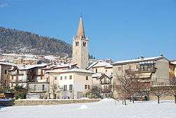 Brentonico under the snow | |
 Brentonico Location of Brentonico in Italy | |
| Coordinates: 45°49′N 10°57′E / 45.817°N 10.950°ECoordinates: 45°49′N 10°57′E / 45.817°N 10.950°E | |
| Country | Italy |
| Region | Trentino-Alto Adige/Südtirol |
| Province | Trentino (TN) |
| Frazioni | Saccone, Fontechel, Crosano, Cazzano, Castione, Corné, Prada, Sorne, S.Giacomo, S.Valentino, Polsa |
| Area | |
| • Total | 62.6 km2 (24.2 sq mi) |
| Elevation | 698 m (2,290 ft) |
| Population (Dec. 2004) | |
| • Total | 3,770 |
| • Density | 60/km2 (160/sq mi) |
| Demonym(s) | Brentegani |
| Time zone | UTC+1 (CET) |
| • Summer (DST) | UTC+2 (CEST) |
| Postal code | 38060 |
| Dialing code | 0464 |
| Patron saint | Saint Peter and Saint Paul |
| Saint day | 29 June |
| Website | Official website |
Brentonico (German: Frenten) is a comune (municipality) in Trentino in the northern Italian region Trentino-Alto Adige, located about 30 kilometres (19 mi) southwest of Trento. As of 31 December 2004, it had a population of 3,770 and an area of 62.6 square kilometres (24.2 sq mi).[1]
The municipality of Brentonico contains the frazioni (subdivisions, mainly villages and hamlets) Saccone, Fontechel, Crosano, Cazzano, Castione, Corné, Prada, Sorne, S.Giacomo, S.Valentino, and Polsa.
Brentonico borders the following municipalities: Mori, Nago-Torbole, Malcesine, Ala, and Avio.
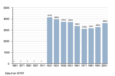
Demographic evolution
References
External links
- (in Italian) Homepage of the city

This article is issued from
Wikipedia.
The text is licensed under Creative Commons - Attribution - Sharealike.
Additional terms may apply for the media files.