Saint-Sulpice, Savoie
| Saint-Sulpice | ||
|---|---|---|
| Commune | ||
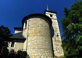 The church in Saint-Sulpice | ||
| ||
 Saint-Sulpice Location within Auvergne-Rhône-Alpes region  Saint-Sulpice | ||
| Coordinates: 45°34′07″N 5°50′45″E / 45.5686°N 5.8458°ECoordinates: 45°34′07″N 5°50′45″E / 45.5686°N 5.8458°E | ||
| Country | France | |
| Region | Auvergne-Rhône-Alpes | |
| Department | Savoie | |
| Arrondissement | Chambéry | |
| Canton | Le Pont-de-Beauvoisin | |
| Government | ||
| • Mayor (2014–2020) | Louis Caille | |
| Area1 | 8.82 km2 (3.41 sq mi) | |
| Population (2014)2 | 789 | |
| • Density | 89/km2 (230/sq mi) | |
| • Urban | 125,974 | |
| Time zone | UTC+1 (CET) | |
| • Summer (DST) | UTC+2 (CEST) | |
| INSEE/Postal code | 73281 /73160 | |
| Elevation | 352–1,041 m (1,155–3,415 ft) | |
|
1 French Land Register data, which excludes lakes, ponds, glaciers > 1 km2 (0.386 sq mi or 247 acres) and river estuaries. 2 Population without double counting: residents of multiple communes (e.g., students and military personnel) only counted once. | ||

Saint-Sulpice is a commune in the Savoie department in the Auvergne-Rhône-Alpes region in south-eastern France.
See also
References
| Wikimedia Commons has media related to Saint-Sulpice, Savoie. |
This article is issued from
Wikipedia.
The text is licensed under Creative Commons - Attribution - Sharealike.
Additional terms may apply for the media files.