Flumet
| Flumet | ||
|---|---|---|
| Commune | ||
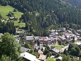 Flumet seen from the Forêt de Bisanne | ||
| ||
 Flumet Location within Auvergne-Rhône-Alpes region  Flumet | ||
| Coordinates: 45°49′13″N 6°31′03″E / 45.8203°N 6.5175°ECoordinates: 45°49′13″N 6°31′03″E / 45.8203°N 6.5175°E | ||
| Country | France | |
| Region | Auvergne-Rhône-Alpes | |
| Department | Savoie | |
| Arrondissement | Albertville | |
| Canton | Ugine | |
| Government | ||
| • Mayor (2014–2020) | Marie-Pierre Ouvrier | |
| Area1 | 17.15 km2 (6.62 sq mi) | |
| Population (2014)2 | 810 | |
| • Density | 47/km2 (120/sq mi) | |
| Time zone | UTC+1 (CET) | |
| • Summer (DST) | UTC+2 (CEST) | |
| INSEE/Postal code | 73114 /73590 | |
| Elevation | 854–1,930 m (2,802–6,332 ft) | |
|
1 French Land Register data, which excludes lakes, ponds, glaciers > 1 km2 (0.386 sq mi or 247 acres) and river estuaries. 2 Population without double counting: residents of multiple communes (e.g., students and military personnel) only counted once. | ||
.svg.png)
Flumet is a commune in the Savoie department in the Auvergne-Rhône-Alpes region in south-eastern France.
See also
| Wikimedia Commons has media related to Flumet. |
References
| Authority control |
|---|
This article is issued from
Wikipedia.
The text is licensed under Creative Commons - Attribution - Sharealike.
Additional terms may apply for the media files.