Le Pontet, Savoie
| Le Pontet | |
|---|---|
| Commune | |
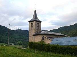 The church of Saint-Nicolas, in Le Pontet | |
 Le Pontet Location within Auvergne-Rhône-Alpes region  Le Pontet | |
| Coordinates: 45°29′56″N 6°13′48″E / 45.4989°N 6.23°ECoordinates: 45°29′56″N 6°13′48″E / 45.4989°N 6.23°E | |
| Country | France |
| Region | Auvergne-Rhône-Alpes |
| Department | Savoie |
| Arrondissement | Chambéry |
| Canton | Montmélian |
| Intercommunality | la Rochette–Val Gelon |
| Government | |
| • Mayor (2014–2020) | Eugène Montay |
| Area1 | 8.66 km2 (3.34 sq mi) |
| Population (2014)2 | 137 |
| • Density | 16/km2 (41/sq mi) |
| Time zone | UTC+1 (CET) |
| • Summer (DST) | UTC+2 (CEST) |
| INSEE/Postal code | 73205 /73110 |
| Elevation | 833–1,569 m (2,733–5,148 ft) |
|
1 French Land Register data, which excludes lakes, ponds, glaciers > 1 km2 (0.386 sq mi or 247 acres) and river estuaries. 2 Population without double counting: residents of multiple communes (e.g., students and military personnel) only counted once. | |
Le Pontet is a commune in the Savoie department in the Auvergne-Rhône-Alpes region in south-eastern France.
See also
References
| Wikimedia Commons has media related to Le Pontet (Savoie). |
This article is issued from
Wikipedia.
The text is licensed under Creative Commons - Attribution - Sharealike.
Additional terms may apply for the media files.