Épierre
| Épierre | |
|---|---|
| Commune | |
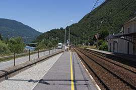 Épierre-Saint-Léger railway station | |
 Épierre Location within Auvergne-Rhône-Alpes region  Épierre | |
| Coordinates: 45°27′17″N 6°17′43″E / 45.4547°N 6.2953°ECoordinates: 45°27′17″N 6°17′43″E / 45.4547°N 6.2953°E | |
| Country | France |
| Region | Auvergne-Rhône-Alpes |
| Department | Savoie |
| Arrondissement | Saint-Jean-de-Maurienne |
| Canton | Saint-Pierre-d'Albigny |
| Intercommunality | Mont Beauvoir |
| Government | |
| • Mayor (2014–2020) | Jean Bouvier |
| Area1 | 19.36 km2 (7.47 sq mi) |
| Population (2014)2 | 776 |
| • Density | 40/km2 (100/sq mi) |
| Time zone | UTC+1 (CET) |
| • Summer (DST) | UTC+2 (CEST) |
| INSEE/Postal code | 73109 /73220 |
| Elevation | 348–2,746 m (1,142–9,009 ft) |
| Website | www.epierre-savoie.com |
|
1 French Land Register data, which excludes lakes, ponds, glaciers > 1 km2 (0.386 sq mi or 247 acres) and river estuaries. 2 Population without double counting: residents of multiple communes (e.g., students and military personnel) only counted once. | |
Épierre is a commune in the Savoie department in the Auvergne-Rhône-Alpes region in south-eastern France.
See also
References
External links
| Wikimedia Commons has media related to Épierre. |
This article is issued from
Wikipedia.
The text is licensed under Creative Commons - Attribution - Sharealike.
Additional terms may apply for the media files.