Saint-Ours, Savoie
| Saint-Ours | |
|---|---|
| Commune | |
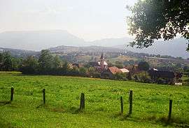 A general view of Saint-Ours | |
 Saint-Ours Location within Auvergne-Rhône-Alpes region  Saint-Ours | |
| Coordinates: 45°45′30″N 5°59′21″E / 45.7583°N 5.9892°ECoordinates: 45°45′30″N 5°59′21″E / 45.7583°N 5.9892°E | |
| Country | France |
| Region | Auvergne-Rhône-Alpes |
| Department | Savoie |
| Arrondissement | Chambéry |
| Canton | Aix-les-Bains-1 |
| Intercommunality | Canton of Albens |
| Government | |
| • Mayor (2014–2020) | Christian Rebelle |
| Area1 | 4.59 km2 (1.77 sq mi) |
| Population (2014)2 | 613 |
| • Density | 130/km2 (350/sq mi) |
| Time zone | UTC+1 (CET) |
| • Summer (DST) | UTC+2 (CEST) |
| INSEE/Postal code | 73265 /73410 |
| Elevation | 432–690 m (1,417–2,264 ft) |
|
1 French Land Register data, which excludes lakes, ponds, glaciers > 1 km2 (0.386 sq mi or 247 acres) and river estuaries. 2 Population without double counting: residents of multiple communes (e.g., students and military personnel) only counted once. | |
Saint-Ours is a commune in the Savoie department in the Auvergne-Rhône-Alpes region in south-eastern France.
It has its dynamic association of young people : Les amis du village, and its famous festival : La fête de la bâteuse
See also
References
| Wikimedia Commons has media related to Saint-Ours (Savoie). |
This article is issued from
Wikipedia.
The text is licensed under Creative Commons - Attribution - Sharealike.
Additional terms may apply for the media files.