Saint-Léonard, New Brunswick
| Saint-Léonard Ville de Saint-Léonard | ||
|---|---|---|
| Town | ||
 | ||
| ||
 Saint-Léonard Location of Saint-Léonard in New Brunswick | ||
| Coordinates: 47°09′45″N 67°55′30″W / 47.1625°N 67.925°W | ||
| Country |
| |
| Province |
| |
| County | Madawaska | |
| Parish | Saint-Léonard | |
| Settled | 1789 | |
| Town Status | 1920 | |
| Electoral Districts Federal |
Madawaska—Restigouche | |
| Provincial | Restigouche-La-Vallée | |
| Government[1] | ||
| • Type | Town Council | |
| • Mayor | Carmel St-Amand | |
| • Deputy Mayor | Kenneth Akerley | |
| • Councillors |
List of Members
| |
| Area[2] | ||
| • Total | 5.20 km2 (2.01 sq mi) | |
| Elevation | 150 to 171 m (492 to 561 ft) | |
| Population (2011)[2][3] | ||
| • Total | 1,343 | |
| • Density | 258.3/km2 (669/sq mi) | |
| • Change 2006-11 |
| |
| • Census Ranking | 1,705 of 5,008 | |
| Time zone | UTC-4 (AST) | |
| • Summer (DST) | UTC-3 (ADT) | |
| Postal code(s) | E7E | |
| Area code(s) |
| |
| Dwellings | 574 | |
| Median Income* | $33,285 CDN | |
| NTS Map | 021O04 | |
| GNBC Code | DAADY | |
| Website | www.saint-leonard.ca | |
| ||

| Wikinews has related news: Truck carrying 12 million bees overturns in New Brunswick |
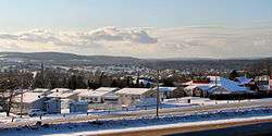
Saint-Léonard is a Canadian town in Madawaska County, New Brunswick.[4]
Geography
It is located on the east bank of the Saint John River opposite Van Buren, Maine, to which it is connected via the Saint Leonard-Van Buren Bridge.
History
Saint-Léonard was once a popular town during Prohibition in the United States as it was easy to smuggle alcohol to Van Buren.
The town's economy is driven by potato farming and a J.D. Irving Limited sawmill. Saint-Léonard is officially bilingual but it is predominantly a Francophone community.
On June 30, 2008, a truck carrying 12 million bees overturned near Saint-Léonard. This accident was the first of its kind in New Brunswick.[5]
.jpg) Saint-Léonard, 1918
Saint-Léonard, 1918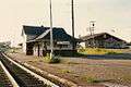 Saint-Leonard railroad station
Education
It has a single school, École Grande-Rivière.
Demographics
|
Mother tongue language (2006)[2]
|
Notable people
See also
References
- ↑ Government of New Brunswick website: Saint-Leonard Archived 2011-06-11 at the Wayback Machine.
- 1 2 3 2006 Statistics Canada Community Profile: Saint-Léonard, New Brunswick
- ↑ Statistics Canada Population and dwelling counts, for Canada, provinces and territories, and census subdivisions (municipalities), 2011 and 2006 censuses
- ↑ New Brunswick Provincial Archives - Saint-Léonard
- ↑ "Lorry carrying 12m bees overturns". BBC News Online. 2008-07-01. Retrieved 2008-07-01.
- ↑ Statistics Canada: 1996, 2001, 2006, 2011 census
- ↑ , Census 1941-1951
External links
| Wikimedia Commons has media related to Saint-Léonard (Nouveau-Brunswick). |
Places adjacent to Saint-Léonard, New Brunswick | |
|---|---|
| Subdivisions | |
|---|---|
| Cities | |
| Towns | |
| |
Coordinates: 47°09′45″N 67°55′30″W / 47.16250°N 67.92500°W