Allagash, Maine
| Allagash, Maine | |
|---|---|
| Town | |
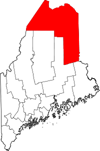
 Location of Allagash, Maine | |
| Coordinates: 47°5′35″N 69°3′30″W / 47.09306°N 69.05833°W | |
| Country |
|
| State |
|
| County | Aroostook |
| Area[1] | |
| • Total | 131.42 sq mi (340.38 km2) |
| • Land | 128.61 sq mi (333.10 km2) |
| • Water | 2.81 sq mi (7.28 km2) |
| Elevation | 1,099 ft (335 m) |
| Population (2010)[2] | |
| • Total | 239 |
| • Estimate (2012[3]) | 234 |
| • Density | 1.9/sq mi (0.7/km2) |
| Time zone | UTC-5 (Eastern (EST)) |
| • Summer (DST) | UTC-4 (EDT) |
| ZIP code | 04774 |
| Area code(s) | 207 |
| FIPS code | 23-00800 |
| GNIS feature ID | 0582320 |
| Website | http://www.allagash.info |
Allagash is a town in Aroostook County, Maine. it is on the Allagash River in the North Maine Woods region.
The population was 239 at the 2010 census.
Geography
According to the United States Census Bureau, the town has a total area of 131.42 square miles (340.38 km2), of which 128.61 square miles (333.10 km2) is land and 2.81 square miles (7.28 km2) is water.[1] This makes Allagash the largest town in Maine in terms of total land area (although when both land and water areas are included in the total, then Vinalhaven and St. George (both in coastal Knox County) are larger than Allagash).
Climate
This climatic region is typified by large seasonal temperature differences, with warm to hot (and often humid) summers and cold (sometimes severely cold) winters. According to the Köppen Climate Classification system, Allagash has a humid continental climate, abbreviated "Dfb" on climate maps.[4]
| Climate data for Allagash | |||||||||||||
|---|---|---|---|---|---|---|---|---|---|---|---|---|---|
| Month | Jan | Feb | Mar | Apr | May | Jun | Jul | Aug | Sep | Oct | Nov | Dec | Year |
| Record high °F (°C) | 54 (12) |
61 (16) |
75 (24) |
84 (29) |
92 (33) |
95 (35) |
96 (36) |
93 (34) |
93 (34) |
81 (27) |
70 (21) |
57 (14) |
96 (36) |
| Average high °F (°C) | 20 (−7) |
24 (−4) |
35 (2) |
47 (8) |
63 (17) |
72 (22) |
77 (25) |
75 (24) |
67 (19) |
52 (11) |
39 (4) |
26 (−3) |
50 (10) |
| Average low °F (°C) | −7 (−22) |
−8 (−22) |
5 (−15) |
24 (−4) |
35 (2) |
45 (7) |
50 (10) |
48 (9) |
40 (4) |
30 (−1) |
21 (−6) |
4 (−16) |
24 (−4) |
| Record low °F (°C) | −47 (−44) |
−43 (−42) |
−34 (−37) |
−5 (−21) |
13 (−11) |
17 (−8) |
28 (−2) |
28 (−2) |
22 (−6) |
9 (−13) |
−13 (−25) |
−36 (−38) |
−47 (−44) |
| Average precipitation inches (mm) | 2.38 (60.5) |
1.85 (47) |
2.03 (51.6) |
2.47 (62.7) |
2.97 (75.4) |
3.69 (93.7) |
3.98 (101.1) |
3.72 (94.5) |
3.35 (85.1) |
3.73 (94.7) |
3.13 (79.5) |
2.62 (66.5) |
34.64 (879.9) |
| Average snowfall inches (cm) | 20.73 (52.65) |
20.52 (52.12) |
16.48 (41.86) |
5.58 (14.17) |
0.47 (1.19) |
0 (0) |
0 (0) |
0 (0) |
0 (0) |
1.32 (3.35) |
10.11 (25.68) |
18.71 (47.52) |
93.92 (238.56) |
| Source: DRI [5] | |||||||||||||
Demographics
| Historical population | |||
|---|---|---|---|
| Census | Pop. | %± | |
| 1890 | 200 | — | |
| 1900 | 190 | −5.0% | |
| 1910 | 245 | 28.9% | |
| 1920 | 359 | 46.5% | |
| 1930 | 438 | 22.0% | |
| 1940 | 644 | 47.0% | |
| 1950 | 680 | 5.6% | |
| 1960 | 557 | −18.1% | |
| 1970 | 456 | −18.1% | |
| 1980 | 448 | −1.8% | |
| 1990 | 359 | −19.9% | |
| 2000 | 277 | −22.8% | |
| 2010 | 239 | −13.7% | |
| Est. 2014 | 228 | [6] | −4.6% |
| U.S. Decennial Census[7] | |||
| Languages (2000) [8] | Percent |
|---|---|
| Spoke English at home | 78.07% |
| Spoke French at home | 21.93% |
As of 2000 the median income for a household in the town was $18,125, and the median income for a family was $26,250. Males had a median income of $26,875 versus $17,813 for females. The per capita income for the town was $11,968. About 15.1% of families and 18.8% of the population were below the poverty line, including 27.3% of those under the age of eighteen and 23.5% of those sixty five or over.
2010 census
As of the census[2] of 2010, there were 239 people, 124 households, and 76 families residing in the town. The population density was 1.9 inhabitants per square mile (0.7/km2). There were 307 housing units at an average density of 2.4 per square mile (0.9/km2). The racial makeup of the town was 97.5% White, 0.4% African American, and 2.1% from two or more races. Hispanic or Latino of any race were 0.8% of the population.
There were 124 households of which 13.7% had children under the age of 18 living with them, 47.6% were married couples living together, 6.5% had a female householder with no husband present, 7.3% had a male householder with no wife present, and 38.7% were non-families. 35.5% of all households were made up of individuals and 15.3% had someone living alone who was 65 years of age or older. The average household size was 1.93 and the average family size was 2.41.
The median age in the town was 57.8 years. 11.3% of residents were under the age of 18; 3% were between the ages of 18 and 24; 16.3% were from 25 to 44; 37.7% were from 45 to 64; and 31.8% were 65 years of age or older. The gender makeup of the town was 49.0% male and 51.0% female.
References
- 1 2 "US Gazetteer files 2010". United States Census Bureau. Retrieved 2012-12-16.
- 1 2 "American FactFinder". United States Census Bureau. Retrieved 2012-12-16.
- ↑ "Population Estimates". United States Census Bureau. Archived from the original on June 17, 2013. Retrieved 2013-07-06.
- ↑ Climate Summary for Allagash, Maine
- ↑ "DRI".
- ↑ "Annual Estimates of the Resident Population for Incorporated Places: April 1, 2010 to July 1, 2014". Archived from the original on 2015-05-23. Retrieved June 4, 2015.
- ↑ "Census of Population and Housing". Census.gov. Archived from the original on May 12, 2015. Retrieved June 4, 2015.
- ↑ https://apps.mla.org/cgi-shl/docstudio/docs.pl?map_data_results. Missing or empty
|title=(help)
External links
Coordinates: 47°05′00″N 69°02′28″W / 47.08333°N 69.04111°W