Saint-André, New Brunswick
| Saint-André | ||
|---|---|---|
| Rural Community | ||
| ||
| Motto(s): "Fructus ex floribus" | ||
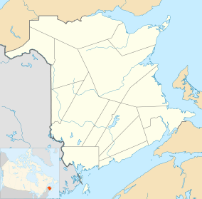
 Saint-André Location of Saint-André, New Brunswick | ||
| Coordinates: 47°06′N 67°46′W / 47.1°N 67.76°W | ||
| Country |
| |
| Province |
| |
| County | Madawaska | |
| Parish | Saint-André | |
| Founded | 1904 | |
| Incorporated | 1967 | |
| Electoral Districts Federal |
Tobique—Mactaquac | |
| Provincial | Grand Falls-Drummond-Saint-André | |
| Government[1] | ||
| • Type | Community Council | |
| • Mayor | Marcel Levesque | |
| • Councillors |
List of Members
| |
| Area[2] | ||
| • Total | 8.12 km2 (3.14 sq mi) | |
| Population (2011)[3][4] | ||
| • Total | 819 | |
| • Density | 100.8/km2 (261/sq mi) | |
| • Change 2006-11 |
| |
| • Census Ranking | 3,303 of 5,008 | |
| Time zone | UTC-4 (AST) | |
| • Summer (DST) | UTC-3 (ADT) | |
| Area code(s) | 506 | |
| Dwellings | 339 | |
| Median Income* | $48,226 CDN | |
| Website | www.sn2000.nb.ca/ comp/saint-andre | |
| ||
Saint-André (2011 pop.: 819) is a Canadian rural community in Madawaska County, New Brunswick.[5]
Situated in a potato farming area, Saint-André was founded in 1904.
Demographics
History
Notable people
See also
References
- ↑ Government of New Brunswick website: Saint-André Archived 2011-06-11 at the Wayback Machine.
- ↑ 2011 Statistics Canada Community Profile: Saint-André, New Brunswick
- 1 2 2006 Statistics Canada Community Profile: Saint-André, New Brunswick
- ↑ Statistics Canada Population and dwelling counts, for Canada, provinces and territories, and census subdivisions (municipalities), 2011 and 2006 censuses
- ↑ New Brunswick Provincial Archives - Saint-André
- ↑ Statistics Canada: 1996, 2001, 2006, 2011 census
Coordinates: 47°06′00″N 67°45′36″W / 47.10000°N 67.76000°W
This article is issued from
Wikipedia.
The text is licensed under Creative Commons - Attribution - Sharealike.
Additional terms may apply for the media files.
