Richibucto
| Richibucto | |
|---|---|
| town | |
 | |
 Richibucto Location within New Brunswick | |
| Coordinates: 46°41′N 64°52′W / 46.68°N 64.87°WCoordinates: 46°41′N 64°52′W / 46.68°N 64.87°W | |
| Country | Canada |
| Province | New Brunswick |
| County | Kent County |
| Founded | Early 1800s |
| Government | |
| • Type | Town Council |
| • Mayor | Roger Doiron |
| Area | |
| • Total | 11.83 km2 (4.57 sq mi) |
| Population (2016) | |
| • Total | 1,266 |
| • Density | 108.7/km2 (282/sq mi) |
| Time zone | UTC-4 (AST) |
| • Summer (DST) | UTC-3 (ADT) |
| Canadian Postal code | E4W |
| Area code(s) | 506 |
| Website |
www |
Richibucto is a town in Kent County, New Brunswick, Canada.[1]
Geography
The town is situated on the Richibucto River where it discharges into the Northumberland Strait.
History
Richibucto had been the location of an annual Mi'kmaq summer coastal community prior to European settlement.[2] The town takes its name from "Elsipogtog" or "L'sipuktuk" Mi'kmaq terms meaning "river of fire".[3] It is believed the term was mispronounced, or misunderstood from the Mi'kmaq language. See Elsipogtog First Nation.
Present day
The downtown area, situated on the mouth of the river, has commercial fishing wharves, several restaurants, and local stores. The economy is dominated by lobster and deep sea fishing.
Demographics
Population trend [4]
| Census | Population | Change (%) |
|---|---|---|
| 2016 | 1,266 | |
| 2011 | 1,286 | |
| 2006 | 1,290 | |
| 2001 | 1,341 | |
| 1996 | 1,414 | |
| 1991 | 1,469 | |
| 1986 | 1,609 | |
| 1981 | 1,722 |
|
Religious make-up (2001)
|
Income (2006)
|
Mother tongue language (2011)[5]
|
Attractions
 Richibucto Head Lighthouse in 2007 | |
|
New Brunswick | |
| Location |
Richibucto New Brunswick Canada |
|---|---|
| Coordinates | 46°40′11.25″N 64°42′41.84″W / 46.6697917°N 64.7116222°W |
| Year first constructed | 1865 (first) |
| Year first lit | 1901 (current) |
| Deactivated | 1901 (first) |
| Foundation | masonry base |
| Construction | wooden tower |
| Tower shape | square frustum tower with balcony and lantern |
| Markings / pattern | white tower, red lantern |
| Height | 10.3 metres (34 ft) |
| Focal height | 18 metres (59 ft) |
| Original lens | fourth-order Fresnel lens |
| Light source | main power |
| Range | 14 nautical miles (26 km; 16 mi)[6] |
| Characteristic | Fl W 5s. |
| Admiralty number | H1376 |
| CHS number | CCG 1128 |
| NGA number | 7660 |
| ARLHS number | CAN-430 |
| Managing agent | Canadian Coast Guard[7][8] |
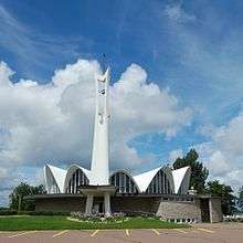
- St. Louis de Gonzague Roman Catholic Church was completed in 1965. Designed by Belanger and Roy of Moncton, it was inspired by the designs of the Spanish architect, Félix Candela.[9]
Notable people
- William Chandler (1804–1856), lawyer, judge
- James Hannay (1842–1910), lawyer
- John Livingston (1837–1894), journalist, editor
- Murray MacLaren (1861–1942), doctor, politician
- George McLeod (1836–1905),
- James D. Phinney (November 17, 1844 – ) lawyer, judge, politician
- Henry Powell (1855–1930), politician
- Louis Robichaud (1925–2005), former Premier of New Brunswick
- John P. Tenass (1849–1928), Indian chief
- Peter Veniot (1863–1926), former Premier of New Brunswick
- Charles Wesley Weldon (1830–1896), lawyer, politician
See also
References
- ↑ Richibucto Town Website
- ↑ "Micmac Locations". Micmac Tribe. Access Genealogy. Retrieved 27 May 2014.
- ↑ History of Richibucto Archived 2007-09-28 at the Wayback Machine.
- ↑ Statistics Canada: 1996, 2001, 2006 census
- ↑ Statistics Canada: 2011 census
- ↑ List of Lights, Pub. 110: Greenland, The East Coasts of North and South America (Excluding Continental U.S.A. Except the East Coast of Florida) and the West Indies (PDF). List of Lights. United States National Geospatial-Intelligence Agency. 2015.
- ↑ "Northern New Brunswick". The Lighthouse Directory. University of North Carolina at Chapel Hill. Retrieved 30 March 2017.
- ↑ "Richibucto Head, NB". Lighthouse Friends. Retrieved 30 March 2017.
- ↑ John Leroux, Building New Brunswick: An Architectural History, Goose Lane, 2008, p. 216-219
External links
- Aids to Navigation Canadian Coast Guard
| Wikisource has the text of the 1905 New International Encyclopedia article Richibucto. |
| Wikimedia Commons has media related to Richibucto. |
| Subdivisions | |
|---|---|
| Cities | |
| Towns | |
| |