Madawaska County, New Brunswick
| Madawaska | |
|---|---|
| County | |
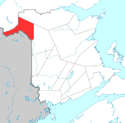 Location of Madawaska County. | |
| Country |
|
| Province |
|
| Established | 1873 |
| Area[1] | |
| • Land | 3,463.05 km2 (1,337.09 sq mi) |
| Population (2011)[1] | |
| • Total | 33,422 |
| • Density | 9.7/km2 (25/sq mi) |
| • Pop 2006-2011 |
|
| • Dwellings | 15,514 |
| Time zone | UTC-4 (AST) |
| • Summer (DST) | UTC-3 (ADT) |
| Area code(s) | 506 |
Madawaska County (2011 population 33,422),[2] also known as the "New Brunswick Panhandle",[3] is located in northwestern New Brunswick, Canada. Over 90% of the county's population speaks French. Its Francophone population are known as "Brayons." Forestry is the major industry in the county.
History
The first inhabitants of what is now called Madawaska County were the Maliseet or Wolastoqiyik, who occupied and used the land along the Saint John River Valley north to the St. Lawrence River and south to the Penobscot River. There is debate concerning the true origin of the word "Madawaska". The earliest settlers were from Quebec. The area was the focus of the bloodless Aroostook War, a border dispute led by businessman and political activist John Baker.
The earliest settlers of the Upper Saint John River Valley can be clearly verified with [4] and [5]
The second link displays census results taken in 1820 of the Madawaska region where most families had originated from Quebec.
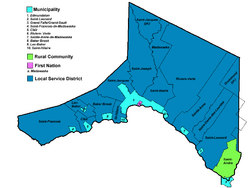
Census subdivisions
Communities
There are ten municipalities within Madawaska County (listed by 2011 population):[6]
| Official Name | Designation | Area km2 | Pop 2011 | Parish |
|---|---|---|---|---|
| Edmundston | City | 107.00 | 16,032 | Madawaska, Saint-Basile, Saint-Jacques, Saint-Joseph |
| Saint-Léonard | Town | 5.20 | 1,343 | Saint-Léonard |
| Sainte-Anne-de-Madawaska | Village | 9.21 | 1,002 | Sainte-Anne |
| Clair | Village | 10.39 | 857 | Clair |
| Saint-André | Rural community | 8.12 | 819 | Saint-André Parish |
| Rivière-Verte | Village | 7.00 | 744 | Rivière-Verte |
| Lac-Baker | Village | 37.12 | 719 | Lac-Baker |
| Baker-Brook | Village | 12.29 | 585 | Baker Brook |
| Saint-François-de-Madawaska | Village | 6.34 | 533 | Saint-François |
| Saint-Hilaire | Village | 5.67 | 303 | Saint-Hilaire |
First Nations
There is one First Nations reserve in Madawaska County (listed by 2011 population):[6]
| Official Name | Designation | Area km2 | Pop 2011 | Parish |
|---|---|---|---|---|
| St. Basile 10 | Reserve | 3.21 | 205 | Saint-Basile |
Parishes
The county is subdivided into fourteen parishes (listed by 2011 population):[6]
| Official Name | Area km2 | Pop 2011 | Municipalities or equivalents | Unincorporated communities |
|---|---|---|---|---|
| Saint-Joseph | 322.89 | 2,171 | Edmundston | Deuxième-Sault / Francoeur / Lévesque / Rang-des-Bossé / Rang-des-Couturier / Saint-Joseph-de-Madawaska / Sicard / Toussaint / Violette |
| Saint-Jacques | 299.80 | 1,599 | Edmundston | Ennemond / Grandmaison / Moulin-Morneault / Patrieville / Petite-Rivière-à-la-Truite / Saint-Jacques / St. Joseph Settlement |
| Saint-André | 128.08 | 1,134 | Saint-André | Comeau Ridge / Gaudreau Park / Lévesque Settlement / McManus Siding / Powers Creek / Saint-Amand / Woodville |
| Saint-Léonard | 343.97 | 1,052 | Saint-Léonard | Bellefleur / Coombes Road / Cyr Junction / Grand-Ruisseau / Martin Siding / Poitras / Rang-des-Bourgoin / Saint-Léonard-Parent |
| Sainte-Anne | 369.30 | 949 | Sainte-Anne-de-Madawaska | Fourche-à-Clark / Miller Line Cache / Prime / Rang-des-Deschêne / Ringuette Settlement / Siegas / Siegas Lake Settlement / Sirois |
| Saint-Basile | 129.74 | 717 | Edmundston St. Basile 10 (native reserve) |
Boniface Bridge / Green River Settlement / Jalbert / Maillet / Montagne-des-Therrien / Rang-des-Lavoie / |
| Rivière-Verte | 715.60 | 686 | Rivière-Verte | Beardsley Depot / Davis Mill / Montagne-de-la-Croix / Montagne-des-Roy / Rang-des-Hubert |
| Saint-François | 344.70 | 630 | Haut-Madawaska | Concession-des-Jaunes / Concession-des-Viel / Connors / Lac-Unique / Little River Mills / Mouth of St. Francis / Pelletiers Mill / Val Oakes |
| Saint-Hilaire | 41.55 | 490 | Haut-Madawaska | Riceville |
| Clair | 44.18 | 297 | Haut-Madawaska | Caron Brook / Concession-des-Lang / Concession-des-Vasseur / Crockett / Les Rapides |
| Baker Brook | 125.48 | 287 | Haut-Madawaska | Concession-de-Baker-Brook / Concession-des-Ouellette / Rang-des-Morneault / Rang-Saint-Joseph / Val-Lambert / Val-Nadeau |
| Notre-Dame-de-Lourdes | 188.63 | 263 | Durette Settlement / Flemming / Harrison Brook Settlement / La Montagne / Lower Siegas / Notre-Dame-de-Lourdes | |
| Lac-Baker | 24.29 | 5 | Lac-Baker Haut-Madawaska |
Boundary / Portage-du-Lac / Rang-des-Collin / Saint-Castin / Pelletiers Mill / Soucy |
| Madawaska | 173.32 | 0 | Edmundston Haut-Madawaska |
Demographics
Population
| Canada census – Madawaska County, New Brunswick community profile | |||
|---|---|---|---|
| 2011 | 2006 | ||
| Population: | 33,422 (-1.9% from 2006) | 34,071 (-4.3% from 2001) | |
| Land area: | 3,463.05 km2 (1,337.09 sq mi) | 3,461.46 km2 (1,336.48 sq mi) | |
| Population density: | 9.7/km2 (25/sq mi) | 9.8/km2 (25/sq mi) | |
| Median age: | 47.3 (M: 46.3, F: 48.1) | 43.9 (M: 43.1, F: 44.6) | |
| Total private dwellings: | 15,514 | 15,888 | |
| Median household income: | $47,385 | $42,709 | |
| References: 2011[1] 2006[7] earlier[8] | |||
| Historical Census Data - Madawaska County, New Brunswick[9] | ||||||||||||||||||||||||||
|---|---|---|---|---|---|---|---|---|---|---|---|---|---|---|---|---|---|---|---|---|---|---|---|---|---|---|
|
|
| ||||||||||||||||||||||||
Language
| Canada Census Mother Tongue - Madawaska County, New Brunswick[9] | ||||||||||||||||||
|---|---|---|---|---|---|---|---|---|---|---|---|---|---|---|---|---|---|---|
| Census | Total | French |
English |
French & English |
Other | |||||||||||||
| Year | Responses | Count | Trend | Pop % | Count | Trend | Pop % | Count | Trend | Pop % | Count | Trend | Pop % | |||||
2011 |
32,510 |
30,500 | 93.82% | 1,530 | 4.71% | 300 | 0.92% | 180 | 0.55% | |||||||||
2006 |
33,510 |
31,185 | 93.06% | 1,665 | 4.97% | 265 | 0.79% | 395 | 1.18% | |||||||||
2001 |
34,845 |
32,735 | 93.94% | 1,570 | 4.51% | 360 | 1.03% | 180 | 0.52% | |||||||||
1996 |
36,300 |
34,030 | n/a | 93.75% | 1,830 | n/a | 5.04% | 315 | n/a | 0.87% | 125 | n/a | 0.34% | |||||
Access routes
Highways and numbered routes that run through the county, including external routes that start or finish at the county limits:[10]
|
|
|
|
Protected areas and attractions
Notable people
See also
| Wikimedia Commons has media related to Madawaska County, New Brunswick. |
References
- 1 2 3 "2011 Community Profiles". Canada 2011 Census. Statistics Canada. July 5, 2013. Retrieved 2014-03-26.
- ↑ Canada, Government of Canada, Statistics. "Statistics Canada: 2011 Census Profile". www12.statcan.gc.ca. Retrieved 2017-02-06.
- ↑ "Rivers of Canada - St. John River : Can Geo Education". www.cangeoeducation.ca. Retrieved 2017-02-06.
- ↑ http://www.upperstjohn.com/visits/Saint-Vallier1686.htm
- ↑ http://www.upperstjohn.com/1820/madawaska.htm
- 1 2 3 New Brunswick Provincial Archives - Madawaska County
- ↑ "2006 Community Profiles". Canada 2006 Census. Statistics Canada. March 30, 2011. Retrieved 2014-03-26.
- ↑ "2001 Community Profiles". Canada 2001 Census. Statistics Canada. February 17, 2012.
- 1 2 Statistics Canada: 1996, 2001, 2006, 2011 census
- ↑ Atlantic Canada Back Road Atlas ISBN 978-1-55368-618-7
External links
- Madawaska County Guide
- http://www.transmission.bpa.gov/cigresc14/Compendium/MADAWAS.htm%5Bpermanent+dead+link%5D
- https://web.archive.org/web/20050930023543/http://www.transmission.bpa.gov/cigresc14/Compendium/Madawas%20Pictures.pdf
Places adjacent to Madawaska County, New Brunswick | |
|---|---|
| Subdivisions | |
|---|---|
| Cities | |
| Counties | |
| |
Coordinates: 47°25′17.1″N 68°21′38.2″W / 47.421417°N 68.360611°W