Saint-Honoré-de-Shenley, Quebec
| Saint-Honoré-de-Shenley | |
|---|---|
| Municipality | |
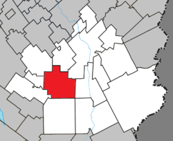 Location within Beauce-Sartigan RCM. | |
 Saint-Honoré-de-Shenley Location in southern Quebec. | |
| Coordinates: 45°58′N 70°50′W / 45.967°N 70.833°WCoordinates: 45°58′N 70°50′W / 45.967°N 70.833°W[1] | |
| Country |
|
| Province |
|
| Region | Chaudière-Appalaches |
| RCM | Beauce-Sartigan |
| Constituted | April 19, 2000 |
| Government[2] | |
| • Mayor | Dany Quirion |
| • Federal riding | Beauce |
| • Prov. riding | Beauce-Sud |
| Area[2][3] | |
| • Total | 133.70 km2 (51.62 sq mi) |
| • Land | 133.10 km2 (51.39 sq mi) |
| Population (2011)[3] | |
| • Total | 1,610 |
| • Density | 12.1/km2 (31/sq mi) |
| • Pop 2006-2011 |
|
| • Dwellings | 668 |
| Time zone | UTC−5 (EST) |
| • Summer (DST) | UTC−4 (EDT) |
| Postal code(s) | G0M 1V0 |
| Area code(s) | 418 and 581 |
| Highways |
|
| Website |
www.sthonore deshenley.com |
Saint-Honoré-de-Shenley is a municipality in the Beauce-Sartigan Regional County Municipality in the Chaudière-Appalaches region of Quebec, Canada. Its population is 1,610 as of 2011.
The municipality was created in 2000 after the merging of the parish municipality of Saint-Honoré and the township municipality of Shenley. It is named after Honoré Desruisseaux, the first reverend of the parish in 1869, and the village of Shenley, in Hertfordshire, England.
References
Places adjacent to Saint-Honoré-de-Shenley, Quebec | |
|---|---|
| Cities & Towns | |
|---|---|
| Municipalities | |
| Parishes | |
| Villages | |
| |
This article is issued from
Wikipedia.
The text is licensed under Creative Commons - Attribution - Sharealike.
Additional terms may apply for the media files.