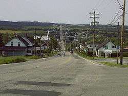
La Guadeloupe, Quebec
| La Guadeloupe | |
|---|---|
| Village municipality | |
 | |
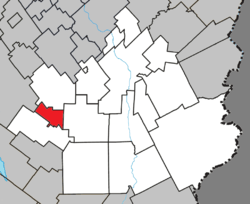 Location within Beauce-Sartigan RCM | |
 La Guadeloupe Location in southern Quebec | |
| Coordinates: 45°57′N 70°56′W / 45.95°N 70.93°WCoordinates: 45°57′N 70°56′W / 45.95°N 70.93°W[1] | |
| Country |
|
| Province |
|
| Region | Chaudière-Appalaches |
| RCM | Beauce-Sartigan |
| Constituted | August 6, 1929 |
| Government[2] | |
| • Mayor | Huguette Plante |
| • Federal riding | Beauce |
| • Prov. riding | Beauce-Sud |
| Area[2][3] | |
| • Total | 32.70 km2 (12.63 sq mi) |
| • Land | 32.62 km2 (12.59 sq mi) |
| Population (2011)[3] | |
| • Total | 1,787 |
| • Density | 54.8/km2 (142/sq mi) |
| • Pop 2006-2011 |
|
| • Dwellings | 801 |
| Time zone | UTC−5 (EST) |
| • Summer (DST) | UTC−4 (EDT) |
| Postal code(s) | G0M 1G0 |
| Area code(s) | 418 and 581 |
| Highways |
|
| Census profile | 2429030[3] |
| MAMROT info | 29030[2] |
| Toponymie info | 33607[1] |
| Website |
www |
La Guadeloupe is a village in the Beauce-Sartigan Regional County Municipality in the Chaudière-Appalaches region of Quebec, Canada. Its population is 1,787 as of 2011.
References
External links

Places adjacent to La Guadeloupe, Quebec | |
|---|---|
| Cities & Towns | |
|---|---|
| Municipalities | |
| Parishes | |
| Villages | |
| |
This article is issued from
Wikipedia.
The text is licensed under Creative Commons - Attribution - Sharealike.
Additional terms may apply for the media files.