Notre-Dame-des-Pins, Quebec
| Notre-Dame-des-Pins | |
|---|---|
| Parish municipality | |
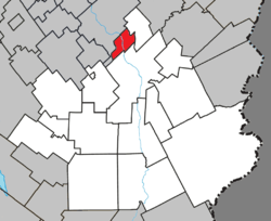 Location within Beauce-Sartigan RCM. | |
 Notre-Dame-des-Pins Location in southern Quebec. | |
| Coordinates: 46°11′N 70°43′W / 46.183°N 70.717°WCoordinates: 46°11′N 70°43′W / 46.183°N 70.717°W[1] | |
| Country |
|
| Province |
|
| Region | Chaudière-Appalaches |
| RCM | Beauce-Sartigan |
| Constituted | June 29, 1926 |
| Government[2] | |
| • Mayor | Pierre Bégin |
| • Federal riding | Beauce |
| • Prov. riding | Beauce-Sud |
| Area[2][3] | |
| • Total | 25.00 km2 (9.65 sq mi) |
| • Land | 23.95 km2 (9.25 sq mi) |
| Population (2011)[3] | |
| • Total | 1,227 |
| • Density | 51.2/km2 (133/sq mi) |
| • Pop 2006-2011 |
|
| • Dwellings | 453 |
| Time zone | UTC−5 (EST) |
| • Summer (DST) | UTC−4 (EDT) |
| Postal code(s) | G0M 1K0 |
| Area code(s) | 418 and 581 |
| Highways |
|
| Website |
www.notredame despins.qc.ca |
Notre-Dame-des-Pins is a parish municipality in the Beauce-Sartigan Regional County Municipality in the Chaudière-Appalaches region of Quebec, Canada. Its population is 1,227 as of the Canada 2011 Census.
Notre-Dame-des-Pins is known for its covered bridge crossing the Chaudière River. Built in 1928 and opened in 1929, it is 146 metres long. It is the longest of its kind in Quebec, and the second longest in Canada.
References
- Commission de toponymie du Québec
- Ministère des Affaires municipales, des Régions et de l'Occupation du territoire
Places adjacent to Notre-Dame-des-Pins, Quebec | ||||||||||
|---|---|---|---|---|---|---|---|---|---|---|
| ||||||||||
| Cities & Towns | |
|---|---|
| Municipalities | |
| Parishes | |
| Villages | |
| |
This article is issued from
Wikipedia.
The text is licensed under Creative Commons - Attribution - Sharealike.
Additional terms may apply for the media files.