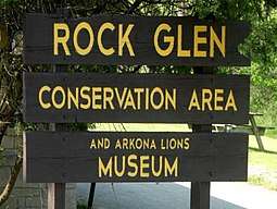
Rock Glen Conservation Area
| Rock Glen Conservation Area | |
| Protected Area | |
 Rock Glen Conservation Area (Arkona, Ontario, Canada). | |
| Name origin: Former Rock Glen Power Company, 1907.[1] | |
| Country | Canada |
|---|---|
| Province | Ontario |
| Regional municipality | Lambton Shores |
| City | Arkona, Ontario |
| Elevation | 181[2] m (594 ft) |
| Coordinates | 43°05′03.46″N 81°49′17.28″W / 43.0842944°N 81.8214667°WCoordinates: 43°05′03.46″N 81°49′17.28″W / 43.0842944°N 81.8214667°W[3] |
| Area | 27[4] ha (67 acres) |
| Founded | 2011[1] |
| Management | Ausable Bayfield Conservation Authority[1] |
 Location in Ontario, Canada | |
| Website: abca | |
Rock Glen Conservation Area is a suburban conservation area located in the town of Arkona, in the municipality of Lambton Shores, Ontario, Canada. The conservation is owned and maintained by the Ausable Bayfield Conservation Authority (ABCA).[5] The former "Ausable River Conservation Authority" was Ontario's first conservation authority. It was created in 1946. The Bayfield River watershed and smaller streams were added in 1971. Local municipalities and the Province of Ontario formed "Ausable Bayfield Conservation Authority" (ABCA) to prevent the loss of important local ecosystems, to protect life and property through flood management, and to build a healthier natural environment on a watershed scale.[6] Rock Glen Conservation Area is situated in a transition zone between the Carolinian forest zone to the south, and the Great Lakes (St. Lawrence Zone to the north), in Lambton Shores, Ontario, Canada.[1] On the conservation grounds is the Arkona Lions Museum and Information Centre; which houses a collection of Devonian Era fossils and Aboriginal artifacts found in the local area.[5]
History
Civilization around Rock Glen dates back to the time when Paleolithic or Early First Nations peoples utilized the nearby hills to hunt the barren ground for caribou some 10,000-years-ago.[7][8]Succeeding the Paleolithic humans at the end of the Pleistocene were the Archaic First Nations who had adapted to a much milder climate some 6,000-years-ago. The museum at the conservation displays "fluted points" associated with the Pleistocene people and many Clovis Point Meadow Cache Blades[9] from the Archaic aboriginal peoples.[7]
This area features some of the best Devonian-Era fossils in North America. It is home to a fossil deposit dating to 350-million-years-ago. The erosive powers of water has exposed a geological formation called the "Hungry Hollow Formation"[10][11][12][13][14] and washed out many of the different fossils contained there. The most commonly found fossils are brachiopods, horn corals (Heliophyllum halli), and crinoid stem sections; which are remains of the marine life of the Devonian geological period. Trilobites have also been found.[15][1][7][16][17]
When the pioneer settlers arrived in the area in the mid-1800s, they built some grist mills within the present-day conservation area. One of these mills was run by an 11-metre overshot wheel. The mill pond, although dry, can still be seen immediately upstream and southwest of Rock Glen Falls. Part of the mill foundation has a platform that affords visitors an excellent view of the waterfalls. In 1907, the Rock Glen Power Company constructed a small hydro-electric dam on the Ausable River at Rock Glen. Following the formation of Ontario Hydro, the Rock Glen dam ceased operation shortly after the Second World War. In response to complaints from anglers that fish were unable to travel upstream to spawn, a Canadian Army demolition squad blew up the dam with dynamite. Parts of the old dam can still be seen in the bottom of the Ausable River.[1][7][16][17]
- Photo Gallery of Rock Glen Conservation Area
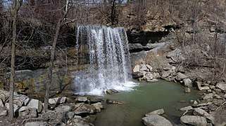 The Waterfalls
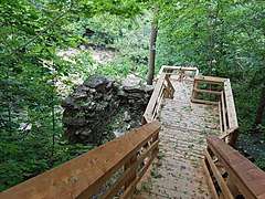 Stairs to glen
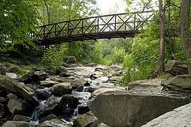 A Bridge
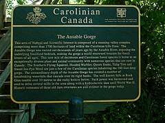 Info Plaque
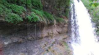 Waterfalls
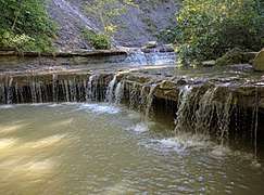 A river
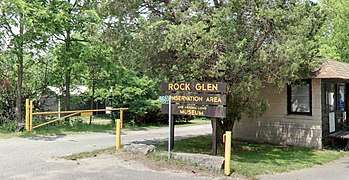 The entrance
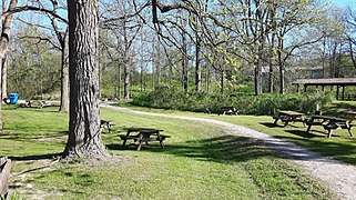 Picnic Grounds
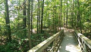 Boardwalk Trail
Flora and fauna
The conservation area is home to a large diversity of species representative of both zones, and are found alongside sugar maple, beech, white elm and basswood, some of these native trees are: Sycamore, Sassafras, Cucumber Magnolia, Tulip-tree, Black Walnut, Maple, Oak, Ash, Pine, and Pawpaw.[18][16][1] [19][15] Wildflowers are abundant, with more than 50-types found within the boundaries of Rock Glen Conservation Area. Small mammals and songbirds are common. There are also examples of extinct animal life along the walls of the Ausable Gorge, small sea creatures that lived 350-million-years-ago. Fossils of some of these ancient animals include: brachiopods, horn corals, sponge coral, crinoids or gastropods. [1][20][21]
The park is home to the eastern coyote, wood duck, deer, muskrat, and common garter snake.
Birds
Dozens of bird species can be seen.
- Eastern meadowlark
- Red-winged blackbird
- Bobolink
- American woodcock
- Savannah sparrow
- Rose-breasted grosbeak
- Pileated woodpecker
- Red-eyed vireo
- Blue jay
- American robin
- Great-crested flycatcher
- Hairy woodpecker
- Scarlet tanager
- Northern oriole
- Eastern kingbird
- Field sparrow
- House wren
- Yellow shafted flicker
- Indigo bunting
- Grey catbird
- Brown thrasher
Facilities
Located on the conservation grounds is the Arkona Lions Museum and Information Centre, which contains a large collection of birds and wildlife preserved with traditional taxidermic methods. The museum also has a large collection of fossils and artifacts found on or near the conservation grounds, and holds presentations and guided tours there for visitors and schools. The grounds also has many stairs, boardwalks and bridges allowing visitors to safely explore the steep sides of the glen and the 10.7-metre high waterfall just upstream of the Ausable River. Many of fossils found in the exposed beds there date back 350-Million-Years; some of which include crinoids, brachiopods and trilobites[22], which the conservation park allows visitors to take one fossil if visibility seen without digging.[1][4] There's also Public washrooms, two picnic pavilions available for reservation, playground equipment by the pavilions, the lookouts located at different parts of the conservation area, and lots of trails for hiking. Rock Glen Conservation Area also has guided and educational hikes available for groups and schools.[1][4][23][24][25][20][26]
- Arkona Lions Museum and Information Centre
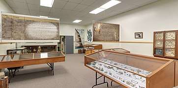 Arkona Lions Museum
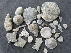 Fossils
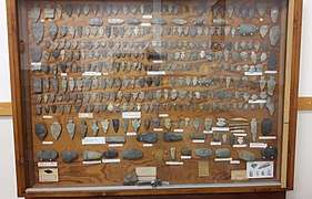 Cache Blades
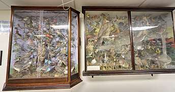 Preserved Birds
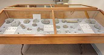 Fossils
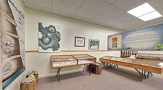 Inside museum
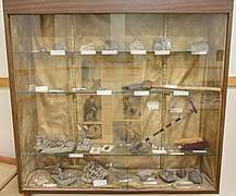 Artifacts
See also
- Ausable River
- Hungry Hollow Formation
- Ausable Bayfield Conservation Authority
- Devonian Era
- Pleistocene
- Timeline of Ontario history
- Paleo-Indians
- List of place names in Canada of Indigenous origin
- Lambton County
- Wisconsin Glacier
- Arkona, Ontario
- Southern Ontario
- Southwestern Ontario
- Bosanquet, Ontario
- Lambton Shores
References
- 1 2 3 4 5 6 7 8 9 10 http://www.abca.on.ca/downloads/Rock-Glen-CA-Brochure-2015.pdf
- ↑ "Worldwide Elevation Finder". elevation.maplogs.com.
- ↑ "Rock Glen Conservation Area". www.abca.on.ca.
- 1 2 3 "Rock Glen Conservation Area - Ontario Trails Council". www.ontariotrails.on.ca.
- 1 2 "Rock Glen Conservation Area". Lambton Shores.
- ↑ "History". www.abca.on.ca.
- 1 2 3 4 "Rock Glen Conservation Area". www.abca.on.ca.
- ↑ Many of their hunting arrows and tools can be seen on display at the "Arkona Lions Museum" located on the conservation grounds.
- ↑ "Meadow Cache Blades". www.ssc.uwo.ca.
- ↑ "The Nautiloid Network". nautiloid.net.
- ↑ "Ontario's Hungry Hollow "formation" ?". The Fossil Forum.
- ↑ "Hungry Hollow". The Fossil Guy.
- ↑ "Hunting the Hollow". Kane X. Faucher.
- ↑ "Fossils in Ontario - Earth Sciences Museum". 27 February 2013.
- 1 2 Johnson, Lorraine. The natural treasures of Carolinian Canada: discovering the rich natural diversity of Ontarios Southwestern heartland. Toronto, J. Lorimer & Co., 2007.
- 1 2 3 "Land Stewardship Fact Sheets". caroliniancanada.ca.
- 1 2 "Devonian". 24 August 2017 – via Wikipedia.
- ↑ https://caroliniancanada.ca/legacy/Publications/LC_Final_Factsheet_070425.pdf
- ↑ "Carolinian Zone". www.abca.on.ca.
- 1 2 "Outdoor Conservation Education Programs". www.abca.on.ca.
- ↑ "The Big Picture project - Conservation Programs". caroliniancanada.ca.
- ↑ "Ausable River (Lake Huron)". 21 May 2017 – via Wikipedia.
- ↑ "Rock Glen Conservation Area". www.bluewatertourism.com.
- ↑ "Rock Glen Conservation Area". ontarioconservationareas.ca.
- ↑ "Education Programs". www.abca.on.ca.
- ↑ http://www.abca.on.ca/downloads/ED_Outdoor_Program_Descriptions_A_to_D.pdf
External links
| National parks | 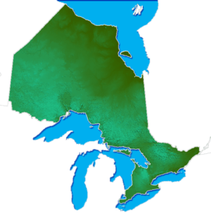 | |
|---|---|---|
| Provincial parks | ||
| Conservation areas | ||
| UNESCO Biosphere Reserves | ||
| National Historic Sites | ||
| Other areas | ||
| Former parks | ||
| ||