| Name |
Address |
Coordinates |
IDF |
IDP |
IDM |
 |
Image |
|---|
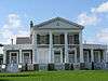
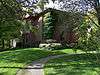
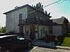
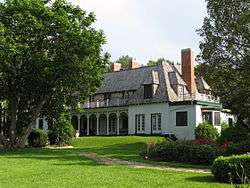
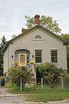
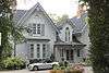
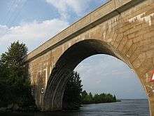
| Barnum House |
10568 Highway 2, Alnwick/Haldimand, ON |
43°59′26.9″N 78°2′37.0″W / 43.990806°N 78.043611°W / 43.990806; -78.043611 (Barnum House) |
4027 |
19799 |
|
Q4409745 |
More images |
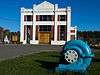
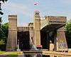
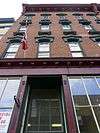
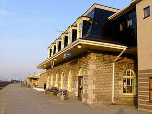
| Former Canadian National Railways (VIA Rail) Station |
201 Third Street, Cobourg, ON |
43°58′03″N 78°10′17″W / 43.9676°N 78.1714°W / 43.9676; -78.1714 (Former Canadian National Railways (VIA Rail) Station (Cobourg)) |
4617 |
|
|
|
 |
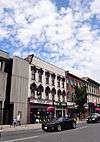
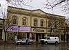
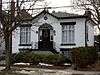
| Old Market Building |
201 Third Street, Cobourg, ON |
43°57′34″N 78°10′04″W / 43.9595°N 78.1679°W / 43.9595; -78.1679 (Old Market Building) |
|
8184 |
|
|

More images |
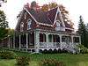
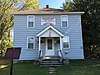
| Poplars |
18 Spencer Street East, Cobourg, ON |
43°57′54″N 78°10′09″W / 43.9651°N 78.1691°W / 43.9651; -78.1691 (Poplars) |
|
8897 |
|
|
 |
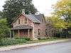
| Second Street Fire Hall |
213 Second Street, Cobourg, ON |
43°57′34″N 78°10′04″W / 43.9595°N 78.1679°W / 43.9595; -78.1679 (Second Street Fire Hall) |
|
10570 |
|
|
.jpg) |
| Victoria College |
100 University Street East, Cobourg, ON |
43°57′55″N 78°09′53″W / 43.9654°N 78.1646°W / 43.9654; -78.1646 (Victoria College) |
|
8208 |
|
|
|
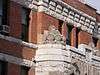
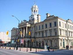
| Victoria Hall / Cobourg Town Hall National Historic Site of Canada |
55 King Street, Cobourg, ON |
43°57′34″N 78°10′04″W / 43.9595°N 78.1679°W / 43.9595; -78.1679 (Victoria Hall / Cobourg Town Hall National Historic Site of Canada) |
7550 |
8201 |
|
|
More images |
| 26 Barrett Street |
26 Barrett Street, Port Hope, ON |
43°57′15″N 78°17′43″W / 43.9541°N 78.2954°W / 43.9541; -78.2954 (26 Barrett Street) |
|
|
9329 |
|
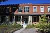 |
| 34-46 Walton Street, Port Hope |
34 Walton Street, Port Hope, ON |
43°57′05″N 78°17′35″W / 43.9513°N 78.2931°W / 43.9513; -78.2931 (34-46 Walton Street, Port Hope) |
|
8836 |
|
|

More images |
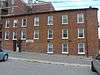
| 50 John Street |
50 John Street, Port Hope, ON |
43°57′03″N 78°17′42″W / 43.9508°N 78.2949°W / 43.9508; -78.2949 (50 John Street) |
|
8266 |
|
|
|
| Armstrong Cottage |
239 Ridout Street, Port Hope, ON |
43°57′05″N 78°18′13″W / 43.9515°N 78.3035°W / 43.9515; -78.3035 (Armstrong Cottage) |
|
|
9327 |
|
 |
| Bank of Upper Canada |
86 John Street, Port Hope, ON |
43°56′59″N 78°17′43″W / 43.9496°N 78.2952°W / 43.9496; -78.2952 (Bank of Upper Canada) |
|
|
9328 |
|
 |
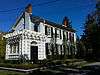
| Blackham's Hotel |
4345 Dorset Street West, Port Hope, ON |
43°56′54″N 78°17′45″W / 43.9483°N 78.2957°W / 43.9483; -78.2957 (Blackham's Hotel) |
|
|
8945 |
|
 |
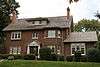
| Bluestone House |
21 Dorset Street East, Port Hope, ON |
43°56′59″N 78°17′23″W / 43.9498°N 78.2898°W / 43.9498; -78.2898 (Bluestone House) |
|
19801 |
|
|
|
| Cassie Cottage |
15 Julia Street, Port Hope, ON |
43°57′09″N 78°18′15″W / 43.9525°N 78.3043°W / 43.9525; -78.3043 (Cassie Cottage) |
|
|
8946 |
|
 |
| Chalk Carriage Works |
46 Cavan Street, Port Hope, ON |
43°57′13″N 78°17′44″W / 43.9537°N 78.2956°W / 43.9537; -78.2956 (Chalk Carriage Works) |
|
|
9331 |
|
More images |
| Charles Clemes Duplex |
57 King Street, Port Hope, ON |
43°57′03″N 78°17′25″W / 43.9507°N 78.2902°W / 43.9507; -78.2902 (Charles Clemes Duplex) |
|
|
9332 |
|

More images |
| Charles Wickett House |
55 King Street, Port Hope, ON |
43°57′03″N 78°17′25″W / 43.9508°N 78.2902°W / 43.9508; -78.2902 (Charles Wickett House) |
|
|
9993 |
|
More images |
| Crawley House |
28 Bedford Street, Port Hope, ON |
43°57′22″N 78°17′54″W / 43.9562°N 78.2984°W / 43.9562; -78.2984 (Crawley House) |
|
|
9994 |
|
 |
| David Smart House |
175 Dorset Street West, Port Hope, ON |
43°56′47″N 78°18′08″W / 43.9463°N 78.3021°W / 43.9463; -78.3021 (David Smart House) |
|
|
7789 |
|
 |
| Elias Smith House |
168 King Street, Port Hope, ON |
43°56′42″N 78°17′24″W / 43.9449°N 78.290°W / 43.9449; -78.290 (Elias Smith House) |
|
|
9995 |
|
|
| Fairmont: The David Smith House |
172 Dorset Street, Port Hope, ON |
43°57′09″N 78°16′48″W / 43.9524°N 78.28°W / 43.9524; -78.28 (Fairmont: The David Smith House) |
|
|
9997 |
|
 |
| George Manning Furby House |
61 Bramley Street North, Port Hope, ON |
43°57′14″N 78°18′26″W / 43.9539°N 78.3073°W / 43.9539; -78.3073 (George Manning Furby House) |
|
|
9998 |
|

More images |
| Henry Howard Meredith House |
47 Pine Street South, Port Hope, ON |
43°57′01″N 78°17′46″W / 43.9502°N 78.2961°W / 43.9502; -78.2961 (Henry Howard Meredith House) |
|
|
10002 |
|
 |
| Hooey Cottage |
20 Ward Street (accessed from 31A Harcourt St.), Port Hope, ON |
43°57′14″N 78°17′28″W / 43.9539°N 78.2911°W / 43.9539; -78.2911 (Hooey Cottage) |
|
|
10003 |
|
 |
| James Leslie Cottage |
118 Bruton Street, Port Hope, ON |
43°57′13″N 78°18′21″W / 43.9535°N 78.3057°W / 43.9535; -78.3057 (James Leslie Cottage) |
|
|
10004 |
|
 |
| James Sculthorp Townhouse |
200 Walton Street, Port Hope, ON |
43°57′08″N 78°18′03″W / 43.9523°N 78.3007°W / 43.9523; -78.3007 (James Sculthorp Townhouse) |
|
|
10006 |
|
 |
| John David Smith House |
21 Dorset Street East, Port Hope, ON |
43°56′59″N 78°17′24″W / 43.9498°N 78.2899°W / 43.9498; -78.2899 (John David Smith House) |
|
|
8343 |
|
 |
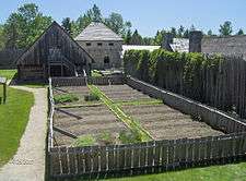
| John, Ontario and Queen Street Heritage Conservation District |
John, Ontario and Queen Street Heritage Conservation District, Port Hope, ON |
43°57′04″N 78°17′35″W / 43.9512°N 78.2931°W / 43.9512; -78.2931 (John, Ontario and Queen Street Heritage Conservation District) |
|
|
10001 |
|
|
| John Tucker Williams House: Penryn Homestead |
82 Victoria Street South, Port Hope, ON |
43°56′46″N 78°18′21″W / 43.9461°N 78.3058°W / 43.9461; -78.3058 (John Tucker Williams House: Penryn Homestead) |
|
|
9999 |
|
|
| Joseph Clarke House |
13 King Street, Port Hope, ON |
43°57′12″N 78°17′25″W / 43.9534°N 78.2904°W / 43.9534; -78.2904 (Joseph Clarke House) |
|
|
10007 |
|
 |
| Judson A. Brown House |
82 Augusta Street, Port Hope, ON |
43°56′58″N 78°17′52″W / 43.9494°N 78.2979°W / 43.9494; -78.2979 (Judson A. Brown House) |
|
|
10008 |
|
 |
| Little Bluestone |
117 King Street, Port Hope, ON |
43°56′50″N 78°17′24″W / 43.9473°N 78.29°W / 43.9473; -78.29 (Little Bluestone) |
|
|
8318 |
|
More images |
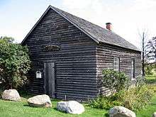
| Little Station |
10 Hayward Street, Port Hope, ON |
43°56′45″N 78°17′42″W / 43.9459°N 78.2949°W / 43.9459; -78.2949 (Little Station) |
|
|
10009 |
|
|
| Margaret and Charles Stuart House |
180 Dorset Street East, Port Hope, ON |
43°57′13″N 78°16′32″W / 43.9535°N 78.2755°W / 43.9535; -78.2755 (Margaret and Charles Stuart House) |
|
|
15583 |
|
 |
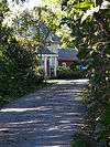
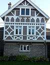
| Penstowe |
98 Ontario Street, Port Hope, ON |
43°57′22″N 78°17′34″W / 43.9561°N 78.2928°W / 43.9561; -78.2928 (Penstowe) |
|
|
8342 |
|

More images |
| Pinehurst |
44 Pine Street North, Port Hope, ON |
43°57′15″N 78°17′56″W / 43.9542°N 78.2990°W / 43.9542; -78.2990 (Pinehurst) |
|
|
10010 |
|
|
| Port Hope Capitol Theatre |
14 Queen Street, Port Hope, ON |
43°57′02″N 78°17′35″W / 43.9506°N 78.2931°W / 43.9506; -78.2931 (Port Hope Capitol Theatre) |
|
|
7788 |
|

More images |
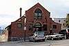
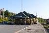
| Port Hope CNR Station |
20 Hayward Street, Port Hope, ON |
43°56′39″N 78°17′52″W / 43.9442°N 78.2979°W / 43.9442; -78.2979 (Port Hope CNR Station) |
4553 |
8898 |
|
|

More images |
| Port Hope Registry Office |
17 Mill Street North, Port Hope, ON |
43°57′04″N 78°17′31″W / 43.9512°N 78.2919°W / 43.9512; -78.2919 (Port Hope Registry Office) |
|
|
10011 |
|

More images |
| Port Hope Town Hall |
56 Queen Street, Port Hope, ON |
43°56′57″N 78°17′35″W / 43.9491°N 78.293°W / 43.9491; -78.293 (Port Hope Town Hall) |
|
|
10012 |
|

More images |
| Richard Trick Cottage |
254 Ridout Street, Port Hope, ON |
43°57′05″N 78°18′15″W / 43.9515°N 78.3043°W / 43.9515; -78.3043 (Richard Trick Cottage) |
|
|
10013 |
|
 |
| Robert Mitchell House |
8 King Street, Port Hope, ON |
43°57′13″N 78°17′27″W / 43.9537°N 78.2907°W / 43.9537; -78.2907 (Robert Mitchell House) |
|
|
10014 |
|

More images |
| Robert Youdan Terrace |
46 Baldwin Street, Port Hope, ON |
43°57′12″N 78°18′05″W / 43.9532°N 78.3014°W / 43.9532; -78.3014 (Robert Youdan Terrace) |
|
|
10015 |
|
|
| St. Lawrence Hall Block |
87 Walton Street, Port Hope, ON |
43°57′06″N 78°17′41″W / 43.9516°N 78.2948°W / 43.9516; -78.2948 (St. Lawrence Hall Block) |
|
8274 |
|
|
More images |
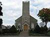
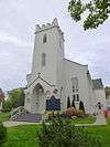
| St. Mark's Anglican Church |
51 King Street, Port Hope, ON |
43°57′05″N 78°17′25″W / 43.9515°N 78.2904°W / 43.9515; -78.2904 (St. Mark's Anglican Church) |
|
|
9964 |
|
More images |
| Smith Cottage |
72 Augusta Street, Port Hope, ON |
43°56′58″N 78°17′50″W / 43.9495°N 78.2973°W / 43.9495; -78.2973 (Smith Cottage) |
|
|
9961 |
|

More images |
| Smith House |
92 King Street, Port Hope, ON |
43°56′56″N 78°17′25″W / 43.9489°N 78.2902°W / 43.9489; -78.2902 (Smith House) |
|
|
9962 |
|
|
| Thomas B. Chalk House |
48 Bloomsgrove Avenue, Port Hope, ON |
43°57′26″N 78°17′29″W / 43.9572°N 78.2915°W / 43.9572; -78.2915 (Thomas B. Chalk House) |
|
|
9966 |
|
|
| Thomas Clarke House: The Cone |
115 Dorset Street West, Port Hope, ON |
43°56′50″N 78°17′58″W / 43.9473°N 78.2995°W / 43.9473; -78.2995 (Thomas Clarke House: The Cone) |
|
|
9967 |
|
More images |
| Thomas McCreery House |
78 Augusta Street, Port Hope, ON |
43°56′58″N 78°17′52″W / 43.9494°N 78.2977°W / 43.9494; -78.2977 (Thomas McCreery House) |
|
|
9968 |
|

More images |
| Thomas White House |
22 Shortt Street, Port Hope, ON |
43°56′59″N 78°18′42″W / 43.9497°N 78.3116°W / 43.9497; -78.3116 (Thomas White House) |
|
|
9969 |
|
|
| Turner House |
73 Mill Street South, Port Hope, ON |
43°56′52″N 78°17′29″W / 43.9478°N 78.2914°W / 43.9478; -78.2914 (Turner House) |
|
|
9971 |
|
|
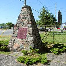
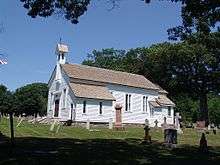
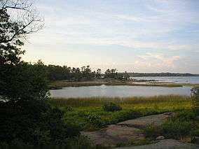
| Union Cemetery Chapel |
114 Toronto Road, Port Hope, ON |
43°57′21″N 78°19′01″W / 43.9559°N 78.317°W / 43.9559; -78.317 (Union Cemetery Chapel) |
|
|
8317 |
|
|
| Waddell Block |
1 Waddell Street, Port Hope, ON |
43°57′02″N 78°17′31″W / 43.9505°N 78.2919°W / 43.9505; -78.2919 (Waddell Block) |
|
|
9973 |
|
|
| Walton Street Heritage Conservation District, Downtown Port Hope |
Walton Street, between Pine Street and Mill Street, Port Hope, ON |
43°57′02″N 78°17′31″W / 43.9505°N 78.2919°W / 43.9505; -78.2919 (Walton Street Heritage Conservation District, Downtown Port Hope) |
|
|
7792 |
|
|
| William B. Cawthorne House |
64 Augusta Street, Port Hope, ON |
43°56′59″N 78°17′48″W / 43.9496°N 78.2968°W / 43.9496; -78.2968 (William B. Cawthorne House) |
|
|
9974 |
|

More images |
| William Bellamy Cottage |
64 Charles Street, Port Hope, ON |
43°57′09″N 78°18′18″W / 43.9525°N 78.3051°W / 43.9525; -78.3051 (William Bellamy Cottage) |
|
|
9975 |
|
|
| William Craig House |
42 Bedford Street, Port Hope, ON |
43°57′22″N 78°17′58″W / 43.956°N 78.2995°W / 43.956; -78.2995 (William Craig House) |
|
|
9976 |
|
|
| William Sisson House: Wimbourne |
89 Dorset Street West, Port Hope, ON |
43°56′52″N 78°17′52″W / 43.9477°N 78.2979°W / 43.9477; -78.2979 (William Sisson House: Wimbourne) |
|
|
9972 |
|

More images |
| William Skitch Cottage |
159 Bruton Street, Port Hope, ON |
43°57′10″N 78°18′31″W / 43.9528°N 78.3086°W / 43.9528; -78.3086 (William Skitch Cottage) |
|
|
9977 |
|
|
| William Trick Cottage |
9 Church Street, Port Hope, ON |
43°57′08″N 78°18′07″W / 43.9523°N 78.302°W / 43.9523; -78.302 (William Trick Cottage) |
|
|
9978 |
|
|


.JPG)