| Name |
Address |
Coordinates |
IDF |
IDP |
IDM |
 |
Image |
|---|
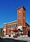
| Armoury |
89 Mosley Street, Aurora, ON |
43°59′56″N 79°27′43″W / 43.9989°N 79.4619°W / 43.9989; -79.4619 (Armoury) |
7519 |
|
|
|

More images |
| Aurora Post Office |
15213 Yonge Street, Aurora, ON |
43°59′56″N 79°28′02″W / 43.9989°N 79.4671°W / 43.9989; -79.4671 (Aurora Post Office) |
|
|
7299 |
|
More images |
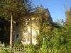
| Ballymore Farmhouse |
26 Hadley Court, Aurora, ON |
44°01′30″N 79°26′59″W / 44.025°N 79.4496°W / 44.025; -79.4496 (Ballymore Farmhouse) |
|
|
8914 |
|
 |
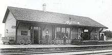
| Canadian National Railway Station |
135 Wellington Street, Aurora, ON |
44°00′03″N 79°27′35″W / 44.0008°N 79.4597°W / 44.0008; -79.4597 (Canadian National Railway Station) |
6500 |
|
|
|
|
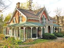
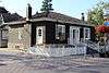
| The Carpenter's House |
69 Wellington Street East, Aurora, ON |
44°00′02″N 79°27′49″W / 44.0005°N 79.4635°W / 44.0005; -79.4635 (The Carpenter's House) |
|
|
6406 |
|

More images |
| Church Street School |
22 Church Street, Aurora, ON |
43°59′50″N 79°27′56″W / 43.9973°N 79.4655°W / 43.9973; -79.4655 (Church Street School) |
|
10401 |
6379 |
|

More images |
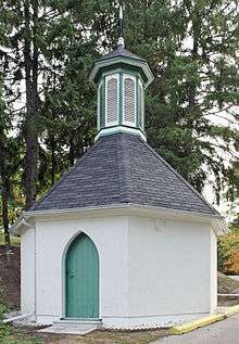
| The Dead House |
14253 Yonge Street, Aurora, ON |
43°58′36″N 79°27′40″W / 43.9766°N 79.461°W / 43.9766; -79.461 (The Dead House) |
|
|
8931 |
|
More images |
| Elmwood Lodge |
15032 Yonge Street, Aurora, ON |
43°59′39″N 79°28′00″W / 43.9943°N 79.4666°W / 43.9943; -79.4666 (Elmwood Lodge) |
|
|
9031 |
|
|
| Enos Lundy House |
938 St. John's Sideroad, Aurora, ON |
44°01′31″N 79°26′41″W / 44.0253°N 79.4448°W / 44.0253; -79.4448 (Enos Lundy House) |
|
|
8927 |
|
|
| Hartman's Corners Schoolhouse |
118 Wellington Street, Aurora, ON |
44°00′05″N 79°27′39″W / 44.0013°N 79.4609°W / 44.0013; -79.4609 (Hartman's Corners Schoolhouse) |
|
|
8928 |
|

More images |
| Hillary House |
15372 Yonge Street, Aurora, ON |
44°00′10″N 79°28′07″W / 44.0028°N 79.4687°W / 44.0028; -79.4687 (Hillary House) |
11951 |
|
8826 |
|
More images |
| Horton Place |
15342 Yonge Street, Aurora, ON |
44°00′07″N 79°28′07″W / 44.002°N 79.4685°W / 44.002; -79.4685 (Horton Place) |
|
|
8661 |
|

More images |
| The Keeper's House |
14253 Yonge Street, Aurora, ON |
43°58′35″N 79°27′42″W / 43.9765°N 79.4618°W / 43.9765; -79.4618 (The Keeper's House) |
|
|
8932 |
|
More images |
| Morrison House |
74 Wellington Street East, Aurora, ON |
44°00′02″N 79°27′48″W / 44.0006°N 79.4634°W / 44.0006; -79.4634 (Morrison House) |
|
|
8917 |
|
|
| Northeast Old Aurora Heritage Conservation District |
, Aurora, ON |
44°00′08″N 79°27′55″W / 44.0023°N 79.4654°W / 44.0023; -79.4654 (Northeast Old Aurora Heritage Conservation District) |
|
|
8929 |
|
 |
| The Pugh House |
106 Wells Street, Aurora, ON |
43°59′45″N 79°27′46″W / 43.9958°N 79.4628°W / 43.9958; -79.4628 (The Pugh House) |
|
|
8916 |
|
|
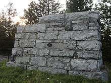
| Aurora Radial Railway Bridge Abutment |
520 Industrial Parkway South, Aurora, ON |
43°58′56″N 79°27′43″W / 43.9822°N 79.462°W / 43.9822; -79.462 (Aurora Radial Railway Bridge Abutment) |
|
|
8930 |
|
More images |
| The Red House |
16003 Yonge Street, Aurora, ON |
44°01′02″N 79°28′13″W / 44.0172°N 79.4703°W / 44.0172; -79.4703 (The Red House) |
|
|
8933 |
|
|
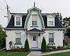
| The Roderick and Ethel Smith House |
88 Wells Street, Aurora, ON |
43°59′48″N 79°27′47″W / 43.9967°N 79.4631°W / 43.9967; -79.4631 (The Roderick and Ethel Smith House) |
|
|
8934 |
|

More images |
| W. Lewis Stephens House |
97 Wells Street, Aurora, ON |
43°59′47″N 79°27′45″W / 43.9965°N 79.4625°W / 43.9965; -79.4625 (W. Lewis Stephens House) |
|
|
18580 |
|

More images |
| The Walter Grice House |
89 Wells Street, Aurora, ON |
43°59′48″N 79°27′45″W / 43.9967°N 79.4626°W / 43.9967; -79.4626 (The Walter Grice House) |
|
|
8915 |
|

More images |
| Willow Farm |
15900 Yonge Street, Aurora, ON |
44°00′57″N 79°28′23″W / 44.0158°N 79.473°W / 44.0158; -79.473 (Willow Farm) |
|
|
8919 |
|
|
| Wilton Barn |
13831 Leslie Street, Aurora, ON |
43°58′33″N 79°24′35″W / 43.9759°N 79.4096°W / 43.9759; -79.4096 (Wilton Barn) |
|
|
8918 |
|

More images |
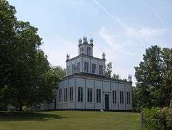
| Sharon Temple National Historic Site of Canada |
18974 Leslie Street, East Gwillimbury (Sharon), ON |
44°06′04″N 79°26′29″W / 44.1012°N 79.4413°W / 44.1012; -79.4413 (Sharon Temple National Historic Site of Canada) |
10712 |
10571 |
|
|
More images |
| The Briars - Manor House |
55 Hedge Road, Georgina, ON |
44°19′18″N 79°21′42″W / 44.3218°N 79.3616°W / 44.3218; -79.3616 (The Briars - Manor House) |
|
5605 |
|
|

More images |
| The Briars - Peacock House |
55 Hedge Road, Georgina, ON |
44°19′16″N 79°21′44″W / 44.3211°N 79.3622°W / 44.3211; -79.3622 (The Briars - Peacock House) |
|
7604 |
|
|

More images |
| Former Canadian National Railway Station |
30 Station Street, Maple, ON |
43°51′34″N 79°30′25″W / 43.8594°N 79.5069°W / 43.8594; -79.5069 (Former Canadian National Railway Station) |
6765 |
|
|
|
|
| Adam Clendenen House |
8 Green Hollow, Markham, ON |
43°54′12″N 79°14′31″W / 43.9032°N 79.242°W / 43.9032; -79.242 (Adam Clendenen House) |
|
|
8383 |
|

More images |
| Buttonville Women's Institute Community Hall |
8931 Woodbine Avenue, Markham, ON |
43°51′38″N 79°21′39″W / 43.8605°N 79.3608°W / 43.8605; -79.3608 (Buttonville Women's Institute Community Hall) |
|
|
15536 |
|

More images |
| Canadian National Railway Station |
7 Station Lane, Markham, ON |
43°51′52″N 79°18′40″W / 43.8645°N 79.3112°W / 43.8645; -79.3112 (Canadian National Railway Station) |
6808 |
|
|
|
|
| Eckhardt-McKay House |
197 Main Street, Markham, ON |
43°52′06″N 79°18′44″W / 43.8683°N 79.3121°W / 43.8683; -79.3121 (Eckhardt-McKay House) |
|
|
15234 |
|
 |
| Edey House |
4 Leahill, Markham, ON |
43°48′56″N 79°24′57″W / 43.8156°N 79.4159°W / 43.8156; -79.4159 (Edey House) |
|
|
15238 |
|
|
| The Edward Pease House |
8965 Woodbine, Markham, ON |
43°51′40″N 79°21′39″W / 43.8611°N 79.3609°W / 43.8611; -79.3609 (The Edward Pease House) |
|
|
15374 |
|

More images |
| Evangelical Lutheran Church Parsonage |
109 Main, Markham, ON |
43°51′46″N 79°18′36″W / 43.8629°N 79.3099°W / 43.8629; -79.3099 (Evangelical Lutheran Church Parsonage) |
|
|
15239 |
|
 |
| Former Canadian National Railway Station |
214 Main Street North, Markham, ON |
43°52′59″N 79°15′43″W / 43.883°N 79.262°W / 43.883; -79.262 (Former Canadian National Railway Station) |
6762 |
|
|
|
More images |
| German Mills Community Centre |
80 German Mills, Markham, ON |
43°49′13″N 79°22′18″W / 43.8202°N 79.3716°W / 43.8202; -79.3716 (German Mills Community Centre) |
|
|
15249 |
|

More images |
| John Lane House |
111 John, Markham, ON |
43°48′55″N 79°24′50″W / 43.8154°N 79.4138°W / 43.8154; -79.4138 (John Lane House) |
|
|
15248 |
|
|
| Markham Village Heritage Conservation District |
Vinegar Hill, Markham Village, and Mount Joy, straddling Main Street, Markham, ON |
43°52′59″N 79°15′43″W / 43.8831°N 79.262°W / 43.8831; -79.262 (Markham Village Heritage Conservation District) |
|
|
15250 |
|
|
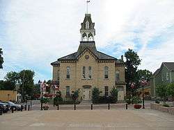
| Old Town Hall |
96 Main Street North, Markham, ON |
43°52′39″N 79°15′39″W / 43.8775°N 79.2607°W / 43.8775; -79.2607 (Old Town Hall) |
|
|
15343 |
|
|
| St. John's Lutheran Cemetery |
8933 Woodbine, Markham, ON |
43°51′36″N 79°21′38″W / 43.8601°N 79.3606°W / 43.8601; -79.3606 (St. John's Lutheran Cemetery) |
|
|
15363 |
|

More images |
| The Stiver House |
206 Main, Markham, ON |
43°52′07″N 79°18′45″W / 43.8686°N 79.3124°W / 43.8686; -79.3124 (The Stiver House) |
|
|
15392 |
|
 |
| Thornhill Village Library |
10 Colborne, Markham, ON |
43°48′56″N 79°25′24″W / 43.8156°N 79.4234°W / 43.8156; -79.4234 (Thornhill Village Library) |
|
|
15394 |
|
|
| Village of Markham Post Office |
53 Main, Markham, ON |
43°52′15″N 79°15′32″W / 43.8708°N 79.259°W / 43.8708; -79.259 (Village of Markham Post Office) |
|
|
15412 |
|
 |
| Wales House |
159 Main, Markham, ON |
43°52′50″N 79°15′41″W / 43.8806°N 79.2614°W / 43.8806; -79.2614 (Wales House) |
|
|
15416 |
|
 |
| The Wedding Cake House |
48 Main, Markham, ON |
43°52′35″N 79°15′37″W / 43.8765°N 79.2604°W / 43.8765; -79.2604 (The Wedding Cake House) |
|
|
15393 |
|
 |
| William Eckardt House |
124 Main, Markham, ON |
43°51′48″N 79°18′37″W / 43.8634°N 79.3103°W / 43.8634; -79.3103 (William Eckardt House) |
|
|
15417 |
|
 |
| William Lane Cooper House |
14 Colborne, Markham, ON |
43°48′56″N 79°25′23″W / 43.8156°N 79.423°W / 43.8156; -79.423 (William Lane Cooper House) |
|
|
15443 |
|
|
| Brooks Howard House |
365 Main Street, Newmarket, ON |
44°04′24″N 79°27′32″W / 44.0732°N 79.4589°W / 44.0732; -79.4589 (Brooks Howard House) |
|
|
15237 |
|
 |
| Brooks Howard Millard House |
310 Eagle, Newmarket, ON |
44°02′55″N 79°27′50″W / 44.0486°N 79.464°W / 44.0486; -79.464 (Brooks Howard Millard House) |
|
|
14946 |
|
 |
| Christian Baptist Church |
135 Main Street South, Newmarket, ON |
44°03′21″N 79°27′33″W / 44.0559°N 79.4592°W / 44.0559; -79.4592 (Christian Baptist Church) |
|
|
16004 |
|
 |
| Former Canadian National Railway Station |
450 Davis Drive, Newmarket, ON |
44°03′33″N 79°27′32″W / 44.0591°N 79.4590°W / 44.0591; -79.4590 (Former Canadian National Railway Station) |
6763 |
9225 |
|
|
|
| Hicksite Friends Burying Ground |
16580 Yonge Street, Newmarket, ON |
44°01′56″N 79°28′30″W / 44.0323°N 79.475°W / 44.0323; -79.475 (Hicksite Friends Burying Ground) |
|
|
6355 |
|
|
| Hollingshead House |
449 Eagle, Newmarket, ON |
44°03′00″N 79°27′27″W / 44.05°N 79.4576°W / 44.05; -79.4576 (Hollingshead House) |
|
|
14853 |
|
 |
| Isaac Silver House |
220 Prospect Street, Newmarket, ON |
44°03′10″N 79°27′11″W / 44.0527°N 79.4531°W / 44.0527; -79.4531 (Isaac Silver House) |
|
|
9806 |
|
|
| John Bogart House |
16860 Leslie Street, Newmarket, ON |
44°02′59″N 79°25′40″W / 44.0498°N 79.4278°W / 44.0498; -79.4278 (John Bogart House) |
|
|
18599 |
|
 |
| John Millard House |
367 Botsford Street, Newmarket, ON |
44°03′08″N 79°27′44″W / 44.05211°N 79.46213°W / 44.05211; -79.46213 (John Millard House) |
|
|
|
|
|
| King George Public School |
400 Park Ave., Newmarket, ON |
44°03′12″N 79°27′39″W / 44.0532°N 79.4607°W / 44.0532; -79.4607 (King George Public School) |
|
|
8571 |
|

More images |
| Levi Rogers House |
170 Lorne Avenue, Newmarket, ON |
44°03′08″N 79°27′50″W / 44.0522°N 79.464°W / 44.0522; -79.464 (Levi Rogers House) |
|
|
9928 |
|

More images |
| Main Street Newmarket Heritage Conservation District |
Main Street South, Newmarket, ON |
44°03′05″N 79°27′22″W / 44.0514°N 79.456°W / 44.0514; -79.456 (Main Street Newmarket Heritage Conservation District) |
|
|
15250 |
|
 |
| Mary Ann Wilken House |
588 Gorham Street, Newmarket, ON |
44°03′06″N 79°27′05″W / 44.0518°N 79.4513°W / 44.0518; -79.4513 (Mary Ann Wilken House) |
|
|
11750 |
|
|
| The Newmarket Federal Building |
180 Main, Newmarket, ON |
44°03′14″N 79°27′28″W / 44.0538°N 79.4577°W / 44.0538; -79.4577 (The Newmarket Federal Building) |
|
|
14442 |
|
 |
| Old Town Hall |
460 Botsford Street, Newmarket, ON |
44°03′10″N 79°27′30″W / 44.0529°N 79.4584°W / 44.0529; -79.4584 (Old Town Hall) |
|
|
6381 |
|
More images |
| Pioneer Burying Ground |
Eagle Street, Newmarket, ON |
44°02′54″N 79°27′55″W / 44.0483°N 79.4653°W / 44.0483; -79.4653 (Pioneer Burying Ground) |
|
|
7571 |
|

More images |
| The Radial Arch |
Queen Street, Newmarket, ON |
44°03′26″N 79°27′22″W / 44.0573°N 79.4561°W / 44.0573; -79.4561 (The Radial Arch) |
|
|
15202 |
|
More images |
| Registry Office, North York |
134 Main Street South, Newmarket, ON |
44°03′18″N 79°27′30″W / 44.0549°N 79.4584°W / 44.0549; -79.4584 (Registry Office, North York) |
|
|
6382 |
|

More images |
| Saint Paul's Anglican Church and Rectory |
227 Church Street, Newmarket, ON |
44°03′05″N 79°27′32″W / 44.0515°N 79.459°W / 44.0515; -79.459 (Saint Paul's Anglican Church and Rectory) |
|
|
15464 |
|
 |
| Schmidt House |
324 Millard Avenue, Newmarket, ON |
44°03′12″N 79°27′52″W / 44.0534°N 79.4645°W / 44.0534; -79.4645 (Schmidt House) |
|
|
8528 |
|

More images |
| Stickwood Brickyard and Wetlands |
642 Srigley, Newmarket, ON |
44°03′21″N 79°27′01″W / 44.0558°N 79.4502°W / 44.0558; -79.4502 (Stickwood Brickyard and Wetlands) |
|
|
14852 |
|
|
| Stuart Scott Public School |
247 Lorne Avenue, Newmarket, ON |
44°02′59″N 79°27′48″W / 44.0497°N 79.4632°W / 44.0497; -79.4632 (Stuart Scott Public School) |
|
|
8552 |
|

More images |
| Thomas Dales House |
182 Church Street, Newmarket, ON |
44°03′10″N 79°27′35″W / 44.0528°N 79.4596°W / 44.0528; -79.4596 (Thomas Dales House) |
|
|
9231 |
|

More images |
| William Stickwood House |
896 Mulock Drive, Newmarket, ON |
44°02′43″N 79°26′15″W / 44.0452°N 79.4374°W / 44.0452; -79.4374 (William Stickwood House) |
|
|
8566 |
|
|