| Name |
Address |
Coordinates |
IDF |
IDP |
IDM |
 |
Image |
|---|
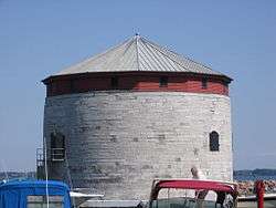
| Branch Tower East |
Fort Henry Defense Complex, Kingston, ON |
44°14′N 76°28′W / 44.23°N 76.46°W / 44.23; -76.46 (Branch Tower East) |
4357 |
|
|
|

More images |
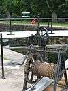
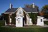
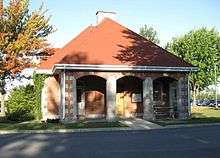
| Defensible Lockmaster's House |
Rideau Canal National Historic Site of Canada, Kingston, ON |
44°14′52″N 76°11′17″W / 44.2479°N 76.188°W / 44.2479; -76.188 (Defensible Lockmaster's House (Upper Brewers Lock)) |
16781 |
|
|
|
 |
| Defensible Lockmaster's House |
Rideau Canal National Historic Site of Canada, Kingston, ON |
44°33′48″N 76°17′29″W / 44.5634°N 76.2914°W / 44.5634; -76.2914 (Defensible Lockmaster's House (Davis Lock)) |
16782 |
|
|
|
 |
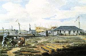
| Kingston Harbour, Shoal Martello Tower |
In Kingston Harbour, Kingston, ON |
44°13′44″N 76°28′41″W / 44.2289°N 76.4781°W / 44.2289; -76.4781 (Kingston Harbour, Shoal Martello Tower) |
4737 |
|
|
|
|
| Lower Brewers Defensible Lockmaster's House |
Rideau Canal National Historic Site of Canada, Kingston (Washburn), ON |
44°23′20″N 76°19′30″W / 44.389°N 76.325°W / 44.389; -76.325 (Lower Brewers Defensible Lockmaster's House) |
11024 |
|
|
|
 |
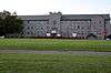
| Vimy Barracks Building B7 |
1 Estafette Street, Vimy Barracks, CFB Kingston, ON |
44°14′24″N 76°26′13″W / 44.24°N 76.437°W / 44.24; -76.437 (Vimy Barracks Building B7) |
2883 |
|
|
|
|
| 1 Baiden Street |
1 Baiden Street, Kingston, ON |
44°13′18″N 76°31′09″W / 44.2217°N 76.5191°W / 44.2217; -76.5191 (1 Baiden Street) |
|
|
9664 |
|
|
| 157-161 Queen Street |
157 Queen Street, Kingston, ON |
44°13′59″N 76°29′08″W / 44.2331°N 76.4856°W / 44.2331; -76.4856 (157-161 Queen Street) |
|
|
9734 |
|
|
| 223 King Street East, Kingston |
223 King Street East, Kingston, ON |
44°13′39″N 76°29′01″W / 44.2275°N 76.4835°W / 44.2275; -76.4835 (223 King Street East, Kingston) |
|
8265 |
|
|

More images |
| 232 King Street East |
232 King Street East, Kingston, ON |
44°13′40″N 76°29′00″W / 44.2277°N 76.4834°W / 44.2277; -76.4834 (232 King Street East) |
|
|
15961 |
|

More images |
| 610 Montreal Street |
610 Montreal Street, Kingston, ON |
44°14′54″N 76°29′12″W / 44.2484°N 76.4867°W / 44.2484; -76.4867 (610 Montreal Street) |
|
|
14101 |
|
|
| 9 North Street |
9 North Street, Kingston, ON |
44°14′15″N 76°28′53″W / 44.2376°N 76.4815°W / 44.2376; -76.4815 (9 North Street) |
|
|
15958 |
|
|
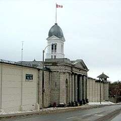
| Administration Building /Cell Block (C-18, C-16) |
Former Women's Prison, Kingston, ON |
44°13′43″N 76°33′21″W / 44.2285°N 76.5557°W / 44.2285; -76.5557 (Administration Building /Cell Block (C-18, C-16)) |
7584 |
|
|
|
 |
| Anglican Diocesan Centre |
90 Johnson Street, Kingston, ON |
44°13′46″N 76°29′02″W / 44.2295°N 76.4838°W / 44.2295; -76.4838 (Anglican Diocesan Centre) |
|
|
10768 |
|

More images |
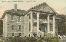
| Ann Baillie Building National Historic Site of Canada |
Kingston General Hospital Complex, Kingston, ON |
44°13′26″N 76°29′30″W / 44.2239°N 76.4918°W / 44.2239; -76.4918 (Ann Baillie Building National Historic Site of Canada) |
4024 |
|
|
|
More images |
| Armoury |
100 Montreal Street, Kingston, ON |
44°14′02″N 76°29′02″W / 44.234°N 76.484°W / 44.234; -76.484 (Armoury) |
3301 |
|
|
|
|
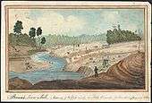
| Barriefield Heritage Conservation District |
On a hillside rising from the eastern shore of the Great Cataraqui River, adjacent to the intersection of Highways 2 and 15 near Fort Henry, the Royal Military College and Canadian Forces Base Kingston, Kingston, ON |
44°14′26″N 76°27′42″W / 44.2405°N 76.4617°W / 44.2405; -76.4617 (Barriefield Heritage Conservation District) |
|
|
10829 |
|
|
| Bellevue House National Historic Site of Canada |
35 Centre Street, Kingston, ON |
44°13′22″N 76°30′12″W / 44.2229°N 76.5034°W / 44.2229; -76.5034 (Bellevue House National Historic Site of Canada) |
1284
4355 |
|
|
|
More images |
| Blockhouse |
Kingston Mills Lock, Kingston, ON |
44°17′34″N 76°26′34″W / 44.2927°N 76.4429°W / 44.2927; -76.4429 (Blockhouse) |
10653 |
|
|
|
|
| Bradstreet Block |
Tête de Pont barracks in Fort Frontenac, Kingston, ON |
44°14′03″N 76°28′41″W / 44.2341°N 76.478°W / 44.2341; -76.478 (Bradstreet Block) |
4330 |
|
|
|
|
| Branch Tower West |
Fort Henry, Kingston, ON |
44°14′N 76°28′W / 44.23°N 76.46°W / 44.23; -76.46 (Branch Tower West) |
4356 |
|
|
|

More images |
| Bridge Office and Shop |
adjacent to a lift bridge on the Lasalle Causeway of the Rideau Canal, Kingston, ON |
44°14′05″N 76°28′30″W / 44.2348°N 76.4751°W / 44.2348; -76.4751 (Bridge Office and Shop) |
10056 |
|
|
|
|
| Building B-37 |
CFB Kingston, Kingston, ON |
44°14′37″N 76°27′22″W / 44.2435°N 76.456°W / 44.2435; -76.456 (Building B-37) |
11324 |
|
|
|
|
| Building B-39 |
CFB Kingston, Kingston, ON |
44°14′44″N 76°27′20″W / 44.2455°N 76.4555°W / 44.2455; -76.4555 (Building B-39) |
11323 |
|
|
|
|
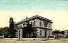
| Canadian National Railway Station |
810 Montreal Street, Kingston, ON |
44°15′14″N 76°29′06″W / 44.2538°N 76.4851°W / 44.2538; -76.4851 (Canadian National Railway Station) |
4629 |
|
|
|
|
| Caponier |
Fort Henry, Kingston, ON |
44°13′49″N 76°27′37″W / 44.2302°N 76.4604°W / 44.2302; -76.4604 (Caponier) |
4363 |
|
|
|

More images |
| Cataraqui Cemetery National Historic Site of Canada |
Cataraqui Cemetery, 927 Purdy’s Mill Road, Kingston, ON |
44°15′40″N 76°32′32″W / 44.2610°N 76.5423°W / 44.2610; -76.5423 (Cataraqui Cemetery National Historic Site of Canada) |
18925 |
|
|
|
|
| Cedar Island Cathcart Tower |
Cedar Island, Kingston, ON |
44°13′32″N 76°27′15″W / 44.2255°N 76.4543°W / 44.2255; -76.4543 (Cedar Island Cathcart Tower) |
10111 |
|
|
|

More images |
| Church of the Good Thief (Roman Catholic) |
743 King Street West, Kingston, ON |
44°13′14″N 76°31′21″W / 44.2205°N 76.5224°W / 44.2205; -76.5224 (Church of the Good Thief (Roman Catholic)) |
|
10402 |
|
|
_-_Kingston_Ontario_Canada_(2010-04-21).jpg)
More images |
| Collins Bay Institution, Administration Building, A-1 |
Federal Penitentiary at Collins Bay, Kingston, ON |
44°14′N 76°34′W / 44.23°N 76.56°W / 44.23; -76.56 (Collins Bay Institution, Administration Building, A-1) |
3296 |
|
|
|
More images |
| Collins Bay Institution, Cell Block, Building B-1 |
455 Bath Road, Collins Bay Institution, Kingston, ON |
44°14′N 76°34′W / 44.23°N 76.56°W / 44.23; -76.56 (Collins Bay Institution, Cell Block, Building B-1) |
2658 |
|
|
|
|
| Commissariat Stores / Reverse Fire Chamber East |
Fort Henry, Kingston, ON |
44°14′N 76°28′W / 44.23°N 76.46°W / 44.23; -76.46 (Commissariat Stores / Reverse Fire Chamber East) |
4362 |
|
|
|
|
| Commissariat Stores / Reverse Fire Chamber West |
Fort Henry Defence Complex, Kingston, ON |
44°14′N 76°28′W / 44.23°N 76.46°W / 44.23; -76.46 (Commissariat Stores / Reverse Fire Chamber West) |
4397 |
|
|
|
|
| Courcelles Block |
Tête de Pont barracks in Fort Frontenac, Kingston, ON |
44°14′03″N 76°28′41″W / 44.2341°N 76.478°W / 44.2341; -76.478 (Courcelles Block) |
4331 |
|
|
|
|
| Curtain Wall and Demi-Bastions |
Fort Henry, Kingston, ON |
44°14′N 76°28′W / 44.23°N 76.46°W / 44.23; -76.46 (Curtain Wall and Demi-Bastions) |
4359 |
|
|
|
|
| De Noyan Block |
Fort Frontenac, Kingston, ON |
44°14′02″N 76°28′41″W / 44.234°N 76.478°W / 44.234; -76.478 (De Noyan Block) |
3317 |
|
|
|
|
| East Workshop |
Kingston Penitentiary, Kingston, ON |
44°13′09″N 76°30′45″W / 44.2191°N 76.5126°W / 44.2191; -76.5126 (East Workshop) |
10242 |
|
|
|
|
| Elizabeth Cottage National Historic Site of Canada |
251 Brock Street, Kingston, ON |
44°13′54″N 76°29′21″W / 44.2318°N 76.4891°W / 44.2318; -76.4891 (Elizabeth Cottage National Historic Site of Canada) |
11909 |
|
|
|
 |
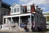
| Elmhirst House |
443 Union Street West, Kingston, ON |
44°13′27″N 76°30′41″W / 44.2241°N 76.5115°W / 44.2241; -76.5115 (Elmhirst House) |
19617 |
|
|
|
|
| Former Prison for Women |
Kingston Penitentiary, Building A3, Kingston, ON |
44°13′18″N 76°30′49″W / 44.2216°N 76.5136°W / 44.2216; -76.5136 (Former Prison for Women) |
10239 |
|
|
|
 |
| Former Warden's Residence |
555 King Street West, Kingston, ON |
44°13′18″N 76°30′49″W / 44.2216°N 76.5136°W / 44.2216; -76.5136 (Former Warden's Residence) |
10217 |
|
|
|

More images |
| Fort Champlain Cadet Quarters (B34) |
RMC Kingston, Kingston, ON |
44°13′59″N 76°27′58″W / 44.233°N 76.466°W / 44.233; -76.466 (Fort Champlain Cadet Quarters (B34)) |
2672 |
|
|
|
|
| Fort Frontenac National Historic Site of Canada |
1 Ontario Street, Kingston, ON |
44°14′01″N 76°28′41″W / 44.2336°N 76.478°W / 44.2336; -76.478 (Fort Frontenac National Historic Site of Canada) |
12130 |
|
|
|
More images |
| Fort Henry National Historic Site of Canada |
Point Henry between the mouth of Kingston harbour and a second natural harbour at the mouth of the Cataraqui River, Kingston, ON |
44°13′52″N 76°27′35″W / 44.231°N 76.4597°W / 44.231; -76.4597 (Fort Henry National Historic Site of Canada) |
7869 |
|
|
|

More images |
| Fort Lasalle Dormitory |
RMC Kingston, Kingston, ON |
44°14′00″N 76°28′00″W / 44.2333°N 76.4667°W / 44.2333; -76.4667 (Fort Lasalle Dormitory) |
4812 |
|
|
|
More images |
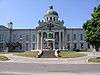
| Frontenac County Court House National Historic Site of Canada |
1 Court Street, Kingston, ON |
44°13′40″N 76°29′23″W / 44.2278°N 76.4896°W / 44.2278; -76.4896 (Frontenac County Court House National Historic Site of Canada) |
12033 |
8845 |
|
|
 |
| Registry Office |
1 Court Street, Kingston, ON |
44°13′38″N 76°29′27″W / 44.2272°N 76.4907°W / 44.2272; -76.4907 (Registry Office) |
|
|
10770 |
|
|
| Guardhouse No. 14 |
Point Frederick, RMC Kingston, Kingston, ON |
44°14′00″N 76°28′00″W / 44.2333°N 76.4667°W / 44.2333; -76.4667 (Guardhouse No. 14) |
4785 |
|
|
|
|
| Health Care Clinic (Building B-62) |
CFB Kingston, Kingston, ON |
44°14′50″N 76°27′35″W / 44.2473°N 76.4598°W / 44.2473; -76.4598 (Health Care Clinic (Building B-62)) |
2685 |
|
|
|
|
| Heating Plant, former Commissariat Storehouse |
Tête de Pont barracks in Fort Frontenac, Kingston, ON |
44°14′03″N 76°28′41″W / 44.2341°N 76.478°W / 44.2341; -76.478 (Heating Plant, former Commissariat Storehouse) |
4332 |
|
|
|
|
| Hewitt House |
RMC Kingston, Kingston, ON |
44°14′00″N 76°28′00″W / 44.2333°N 76.4667°W / 44.2333; -76.4667 (Hewitt House) |
4807 |
|
|
|
|
| Inglewood |
110 Collingwood Street, Kingston, ON |
44°13′31″N 76°30′04″W / 44.2253°N 76.5012°W / 44.2253; -76.5012 (Inglewood) |
|
|
15960 |
|

More images |
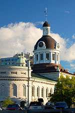
| Kingston City Hall National Historic Site of Canada |
216 Ontario Street, Kingston, ON |
44°13′48″N 76°28′49″W / 44.2299°N 76.4803°W / 44.2299; -76.4803 (Kingston City Hall National Historic Site of Canada) |
7628 |
|
|
|
More images |
| Custom House |
294 King Street East, Kingston, ON |
44°13′46″N 76°28′56″W / 44.2295°N 76.4821°W / 44.2295; -76.4821 (Custom House) |
3291 |
|
|
|
 |
| Kingston Customs House National Historic Site of Canada |
294 King Street East, Kingston, ON |
44°13′47″N 76°28′56″W / 44.2296°N 76.4821°W / 44.2296; -76.4821 (Kingston Customs House National Historic Site of Canada) |
7538 |
|
|
|
More images |
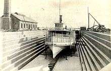
| Kingston Dry Dock National Historic Site of Canada |
55 Ontario Street, Kingston, ON |
44°13′34″N 76°29′02″W / 44.2261°N 76.4838°W / 44.2261; -76.4838 (Kingston Dry Dock National Historic Site of Canada) |
10531 |
|
|
|
More images |
| Kingston Drydock Pumphouse |
55 Ontario Street, Kingston, ON |
44°13′29″N 76°28′58″W / 44.2248°N 76.4829°W / 44.2248; -76.4829 (Kingston Drydock Pumphouse) |
4696 |
|
|
|

More images |
| Kingston Fortifications National Historic Site of Canada |
, Kingston, ON |
44°13′45″N 76°28′57″W / 44.2293°N 76.4825°W / 44.2293; -76.4825 (Kingston Fortifications National Historic Site of Canada) |
13858 |
|
|
|
|
| Kingston General Hospital National Historic Site of Canada |
76 Stuart Street, Kingston, ON |
44°13′28″N 76°29′34″W / 44.2244°N 76.4929°W / 44.2244; -76.4929 (Kingston General Hospital National Historic Site of Canada) |
4218 |
|
|
|
.jpg)
More images |
| Kingston Navy Yard National Historic Site of Canada |
Campus of the Royal Military College, Kingston, ON |
44°13′28″N 76°29′34″W / 44.2244°N 76.4929°W / 44.2244; -76.4929 (Kingston Navy Yard National Historic Site of Canada) |
10484 |
|
|
|
 |
| Kingston Penitentiary National Historic Site of Canada |
King Street West, Kingston, ON |
44°13′11″N 76°30′49″W / 44.2197°N 76.5136°W / 44.2197; -76.5136 (Kingston Penitentiary National Historic Site of Canada) |
13265 |
|
|
|
More images |
| LaSalle Block |
Fort Frontenac, Kingston, ON |
44°14′02″N 76°28′41″W / 44.234°N 76.478°W / 44.234; -76.478 (LaSalle Block) |
3318 |
|
|
|
|
| Lockmaster's House |
Kingston Mills Lock, Rideau Canal, Kingston, ON |
44°17′31″N 76°26′31″W / 44.292°N 76.442°W / 44.292; -76.442 (Lockmaster's House) |
11333 |
|
|
|
|
| Main Cellblock |
Kingston Penitentiary, Kingston, ON |
44°13′16″N 76°30′45″W / 44.2212°N 76.5125°W / 44.2212; -76.5125 (Main Cellblock) |
3309 |
|
|
|
|
| Market Square Heritage Conservation District |
roughly bounded by King, Clarence, Brock, and Ontario Streets, Kingston, ON |
44°13′47″N 76°28′49″W / 44.2297°N 76.4804°W / 44.2297; -76.4804 (Market Square Heritage Conservation District) |
|
|
7430 |
|
|
| Murney Martello Tower |
18 King Street West, Kingston, ON |
44°13′20″N 76°29′26″W / 44.2223°N 76.4905°W / 44.2223; -76.4905 (Murney Martello Tower) |
10810 |
|
|
|
.jpg) |
| Murney Tower National Historic Site of Canada |
18 King Street West, Kingston, ON |
44°13′21″N 76°29′26″W / 44.2224°N 76.4905°W / 44.2224; -76.4905 (Murney Tower National Historic Site of Canada) |
7640 |
|
|
|
|
| North Lodge |
555 King Street (Kingston Penitentiary), Kingston, ON |
44°13′08″N 76°30′47″W / 44.219°N 76.513°W / 44.219; -76.513 (North Lodge) |
3656 |
|
|
|
|
| Northeast Tower Building D-1 |
Collins Bay Institution, Kingston, ON |
44°14′N 76°34′W / 44.23°N 76.56°W / 44.23; -76.56 (Northeast Tower Building D-1) |
2761 |
|
|
|
|
| Northwest Tower Building D-4 |
Collins Bay Institution, Kingston, ON |
44°14′N 76°34′W / 44.23°N 76.56°W / 44.23; -76.56 (Northwest Tower Building D-4) |
2800 |
|
|
|
|
| Old Fort Henry, Reverse Fire Gallery West |
Fort Henry, Kingston, ON |
44°13′49″N 76°27′37″W / 44.2302°N 76.4604°W / 44.2302; -76.4604 (Old Fort Henry, Reverse Fire Gallery West) |
4350 |
|
|
|
.jpg) |
| Old Kingston Post Office National Historic Site of Canada |
86 Clarence Street, Kingston, ON |
44°13′48″N 76°29′00″W / 44.23°N 76.4832°W / 44.23; -76.4832 (Old Kingston Post Office National Historic Site of Canada) |
11661 |
|
|
|
.jpg)
More images |
| Penitentiary Towers |
Kingston Penitentiary, Kingston, ON |
44°13′08″N 76°30′47″W / 44.219°N 76.513°W / 44.219; -76.513 (Penitentiary Towers) |
16724 |
|
|
|
|
| Point Frederick Buildings National Historic Site of Canada |
Point Frederick, RMC Kingston, Kingston, ON |
44°13′40″N 76°28′10″W / 44.2277°N 76.4695°W / 44.2277; -76.4695 (Point Frederick Buildings National Historic Site of Canada) |
11616 |
|
|
|

More images |
| Portsmouth Community Correctional Centre |
508 Portsmouth Avenue, Kingston, ON |
44°14′15″N 76°31′44″W / 44.2375°N 76.5288°W / 44.2375; -76.5288 (Portsmouth Community Correctional Centre) |
9769 |
|
|
|

More images |
| First Baptist Church |
110 Sydenham Street, Kingston, ON |
44°13′51″N 76°29′16″W / 44.2308°N 76.4877°W / 44.2308; -76.4877 (First Baptist Church) |
|
|
15959 |
|
|
| Light Tower |
Pigeon Island, southwest of Wolfe Island, Kingston, ON |
44°04′00″N 76°33′00″W / 44.0667°N 76.5499°W / 44.0667; -76.5499 (Light Tower) |
13343 |
|
|
|
|
| Post Office (Old) |
86 Clarence Street, Kingston, ON |
44°13′47″N 76°28′56″W / 44.2296°N 76.4823°W / 44.2296; -76.4823 (Post Office (Old)) |
16442 |
|
|
|
|
| Prince George Hotel |
200 Ontario Street, Kingston, ON |
44°13′45″N 76°28′51″W / 44.2293°N 76.4808°W / 44.2293; -76.4808 (Prince George Hotel) |
|
1503 |
|
|
|
| Redoubt |
Fort Henry, Kingston, ON |
44°14′N 76°28′W / 44.23°N 76.46°W / 44.23; -76.46 (Redoubt) |
4354 |
|
|
|
|
| Reverse Fire Gallery East |
Fort Henry, Kingston, ON |
44°13′49″N 76°27′37″W / 44.2302°N 76.4604°W / 44.2302; -76.4604 (Reverse Fire Gallery East) |
4352 |
|
|
|
|
| Rideau Canal National Historic Site of Canada |
Rideau Street, from Kingston to Ottawa, ON |
44°40′45″N 76°13′16″W / 44.6793°N 76.2212°W / 44.6793; -76.2212 (Rideau Canal National Historic Site of Canada) |
5727 |
|
|
|
More images |
| RMC Buildings: Gatehouse #3 |
Point Frederick, RMC Kingston, Kingston, ON |
44°14′00″N 76°28′00″W / 44.2333°N 76.4667°W / 44.2333; -76.4667 (RMC Buildings: Gatehouse #3) |
4784 |
|
|
|
|
| Rochleau Property |
68 Princess Street, Kingston, ON |
44°13′53″N 76°28′53″W / 44.2313°N 76.4814°W / 44.2313; -76.4814 (Rochleau Property) |
|
8899 |
|
|
|
| Ross Block |
Tête de Pont barracks in Fort Frontenac, Kingston, ON |
44°14′03″N 76°28′41″W / 44.2341°N 76.478°W / 44.2341; -76.478 (Ross Block) |
4335 |
|
|
|
|
| Royal Military College of Canada Building 2 |
RMC Kingston, Kingston, ON |
44°14′06″N 76°28′13″W / 44.235°N 76.4702°W / 44.235; -76.4702 (Royal Military College of Canada Building 2) |
11224 |
|
|
|
 |
| Royal Military College of Canada Building 24 |
RMC Kingston, Kingston, ON |
44°13′48″N 76°27′58″W / 44.23°N 76.466°W / 44.23; -76.466 (Royal Military College of Canada Building 24) |
11184 |
|
|
|
 |
| Royal Military College of Canada Building 27 |
RMC Kingston, Kingston, ON |
44°13′44″N 76°28′01″W / 44.2288°N 76.467°W / 44.2288; -76.467 (Royal Military College of Canada Building 27) |
11113 |
|
|
|
 |
| Royal Military College of Canada Building 3 |
RMC Kingston, Kingston, ON |
44°14′06″N 76°28′09″W / 44.2351°N 76.4693°W / 44.2351; -76.4693 (Royal Military College of Canada Building 3) |
11327 |
|
|
|
 |
| Royal Military College of Canada Building 30a Guardhouse |
RMC Kingston, Kingston, ON |
44°17′17″N 76°28′08″W / 44.288°N 76.469°W / 44.288; -76.469 (Royal Military College of Canada Building 30a Guardhouse) |
11132 |
|
|
|
 |
| Royal Military College of Canada Building 31 |
RMC Kingston, Kingston, ON |
44°13′44″N 76°28′11″W / 44.2288°N 76.4697°W / 44.2288; -76.4697 (Royal Military College of Canada Building 31) |
11332 |
|
|
|
 |
| Royal Military College of Canada Building 36 former Riding Stables |
RMC Kingston, Kingston, ON |
44°14′07″N 76°28′08″W / 44.2353°N 76.4688°W / 44.2353; -76.4688 (Royal Military College of Canada Building 36 former Riding Stables) |
11101 |
|
|
|
 |
| Royal Military College of Canada Building 5 |
RMC Kingston, Kingston, ON |
44°14′02″N 76°28′01″W / 44.234°N 76.467°W / 44.234; -76.467 (Royal Military College of Canada Building 5) |
11197 |
|
|
|
 |
| Royal Military College of Canada Building 55 |
RMC Kingston, Kingston, ON |
44°13′48″N 76°28′01″W / 44.2299°N 76.4669°W / 44.2299; -76.4669 (Royal Military College of Canada Building 55) |
11325 |
|
|
|
 |
| Royal Military College of Canada Building 6 |
RMC Kingston, Kingston, ON |
44°14′00″N 76°28′00″W / 44.2333°N 76.4667°W / 44.2333; -76.4667 (Royal Military College of Canada Building 6) |
11244 |
|
|
|
|
| Royal Military College of Canada Building 9 |
Ridout Row, RMC Kingston, Kingston, ON |
44°14′03″N 76°28′06″W / 44.2342°N 76.4683°W / 44.2342; -76.4683 (Royal Military College of Canada Building 9) |
11166 |
|
|
|
|
| Royal Military College of Canada Building 9a |
Ridout Row, RMC Kingston, Kingston, ON |
44°14′03″N 76°28′07″W / 44.2342°N 76.4687°W / 44.2342; -76.4687 (Royal Military College of Canada Building 9a) |
11168 |
|
|
|
 |
| Royal Military College of Canada Commandants Residence, former Royal Navy Hospital, Building 10 |
RMC Kingston, Kingston, ON |
44°14′00″N 76°28′00″W / 44.2333°N 76.4667°W / 44.2333; -76.4667 (Royal Military College of Canada Commandants Residence, former Royal Navy Hospital, Building 10) |
4391 |
|
|
|

More images |
| Royal Military College of Canada Currie Building, Building No. 15 |
RMC Kingston, Kingston, ON |
44°14′00″N 76°28′00″W / 44.2333°N 76.4667°W / 44.2333; -76.4667 (Royal Military College of Canada Currie Building, Building No. 15) |
4389 |
|
|
|
More images |
| Royal Military College of Canada Fort Frederick Magazine Building R30B (1846) |
RMC Kingston, Kingston, ON |
44°13′38″N 76°28′12″W / 44.2273°N 76.4699°W / 44.2273; -76.4699 (Royal Military College of Canada Fort Frederick Magazine Building R30B (1846)) |
11099 |
|
|
|
 |
| Royal Military College of Canada Fort Frederick Martello Tower |
RMC Kingston, Kingston, ON |
44°13′59″N 76°28′01″W / 44.233°N 76.467°W / 44.233; -76.467 (Royal Military College of Canada Fort Frederick Martello Tower) |
4390 |
|
|
|
 |
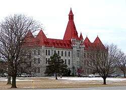
| Royal Military College of Canada Stone Frigate (No. 23) |
RMC Kingston, Kingston, ON |
44°14′00″N 76°28′00″W / 44.2333°N 76.4667°W / 44.2333; -76.4667 (Royal Military College of Canada Stone Frigate (No. 23)) |
4388 |
|
|
|

More images |
| Royal Military College of Canada, MacKenzie Building |
RMC Kingston, Kingston, ON |
44°14′00″N 76°28′00″W / 44.2333°N 76.4667°W / 44.2333; -76.4667 (Royal Military College of Canada, MacKenzie Building) |
4382 |
|
|
|
More images |
| Royal Military College, Old Gymnasium |
RMC Kingston, Kingston, ON |
44°14′00″N 76°28′00″W / 44.2333°N 76.4667°W / 44.2333; -76.4667 (Royal Military College, Old Gymnasium) |
4753 |
|
|
|
More images |
| Royal Military College, Yeo Hall Mess Building |
RMC Kingston, Kingston, ON |
44°14′00″N 76°28′00″W / 44.2333°N 76.4667°W / 44.2333; -76.4667 (Royal Military College, Yeo Hall Mess Building) |
4811 |
|
|
|
More images |
| St. Andrew's Manse |
146 Clergy Street East, Kingston, ON |
44°14′01″N 76°29′20″W / 44.2335°N 76.4888°W / 44.2335; -76.4888 (St. Andrew's Manse) |
|
|
10771 |
|
|
| St. Andrew's Presbyterian Church |
130 Clergy Street East, Kingston, ON |
44°13′57″N 76°29′20″W / 44.2326°N 76.489°W / 44.2326; -76.489 (St. Andrew's Presbyterian Church) |
|
|
10772 |
|
 |
| St. George's Cathedral |
270 King Street, Kingston, ON |
44°13′46″N 76°28′56″W / 44.2294°N 76.4823°W / 44.2294; -76.4823 (St. George's Cathedral) |
|
8197 |
|
|

More images |
| St. Helen's Complex, Stone Gables |
462 King Street West, Kingston, ON |
44°13′13″N 76°30′29″W / 44.2204°N 76.508°W / 44.2204; -76.508 (St. Helen's Complex, Stone Gables) |
4710 |
|
|
|
 |
| St. Helen's Complex: Red Cross Lodge |
440 King Street West, Kingston, ON |
44°13′13″N 76°30′29″W / 44.2204°N 76.508°W / 44.2204; -76.508 (St. Helen's Complex: Red Cross Lodge) |
6220 |
|
|
|
|
| St. Helen's Complex: St. Helen's |
440 King Street West, Kingston, ON |
44°13′13″N 76°30′29″W / 44.2204°N 76.508°W / 44.2204; -76.508 (St. Helen's Complex: St. Helen's) |
16462 |
|
|
|
|
| St. Helen's Complex: Grant House |
440 King Street West, Kingston, ON |
44°13′13″N 76°30′29″W / 44.2204°N 76.508°W / 44.2204; -76.508 (St. Helen's Complex: Grant House) |
4712 |
|
|
|
|
| Shelter |
Cedar Island, St. Lawrence Islands National Park, Kingston, ON |
44°13′42″N 76°27′02″W / 44.2282°N 76.4506°W / 44.2282; -76.4506 (Shelter) |
11280 |
|
|
|
|
| Shoal Tower National Historic Site of Canada |
Kingston Harbour, Kingston, ON |
44°13′44″N 76°28′41″W / 44.2289°N 76.4781°W / 44.2289; -76.4781 (Shoal Tower National Historic Site of Canada) |
11810 |
|
|
|
More images |
| Sir John A. Macdonald Gravesite National Historic Site of Canada |
Cataraqui Cemetery, Kingston, ON |
44°15′44″N 76°32′32″W / 44.2621°N 76.5421°W / 44.2621; -76.5421 (Sir John A. Macdonald Gravesite National Historic Site of Canada) |
12964 |
|
|
|
More images |
| South Workshop |
Kingston Penitentiary, Kingston, ON |
44°13′07″N 76°30′49″W / 44.2186°N 76.5136°W / 44.2186; -76.5136 (South Workshop) |
10243 |
|
|
|
|
| Vimy Barracks (B-6) |
CFB Kingston, Kingston, ON |
44°13′58″N 76°27′37″W / 44.2329°N 76.4603°W / 44.2329; -76.4603 (Vimy Barracks (B-6)) |
9800 |
|
|
|
|
| Vimy Barracks (C-1) |
CFB Kingston, Kingston, ON |
44°13′58″N 76°27′37″W / 44.2329°N 76.4603°W / 44.2329; -76.4603 (Vimy Barracks (C-1)) |
11303 |
|
|
|
|
| Vimy Barracks (Forde Building, B-16) |
CFB Kingston, Kingston, ON |
44°14′15″N 76°26′11″W / 44.2375°N 76.4363°W / 44.2375; -76.4363 (Vimy Barracks (Forde Building, B-16)) |
9801 |
|
|
|
|
| Vimy Barracks, Building B-1 |
CFB Kingston, Kingston, ON |
44°14′18″N 76°26′16″W / 44.2383°N 76.4378°W / 44.2383; -76.4378 (Vimy Barracks, Building B-1) |
9867 |
|
|
|
|
| Vincent Block / Administration Office |
Fort Frontenac, Kingston, ON |
44°14′02″N 76°28′41″W / 44.234°N 76.478°W / 44.234; -76.478 (Vincent Block / Administration Office) |
3311 |
|
|
|
|
| Wartman House |
86 Sunny Acres Road, Kingston, ON |
44°12′37″N 76°33′49″W / 44.2104°N 76.5635°W / 44.2104; -76.5635 (Wartman House) |
|
|
16303 |
|
More images |
| West Workshop |
Kingston Penitentiary, Kingston, ON |
44°13′08″N 76°30′50″W / 44.2189°N 76.514°W / 44.2189; -76.514 (West Workshop) |
10241 |
|
|
|
|