Ringstead Downs
| Site of Special Scientific Interest | |
 | |
| Area of Search | Norfolk |
|---|---|
| Grid reference | TF 691 400[1] |
| Interest | Biological |
| Area | 6.9 hectares (17 acres)[1] |
| Notification | 1986[1] |
| Location map | Magic Map |
Ringstead Downs is a 6.9-hectare (17-acre) biological Site of Special Scientific Interest east of Hunstanton in Norfolk.[1][2] It is in the Norfolk Coast Area of Outstanding Natural Beauty,[3] and it is the western part of the 11-hectare (27-acre) Ringstead Downs nature reserve, which is managed by the Norfolk Wildlife Trust.[4]
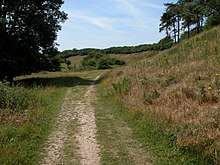
This is a dry chalk valley which was carved out by glacial meltwaters It is species-rich as it has never been ploughed, and it is the largest surviving area of chalk downland surviving in the county. The butterflies are diverse.[5]
A footpath between Ringstead and Downs Road in Hunstanton goes through the reserve.
References
- 1 2 3 4 "Designated Sites View: Ringstead Downs". Sites of Special Scientific Interest. Natural England. Retrieved 31 May 2018.
- ↑ "Map of Ringstead Downs". Sites of Special Scientific Interest. Natural England. Retrieved 31 May 2018.
- ↑ "Norfolk Coast AONB Management Plan 2014-19: Other Conservation Designations within the AONB" (PDF). Norfolk Coast AONB. Retrieved 25 May 2018.
- ↑ "Ringstead Downs". Norfolk Wildlife Trust. Retrieved 21 May 2018.
- ↑ "Ringstead Downs citation" (PDF). Sites of Special Scientific Interest. Natural England. Retrieved 31 May 2018.
| Wikimedia Commons has media related to Ringstead Downs. |
This article is issued from
Wikipedia.
The text is licensed under Creative Commons - Attribution - Sharealike.
Additional terms may apply for the media files.