Caistor St Edmund Chalk Pit
| Site of Special Scientific Interest | |
 | |
| Area of Search | Norfolk |
|---|---|
| Grid reference | TG 240 048[1] |
| Interest | Geological |
| Area | 23.6 hectares (58 acres)[1] |
| Notification | 1985[1] |
| Location map | Magic Map |
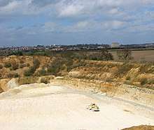
Caistor St Edmund Chalk Pit is a 23.6-hectare (58-acre) geological Site of Special Scientific Interest south of Norwich in Norfolk.[1][2] It is a Geological Conservation Review site.[3][4]
This site provides the best exposure of the late Campanian Beeston Chalk, around 75 million years ago. It is very fossiliferous, with many molluscs and sea urchins.[5]
The site is private land with no public access.
References
- 1 2 3 4 "Designated Sites View: Caistor St Edmund Chalk Pit". Sites of Special Scientific Interest. Natural England. Retrieved 7 June 2018.
- ↑ "Map of Caistor St Edmund Chalk Pit". Sites of Special Scientific Interest. Natural England. Retrieved 7 June 2018.
- ↑ "Caistor St Edmund Chalk Pit (Cenomanian, Turonian, Senonian, Maastrichtian)". Geological Conservation Review. Joint Nature Conservation Committee. Retrieved 25 May 2018.
- ↑ "Caistor St Edmund Pit (Quaternary of East Anglia)". Geological Conservation Review. Joint Nature Conservation Committee. Retrieved 25 May 2018.
- ↑ "Caistor St Edmund Chalk Pit citation" (PDF). Sites of Special Scientific Interest. Natural England. Retrieved 7 June 2018.
| Wikimedia Commons has media related to Caistor St Edmund Chalk Pit. |
This article is issued from
Wikipedia.
The text is licensed under Creative Commons - Attribution - Sharealike.
Additional terms may apply for the media files.