Description
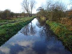
The meadows viewed from close to the riverside path
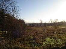
Enclosed between Norwich's outer ring road, industrial land and lying in the floodplain of the River Wensum the site acts as a 'green wedge' extending towards the city. The site consists of a series of unimproved wet meadows with permanent water-logging which support many plant species. Three principal grassland communities are present; damp neutral grassland, marshy grassland and areas of tall fen. A number of water-filled dykes bisect the site and attract large numbers of breeding amphibians in the spring months. Large flocks of redpoll and occasionally siskin feed on the alder trees that fringe the meadows. Many other bird species including snipe find the wet fields an ideal breeding habitat. The whole site is managed on traditional lines with light pony grazing without the use of artificial fertilizers and herbicides.
Location
Its western boundary is formed by the A140 outer ring road Sweet Briar Road. Marriott's Way NCR1 lies to the north and the Riverside Walk in the south. Mile Cross Marsh together with the adjacent Sycamore Crescent Wood are known collectively as the Wensum Local Nature Reserve[3] form the eastern boundary.
The site is private land with no public access but can be viewed from public footpaths.
References
Coordinates: 52°38′27″N 1°15′46″E / 52.6407°N 1.2628°E / 52.6407; 1.2628
|
|---|
| Biological |
- Alderfen Broad
- Alderford Common
- Ant Broads and Marshes
- Aslacton Parish Land
- Badley Moor
- Barnham Cross Common
- Beeston Cliffs
- Beetley and Hoe Meadows
- Blo' Norton and Thelnetham Fens
- Booton Common
- Boughton Fen
- Breckland Farmland
- Breckland Forest
- Breydon Water
- Bridgham and Brettenham Heaths
- The Brinks, Northwold
- Broad Fen, Dilham
- Bryant's Heath, Felmingham
- Bure Broads and Marshes
- Burgh Common and Muckfleet Marshes
- Buxton Heath
- Calthorpe Broad
- Cantley Marshes
- Castle Acre Common
- Cawston and Marsham Heaths
- Cockthorpe Common, Stiffkey
- Coston Fen, Runhall
- Cranberry Rough, Hockham
- Cranwich Camp
- Crostwick Marsh
- Damgate Marshes, Acle
- Decoy Carr, Acle
- Dereham Rush Meadow
- Dersingham Bog
- Didlington Park Lakes
- Dillington Carr
- Ducan's Marsh
- East Harling Common
- East Ruston Common
- East Walton and Adcock's Common
- East Winch Common
- East Wretham Heath
- Eaton Chalk Pit
- Edgefield Little Wood
- Elm Road Field, Thetford
- Felbrigg Woods
- Field Barn Heaths, Hilborough
- Flordon Common
- Forncett Meadows
- Foulden Common
- Foxley Wood
- Fritton Common, Morningthorpe
- Gawdyhall Big Wood, Harleston
- Geldeston Meadows
- Great Cressingham Fen
- Great Yarmouth North Denes
- Grime's Graves
- Gunton Park Lake
- Hall Farm Fen, Hemsby
- Halvergate Marshes
- Hardley Flood
- Hedenham Wood
- Hilgay Heronry
- Hockering Wood
- Holly Farm Meadow, Wendling
- Holt Lowes
- Honeypot Wood
- Hooks Well Meadows, Great Cressingham
- Horningtoft Wood
- Horse Wood, Mileham
- Hunstanton Cliffs
- Islington Heronry
- Kelling Heath
- Kenninghall and Banham Fens with Quidenham Mere
- Leziate, Sugar and Derby Fens
- Limpenhoe Meadows
- Lower Wood, Ashwellthorpe
- Ludham - Potter Heigham Marshes
- Mattishall Moor
- Middle Harling Fen
- Narborough Railway Embankment
- New Buckenham Common
- North Norfolk Coast
- Old Bodney Camp
- Old Buckenham Fen
- Ouse Washes
- Overstrand Cliffs
- Paston Great Barn
- Poplar Farm Meadows, Langley
- Potter and Scarning Fens, East Dereham
- Potter's Carr, Cranworth
- Priory Meadows, Hickling
- Pulham Market Big Wood
- Redgrave and Lopham Fens
- Ringstead Downs
- River Nar
- River Wensum
- Rosie Curston's Meadow, Mattishall
- Roydon Common
- Scoulton Mere
- Sea Mere, Hingham
- Sexton Wood
- Shallam Dyke Marshes, Thurne
- Shelfanger Meadows
- Sheringham and Beeston Regis Commons
- Shotesham Common
- Shotesham-Woodton Hornbeam Woods
- Sidestrand and Trimingham Cliffs
- Smallburgh Fen
- Snettisham Carstone Quarry
- Southrepps Common
- Stanford Training Area
- Stanley and Alder Carrs, Aldeby
- Stiffkey Valley
- Swangey Fen, Attleborough
- Swannington Upgate Common
- Swanton Novers Woods
- Sweetbriar Road Meadows, Norwich
- Syderstone Common
- Thetford Golf Course and Marsh
- Thompson Water, Carr and Common
- Tindall Wood, Ditchingham
- Trinity Broads
- Upper Thurne Broads and Marshes
- Upton Broad and Marshes
- Warham Camp
- The Wash
- Wayland Wood, Watton
- Weeting Heath
- Wells Chalk Pit
- Westwick Lakes
- Weybourne Cliffs
- Whitwell Common
- Winterton-Horsey Dunes
- Wiveton Downs
- Wretham Park Meres
- Yare Broads and Marshes
|
|---|
| Geological | |
|---|