Wiveton Downs
| Site of Special Scientific Interest | |
 | |
| Area of Search | Norfolk |
|---|---|
| Grid reference | TG 025 428[1] |
| Interest |
Biological Geological |
| Area | 28.9 hectares (71 acres)[1] |
| Notification | 1992[1] |
| Location map | Magic Map |
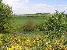
Wiveton Downs is a 28.9-hectare (71-acre) biological and geological Site of Special Scientific Interest west of Sheringham in Norfolk.[1][2] Part of it is a Geological Conservation Review site,[3][4] and an area of 6.5-hectare (16-acre) is a Local Nature Reserve[5][6] It is in the Norfolk Coast Area of Outstanding Natural Beauty.[7]
This is a classic example of an esker, a glacial crevasse which has been filled in until it forms a narrow winding ridge. It has been very important for teaching, research and demonstration.[8]
References
- 1 2 3 4 "Designated Sites View: Wiveton Downs". Sites of Special Scientific Interest. Natural England. Retrieved 23 June 2018.
- ↑ "Map of Wiveton Downs". Sites of Special Scientific Interest. Natural England. Retrieved 23 June 2018.
- ↑ "Wiveton Downs (Quaternary of East Anglia)". Geological Conservation Review. Joint Nature Conservation Committee. Retrieved 25 May 2018.
- ↑ "Blakeney Esker (Quaternary of East Anglia)". Geological Conservation Review. Joint Nature Conservation Committee. Retrieved 23 June 2018.
- ↑ "Designated Sites View: Wiveton Down". Local Nature Reserves. Natural England. Retrieved 21 May 2018.
- ↑ "Map of Wiveton Downs". Local Nature Reserves. Natural England. Retrieved 23 June 2018.
- ↑ "Norfolk Coast AONB Management Plan 2014-19: Other Conservation Designations within the AONB" (PDF). Norfolk Coast AONB. Retrieved 25 May 2018.
- ↑ "Wiveton Downs citation" (PDF). Sites of Special Scientific Interest. Natural England. Retrieved 23 June 2018.
| Wikimedia Commons has media related to Wiveton Downs. |
This article is issued from
Wikipedia.
The text is licensed under Creative Commons - Attribution - Sharealike.
Additional terms may apply for the media files.