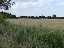
Shelfanger Meadows is a 10.3-hectare (25-acre) biological Site of Special Scientific Interest north of Diss in Norfolk.[1][2]
This site in the valley of a tributary of the River Waveney is described by Natural England as "one of the most important areas of unimproved grassland in Norfolk". It has been traditionally managed by a hay cut followed by grazing for hundreds of years, and as a result its flora is rich, including uncommon species. There are also areas where springs make the grassland marshy.[3]
The site is private land with no public access.
References
Coordinates: 52°24′11″N 1°05′56″E / 52.403°N 1.099°E / 52.403; 1.099
|
|---|
| Biological |
- Alderfen Broad
- Alderford Common
- Ant Broads and Marshes
- Aslacton Parish Land
- Badley Moor
- Barnham Cross Common
- Beeston Cliffs
- Beetley and Hoe Meadows
- Blo' Norton and Thelnetham Fens
- Booton Common
- Boughton Fen
- Breckland Farmland
- Breckland Forest
- Breydon Water
- Bridgham and Brettenham Heaths
- The Brinks, Northwold
- Broad Fen, Dilham
- Bryant's Heath, Felmingham
- Bure Broads and Marshes
- Burgh Common and Muckfleet Marshes
- Buxton Heath
- Calthorpe Broad
- Cantley Marshes
- Castle Acre Common
- Cawston and Marsham Heaths
- Cockthorpe Common, Stiffkey
- Coston Fen, Runhall
- Cranberry Rough, Hockham
- Cranwich Camp
- Crostwick Marsh
- Damgate Marshes, Acle
- Decoy Carr, Acle
- Dereham Rush Meadow
- Dersingham Bog
- Didlington Park Lakes
- Dillington Carr
- Ducan's Marsh
- East Harling Common
- East Ruston Common
- East Walton and Adcock's Common
- East Winch Common
- East Wretham Heath
- Eaton Chalk Pit
- Edgefield Little Wood
- Elm Road Field, Thetford
- Felbrigg Woods
- Field Barn Heaths, Hilborough
- Flordon Common
- Forncett Meadows
- Foulden Common
- Foxley Wood
- Fritton Common, Morningthorpe
- Gawdyhall Big Wood, Harleston
- Geldeston Meadows
- Great Cressingham Fen
- Great Yarmouth North Denes
- Grime's Graves
- Gunton Park Lake
- Hall Farm Fen, Hemsby
- Halvergate Marshes
- Hardley Flood
- Hedenham Wood
- Hilgay Heronry
- Hockering Wood
- Holly Farm Meadow, Wendling
- Holt Lowes
- Honeypot Wood
- Hooks Well Meadows, Great Cressingham
- Horningtoft Wood
- Horse Wood, Mileham
- Hunstanton Cliffs
- Islington Heronry
- Kelling Heath
- Kenninghall and Banham Fens with Quidenham Mere
- Leziate, Sugar and Derby Fens
- Limpenhoe Meadows
- Lower Wood, Ashwellthorpe
- Ludham - Potter Heigham Marshes
- Mattishall Moor
- Middle Harling Fen
- Narborough Railway Embankment
- New Buckenham Common
- North Norfolk Coast
- Old Bodney Camp
- Old Buckenham Fen
- Ouse Washes
- Overstrand Cliffs
- Paston Great Barn
- Poplar Farm Meadows, Langley
- Potter and Scarning Fens, East Dereham
- Potter's Carr, Cranworth
- Priory Meadows, Hickling
- Pulham Market Big Wood
- Redgrave and Lopham Fens
- Ringstead Downs
- River Nar
- River Wensum
- Rosie Curston's Meadow, Mattishall
- Roydon Common
- Scoulton Mere
- Sea Mere, Hingham
- Sexton Wood
- Shallam Dyke Marshes, Thurne
- Shelfanger Meadows
- Sheringham and Beeston Regis Commons
- Shotesham Common
- Shotesham-Woodton Hornbeam Woods
- Sidestrand and Trimingham Cliffs
- Smallburgh Fen
- Snettisham Carstone Quarry
- Southrepps Common
- Stanford Training Area
- Stanley and Alder Carrs, Aldeby
- Stiffkey Valley
- Swangey Fen, Attleborough
- Swannington Upgate Common
- Swanton Novers Woods
- Sweetbriar Road Meadows, Norwich
- Syderstone Common
- Thetford Golf Course and Marsh
- Thompson Water, Carr and Common
- Tindall Wood, Ditchingham
- Trinity Broads
- Upper Thurne Broads and Marshes
- Upton Broad and Marshes
- Warham Camp
- The Wash
- Wayland Wood, Watton
- Weeting Heath
- Wells Chalk Pit
- Westwick Lakes
- Weybourne Cliffs
- Whitwell Common
- Winterton-Horsey Dunes
- Wiveton Downs
- Wretham Park Meres
- Yare Broads and Marshes
|
|---|
| Geological | |
|---|