West Runton Cliffs
| Site of Special Scientific Interest | |
 | |
| Area of Search | Norfolk |
|---|---|
| Grid reference | TG 187 431[1] |
| Interest | Geological |
| Area | 17.8 hectares (44 acres)[1] |
| Notification | 1984[1] |
| Location map | Magic Map |
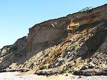
West Runton Cliffs is a 17.8-hectare (44-acre) geological Site of Special Scientific Interest east of Sheringham in Norfolk.[1][2] It is a Geological Conservation Review site.[3][4]
This site is important because it exposes a succession of warm and cold stages in the middle Pleistocene between about 2 million and 400,000 years ago. It shows a succession of advances and retreats of the sea, and it is the stratotype for the Cromerian Stage.[5]
The beach is open to the public.
References
- 1 2 3 4 "Designated Sites View: West Runton Cliffs". Sites of Special Scientific Interest. Natural England. Retrieved 22 June 2018.
- ↑ "Map of West Runton Cliffs". Sites of Special Scientific Interest. Natural England. Retrieved 22 June 2018.
- ↑ "West Runton (Pleistocene Vertebrata)". Geological Conservation Review. Joint Nature Conservation Committee. Retrieved 25 May 2018.
- ↑ "West Runton (Quaternary of East Anglia)". Geological Conservation Review. Joint Nature Conservation Committee. Retrieved 25 May 2018.
- ↑ "West Runton Cliffs citation" (PDF). Sites of Special Scientific Interest. Natural England. Retrieved 22 June 2018.
| Wikimedia Commons has media related to West Runton Cliffs. |
This article is issued from
Wikipedia.
The text is licensed under Creative Commons - Attribution - Sharealike.
Additional terms may apply for the media files.